1940s Maps of Greene County, Arkansas
Explore 5 historic maps of Greene County from the 1940s. These maps offer a rare glimpse into what life looked like during the 1940s — showing old roads, neighborhoods, homes, and landmarks that have changed or disappeared over time.
Whether you're researching your family's past, planning a metal detecting trip, or studying how Greene County's landscape evolved across the 1940s, these high-resolution maps are a powerful tool for exploring the history of this region.
- Focus on a specific era: All maps on this page are from the 1940s, giving you a focused view of this time period.
- See what’s changed: Compare century-old streets, trails, and buildings to today's modern landscape using overlays and satellite layers.
- Research with precision: Use these maps for genealogy, historical research, land use analysis, or educational projects.
- View, download, or print: Maps are fully viewable online in high resolution, and can be downloaded or printed for your own records.
Start exploring Greene County's history through authentic maps from the 1940s. This is your window into the past.
Greene County, AR maps
(5)- 1940 Map of Gainesville, 1942 Print
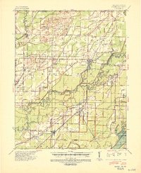
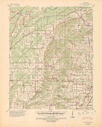 1940 Gainesville1942 Print · USGSGreene County was defined by its ridge and river bottomlands in the early 1940s, as rural communities thrived along the local railroads. Genealogists can trace family names through dozens of landmarks like Jones Ridge Cem, St Johns Ch & Cem, and Greene Co High Sch.2 unique versions available
 - 1940 Map of Marmaduke, 1942 Print
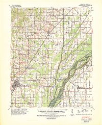 1940 Marmaduke1942 Print · USGSThe lowland border between Arkansas and Missouri comes into focus in the early 1940s, showing a landscape of river islands and new drainage ditches. Researchers can locate vanished rural landmarks like Bonecamp Sch, the Reddick Cem, and the tracks of the St Louis Southwestern Railway.3 unique versions available
 - 1940 Map of Kennett, 1943 Print
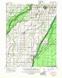 1940 Kennett1943 Print · USGSDunklin County and the Missouri-Arkansas border are mapped here during the early 1940s, showing a landscape defined by drainage ditches and rail lines. You can trace the St Louis Southwestern RR through Senath and Arbyrd, or locate family sites like Lula Ch & Cem and Johnson Mill.
 - 1941 Map of Leachville, 1943 Print
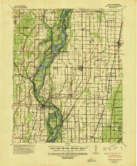 1941 Leachville1943 Print · USGSNortheast Arkansas and the Missouri bootheel border region appear here in the early 1940s as a landscape of river-bottom settlements and new drainage canals. Genealogists can trace family roots through numerous local schools like Turkey Run Sch and churches such as Walnut Grove Ch & Cem.
 - 1941 Map of Knobel, 1946 Print
 1941 Knobel1946 Print · USGSClay County at the onset of the 1940s is defined by the winding Black River and the critical rail junctions that sustained its small towns. Researchers can trace family roots through numerous rural landmarks like Masterson Cem, Brazil Sch & Ch, and the river crossing at Bennetts Ferry Bridge.2 unique versions available
End of results
Showing maps 1-5 of 5
Top cities of Greene County
- Paragould historical maps
- Marmaduke historical maps
- Oak Grove Heights historical maps
- Lafe historical maps
- Delaplaine historical maps
Frequently asked questions
- What are the different types of historical maps available for Greene County?
- What is the oldest map of Greene County?
- Where can I purchase historical maps of Greene County for my home or office?
- Where can I download high-res historical maps of Greene County?
- Are there historical topographic maps available for Greene County?
- Is there historical aerial imagery available for Greene County?
- Where are historical maps of Greene County sourced from?