1930s Maps of Greene County, Arkansas
Explore 8 historic maps of Greene County from the 1930s. These maps offer a rare glimpse into what life looked like during the 1930s — showing old roads, neighborhoods, homes, and landmarks that have changed or disappeared over time.
Whether you're researching your family's past, planning a metal detecting trip, or studying how Greene County's landscape evolved across the 1930s, these high-resolution maps are a powerful tool for exploring the history of this region.
- Focus on a specific era: All maps on this page are from the 1930s, giving you a focused view of this time period.
- See what’s changed: Compare century-old streets, trails, and buildings to today's modern landscape using overlays and satellite layers.
- Research with precision: Use these maps for genealogy, historical research, land use analysis, or educational projects.
- View, download, or print: Maps are fully viewable online in high resolution, and can be downloaded or printed for your own records.
Start exploring Greene County's history through authentic maps from the 1930s. This is your window into the past.
Greene County, AR maps
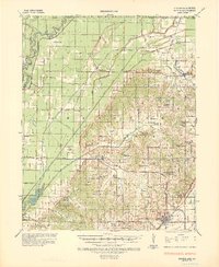
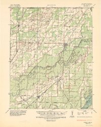
(8)- 1932 Map of Walnut Ridge
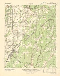 1932 Walnut Ridge1932 Print · USGSLawrence and Randolph counties come alive in the early thirties at the critical rail junction of Walnut Ridge. Genealogists and researchers can trace dozens of rural landmarks, from the Old Walnut Ridge Sch and Hoxie High Sch to local crossings like Indian Ford.
 - 1934 Map of Kennett
 1934 Kennett1934 Print · USGSDunklin County and the Arkansas borderlands are captured here during a period of intensive drainage and reclamation. Researchers can trace early infrastructure and family landmarks like Johnson Mill, American Legion Airport, and Bark Camp Sch.
 - 1935 Map of Sedgwick, 1936 Print
 1935 Sedgwick1936 Print · USGSLawrence and Craighead counties are shown here during a period of extensive drainage and rural expansion in the mid-1930s. Genealogists can trace family roots through numerous small landmarks like Three Way Inn, Fifty Six Sch, and Herman Ch & Cem.2 unique versions available
 - 1935 Map of Rector, 1936 Print
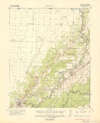
 1935 Rector1936 Print · USGSClay County at the height of the 1930s drainage era shows a landscape being reshaped by massive flood control projects and rail expansion. Genealogists can locate family landmarks like Boydsville, the Trovillon Cem, and rural schoolhouses such as Turtle Knob Sch.3 unique versions available
 - 1935 Map of Knobel, 1938 Print
 1935 Knobel1938 Print · USGSDuring the mid-1930s, the Arkansas-Missouri borderlands were defined by the rail lines and river bends of the Black River valley. Researchers can trace family roots through Peach Orchard, Hopewell Ch, and cemeteries like Al McNaner Cem.
 - 1935 Map of Reyno, 1938 Print
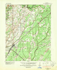
 1935 Reyno1938 Print · USGSRandolph and Clay counties are shown in the mid-1930s, documenting a river-dependent economy as the Ozarks meet the alluvial valley. Researchers can trace historic river crossings like Biggers Ferry and rural sites such as Johnson Cem and Cochrum Sch.3 unique versions available
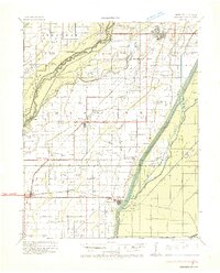
 - 1935 Map of Walnut Ridge, 1947 Print
 1935 Walnut Ridge1947 Print · USGSWalnut Ridge and Hoxie serve as a vital railroad crossroads during the mid-thirties, where the St. Louis-San Francisco and Missouri Pacific lines meet. Researchers can trace rural family roots through landmarks like Gum Stump Ch & Sch, Whitaker Cem, and the old settlement at Lesterville.2 unique versions available
 - 1939 Map of Jonesboro, 1942 Print
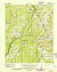
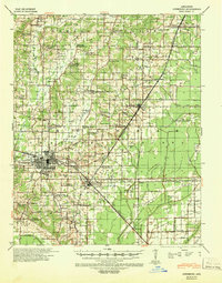 1939 Jonesboro1942 Print · USGSJonesboro and its surrounding farmstead communities are captured in the late thirties, when railroads and rural schools defined the region. Researchers can trace family sites like Higginsbottom Hope Sch or the remote Doss Flag Stop along the rail lines.
End of results
Showing maps 1-8 of 8
Top cities of Greene County
- Paragould historical maps
- Marmaduke historical maps
- Oak Grove Heights historical maps
- Lafe historical maps
- Delaplaine historical maps
Frequently asked questions
- What are the different types of historical maps available for Greene County?
- What is the oldest map of Greene County?
- Where can I purchase historical maps of Greene County for my home or office?
- Where can I download high-res historical maps of Greene County?
- Are there historical topographic maps available for Greene County?
- Is there historical aerial imagery available for Greene County?
- Where are historical maps of Greene County sourced from?