1980s Maps of Howard County, Arkansas
Explore 9 historic maps of Howard County from the 1980s. These maps offer a rare glimpse into what life looked like during the 1980s — showing old roads, neighborhoods, homes, and landmarks that have changed or disappeared over time.
Whether you're researching your family's past, planning a metal detecting trip, or studying how Howard County's landscape evolved across the 1980s, these high-resolution maps are a powerful tool for exploring the history of this region.
- Focus on a specific era: All maps on this page are from the 1980s, giving you a focused view of this time period.
- See what’s changed: Compare century-old streets, trails, and buildings to today's modern landscape using overlays and satellite layers.
- Research with precision: Use these maps for genealogy, historical research, land use analysis, or educational projects.
- View, download, or print: Maps are fully viewable online in high resolution, and can be downloaded or printed for your own records.
Start exploring Howard County's history through authentic maps from the 1980s. This is your window into the past.
Howard County, AR maps
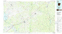
(9)- 1980 Map of Athens, 1981 Print
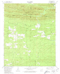 1980 Athens1981 Print · USGSThe rural Ouachita Mountains come into focus in the early 1980s, documenting the small community of Athens and its neighboring hills. Genealogists can trace family names at White Oak Cem or locate the old Mizels Chapel and Slate Pit.2 unique versions available
 - 1985 Map of Wickes
 1985 Wickes1985 Print · USGSThe Ouachita foothills of western Arkansas are seen here in the mid-1980s, centered on the railroad town of Wickes. Researchers can locate several family landmarks and rural institutions, including Daniel Cem, the Kansas City Southern line, and Crystal Hill Ch.
 - 1986 Map of Baker Springs
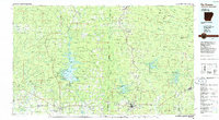
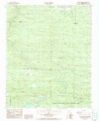 1986 Baker Springs1986 Print · USGSWestern Arkansas in the mid-eighties was a landscape of protected forests and river-fed basins near the Howard and Polk county line. Local historians can trace rural settlements like Baker Springs and Duckett or find extractive sites like the Shale Pit near the Cossatot River.
 - 1986 Map of Arkadelphia
 1986 Arkadelphia1986 Print · USGSSouthwest Arkansas in the mid-eighties shows a landscape of timbered ridges and significant new reservoirs. Researchers can trace rural schoolhouses and churches like Sunshine Sch and Hempwallace Ch alongside the famous Crater of Diamonds State Park.2 unique versions available
 - 1986 Map of Hope
 1986 Hope1986 Print · USGSSouthwest Arkansas in the mid-eighties was a landscape of rail-connected towns and timbered ridges. Researchers can trace the Missouri Pacific Railroad corridor through Hope or locate local landmarks like De Ann Cem and Poison Springs State Forest.2 unique versions available
 - 1986 Map of Umpire
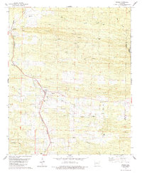
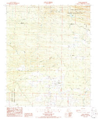 1986 Umpire1986 Print · USGSHoward County and the southern fringes of the national forest are captured here in the mid-eighties, showing a landscape of timber management and rural crossroads. Researchers can trace family sites around Umpire and Mineola or locate landmarks like the Shady Lake Recreation Area and Galena.2 unique versions available
 - 1986 Map of Idabel
 1986 Idabel1986 Print · USGSThe tri-state borderlands of Oklahoma, Arkansas, and Texas come alive in the 1980s, centered on the Red River and the timberlands of the Ouachita National Forest. Genealogists and historians can trace the paths of the Missouri Pacific railroad through towns like Bokhoma and Ashdown.
 - 1986 Map of De Queen
 1986 De Queen1986 Print · USGSThe Arkansas-Oklahoma borderlands are shown here in the mid-1980s, highlighting the complex water systems and mountain ridges of the Ouachita region. Genealogists and historians can trace rail routes like the Kansas City Southern and find old community sites such as Ultima Thule or Oak Grove Ch.2 unique versions available
 - 1989 Map of El Dorado, 1990 Print
 1989 El Dorado1990 Print · USGSThe Arkansas-Louisiana borderlands in the late eighties show a landscape of heavy industry and wildlife conservation centered on the Ouachita River. Researchers can trace the legacy of timber and transport via the Missouri Pacific RR, Poison Springs State Forest, and the vast Felsenthal Pool.
End of results
Showing maps 1-9 of 9
Top cities of Howard County
- Nashville historical maps
- Mineral Springs historical maps
- Dierks historical maps
- Tollette historical maps
Frequently asked questions
- What are the different types of historical maps available for Howard County?
- What is the oldest map of Howard County?
- Where can I purchase historical maps of Howard County for my home or office?
- Where can I download high-res historical maps of Howard County?
- Are there historical topographic maps available for Howard County?
- Is there historical aerial imagery available for Howard County?
- Where are historical maps of Howard County sourced from?