1960s Maps of Miller County, Arkansas
Explore 3 historic maps of Miller County from the 1960s. These maps offer a rare glimpse into what life looked like during the 1960s — showing old roads, neighborhoods, homes, and landmarks that have changed or disappeared over time.
Whether you're researching your family's past, planning a metal detecting trip, or studying how Miller County's landscape evolved across the 1960s, these high-resolution maps are a powerful tool for exploring the history of this region.
- Focus on a specific era: All maps on this page are from the 1960s, giving you a focused view of this time period.
- See what’s changed: Compare century-old streets, trails, and buildings to today's modern landscape using overlays and satellite layers.
- Research with precision: Use these maps for genealogy, historical research, land use analysis, or educational projects.
- View, download, or print: Maps are fully viewable online in high resolution, and can be downloaded or printed for your own records.
Start exploring Miller County's history through authentic maps from the 1960s. This is your window into the past.
Miller County, AR maps
(3)- 1960 Map of El Dorado
 1960 El Dorado1960 Print · USGSSouth Central Arkansas in the late fifties was a hub of energy production and defense industry. Researchers can trace the extensive Oil and Gas Fields around El Dorado or locate family landmarks like Old Park Cem and New Hope Church.
 - 1969 Map of Bloomburg, 1972 Print
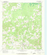 1969 Bloomburg1972 Print · USGSThe Texas-Arkansas borderlands in the late sixties are captured here as a landscape of timbered creek bottoms and small railroad towns. Genealogists can locate specific rural landmarks like Macedonia Cem, Golden Gate Ch, and the community of Bloomburg.
 - 1969 Map of Ravanna, 1973 Print
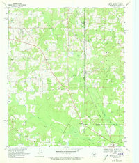 1969 Ravanna1973 Print · USGSThe tri-state border where Texas, Arkansas, and Louisiana meet comes alive in the late sixties, centered on the Rodessa Oil and Gas Field. Genealogists can trace family names through Beach Creek Cem and communities like Three States or Loutexark.2 unique versions available
End of results
Showing maps 1-3 of 3
Top cities of Miller County
Frequently asked questions
- What are the different types of historical maps available for Miller County?
- What is the oldest map of Miller County?
- Where can I purchase historical maps of Miller County for my home or office?
- Where can I download high-res historical maps of Miller County?
- Are there historical topographic maps available for Miller County?
- Is there historical aerial imagery available for Miller County?
- Where are historical maps of Miller County sourced from?