1930s Maps of Helena-West Helena, Arkansas
Explore 2 historic maps of Helena-West Helena from the 1930s. These maps offer a rare glimpse into what life looked like during the 1930s — showing old roads, neighborhoods, homes, and landmarks that have changed or disappeared over time.
Whether you're researching your family's past, planning a metal detecting trip, or studying how Helena-West Helena's landscape evolved across the 1930s, these high-resolution maps are a powerful tool for exploring the history of this region.
- Focus on a specific era: All maps on this page are from the 1930s, giving you a focused view of this time period.
- See what’s changed: Compare century-old streets, trails, and buildings to today's modern landscape using overlays and satellite layers.
- Research with precision: Use these maps for genealogy, historical research, land use analysis, or educational projects.
- View, download, or print: Maps are fully viewable online in high resolution, and can be downloaded or printed for your own records.
Start exploring Helena-West Helena's history through authentic maps from the 1930s. This is your window into the past.
Helena-West Helena, AR maps
(2)- 1939 Map of Farrell, 1941 Print
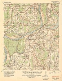 1939 Farrell1941 Print · USGSThe Mississippi Delta riverfront at Friar Point is captured here in the years before the Second World War. Researchers can trace family sites like Preston Places and Stovall or locate old rural centers including McLemore Sch and Llewellyn Ch & Sch.2 unique versions available
 - 1939 Map of Latour, 1944 Print
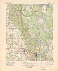 1939 Latour1944 Print · USGSPhillips County and the Mississippi Delta are shown here just before the Second World War as a landscape defined by river navigation and rail transport. Researchers can trace the footprints of communities like Helena and find family-named landmarks such as Tate Ldg, Zion Ch, and Flower Chapel Cemetery.2 unique versions available
End of results
Showing maps 1-2 of 2
Top cities near Helena-West Helena
- Marianna historical maps
- Jonestown historical maps
- Friars Point historical maps
- Elaine historical maps
- Lake View historical maps
- Coahoma historical maps
See more
Top neighborhoods of Helena-West Helena
- West Helena historical maps
- Helena Crossing historical maps
- Midland Heights historical maps
- Oak Forest historical maps
- Helena historical maps
- Holiday Hills historical maps
Frequently asked questions
- What are the different types of historical maps available for Helena-West Helena?
- What is the oldest map of Helena-West Helena?
- Where can I purchase historical maps of Helena-West Helena for my home or office?
- Where can I download high-res historical maps of Helena-West Helena?
- Are there historical topographic maps available for Helena-West Helena?
- Is there historical aerial imagery available for Helena-West Helena?
- Where are historical maps of Helena-West Helena sourced from?