1960s Maps of Helena-West Helena, Arkansas
Explore 5 historic maps of Helena-West Helena from the 1960s. These maps offer a rare glimpse into what life looked like during the 1960s — showing old roads, neighborhoods, homes, and landmarks that have changed or disappeared over time.
Whether you're researching your family's past, planning a metal detecting trip, or studying how Helena-West Helena's landscape evolved across the 1960s, these high-resolution maps are a powerful tool for exploring the history of this region.
- Focus on a specific era: All maps on this page are from the 1960s, giving you a focused view of this time period.
- See what’s changed: Compare century-old streets, trails, and buildings to today's modern landscape using overlays and satellite layers.
- Research with precision: Use these maps for genealogy, historical research, land use analysis, or educational projects.
- View, download, or print: Maps are fully viewable online in high resolution, and can be downloaded or printed for your own records.
Start exploring Helena-West Helena's history through authentic maps from the 1960s. This is your window into the past.
Helena-West Helena, AR maps
(5)- 1960 Map of Helena
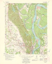
 1960 Helena1960 Print · USGSThe Arkansas and Mississippi Delta regions meet along the great river bends during a period of significant agricultural and rail expansion. Genealogists and historians can trace the paths of the Missouri Pacific railroad through Clarendon or locate landings along the Mississippi River and White River.
 - 1961 Map of Latour, 1965 Print
 1961 Latour1965 Print · USGSThe riverfront cities of Helena and West Helena are captured here in the early sixties, showing the vital rail-and-river hub at the edge of the St Francis National Forest. Family historians can locate dozens of rural landmarks, from Lexa and Southland to Mt Olive Ch and Trinity Cem.2 unique versions available
 - 1963 Map of Latour
 1963 Latour1963 Print · USGSPhillips County and the Mississippi River Delta appear here in the early sixties as a thriving network of river-bound commerce and rural communities. Genealogists can locate family landmarks such as Riedy Grove Cem, St Pauls Ch, and the historic industrial center at Helena Crossing.
 - 1964 Map of Moon Lake, 1965 Print
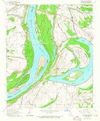 1964 Moon Lake1965 Print · USGSThe Mississippi River delta landscape comes alive in this mid-sixties survey, showcasing the complex waterways and rural settlements of the border region. Genealogists can trace family footprints through numerous local landmarks like Bethlehem Sch, Fredonia Cem, and Silver Cloud Ch.2 unique versions available
 - 1967 Map of Farrell
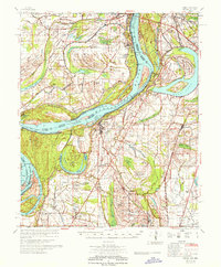 1967 Farrell1967 Print · USGSThe Mississippi Delta in the late sixties shows a landscape defined by industrial-scale agriculture and river engineering. Genealogists can trace family roots through numerous rural churches like Zion Traveler Ch and old estates such as Prairie Plantation or Stovall.
End of results
Showing maps 1-5 of 5
Top cities near Helena-West Helena
- Marianna historical maps
- Jonestown historical maps
- Friars Point historical maps
- Elaine historical maps
- Lake View historical maps
- Coahoma historical maps
See more
Top neighborhoods of Helena-West Helena
- West Helena historical maps
- Helena Crossing historical maps
- Midland Heights historical maps
- Oak Forest historical maps
- Helena historical maps
- Holiday Hills historical maps
Frequently asked questions
- What are the different types of historical maps available for Helena-West Helena?
- What is the oldest map of Helena-West Helena?
- Where can I purchase historical maps of Helena-West Helena for my home or office?
- Where can I download high-res historical maps of Helena-West Helena?
- Are there historical topographic maps available for Helena-West Helena?
- Is there historical aerial imagery available for Helena-West Helena?
- Where are historical maps of Helena-West Helena sourced from?