1960s Maps of Poinsett County, Arkansas
Explore 6 historic maps of Poinsett County from the 1960s. These maps offer a rare glimpse into what life looked like during the 1960s — showing old roads, neighborhoods, homes, and landmarks that have changed or disappeared over time.
Whether you're researching your family's past, planning a metal detecting trip, or studying how Poinsett County's landscape evolved across the 1960s, these high-resolution maps are a powerful tool for exploring the history of this region.
- Focus on a specific era: All maps on this page are from the 1960s, giving you a focused view of this time period.
- See what’s changed: Compare century-old streets, trails, and buildings to today's modern landscape using overlays and satellite layers.
- Research with precision: Use these maps for genealogy, historical research, land use analysis, or educational projects.
- View, download, or print: Maps are fully viewable online in high resolution, and can be downloaded or printed for your own records.
Start exploring Poinsett County's history through authentic maps from the 1960s. This is your window into the past.
Poinsett County, AR maps
(6)- 1960 Map of Weiner
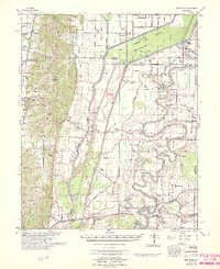
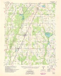 1960 Weiner1960 Print · USGSNortheast Arkansas at the dawn of the 1960s shows a landscape defined by the ST LOUIS SOUTHWESTERN rail line and reclaimed delta bottomlands. Researchers can trace rural life through landmarks like Walker Cem, Chilson Ch, and the sprawling Public Hunting Area.
 - 1962 Map of Princedale, 1968 Print
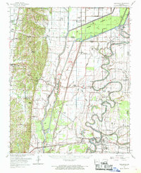 1962 Princedale1968 Print · USGSEastern Arkansas in the early sixties reveals a landscape shaped by Poinsett Ridge and the winding St. Francis River. Genealogists and local historians can trace family locations like Yarbo Place, rural landmarks such as McDonald Ch, and the stop at Cherry Valley Halt.
 - 1965 Map of Amagon, 1966 Print
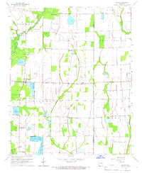 1965 Amagon1966 Print · USGSNortheast Arkansas in the mid-sixties is captured here as a landscape of managed wetlands and small rural communities. Genealogists can locate family burial sites at Carter Cem and Johnson Cem or trace the early industrial footprint of Stringers Mill.
 - 1965 Map of Grubbs, 1966 Print
 1965 Grubbs1966 Print · USGSNear the Cache River in the mid-1960s, this area of Jackson County shows a landscape of engineered drainage and small farming outposts. Researchers can locate several remote burial grounds and churches, including Denton Island Cem, Hollows Chapel, and the settlement of Grubbs.
 - 1966 Map of Princedale
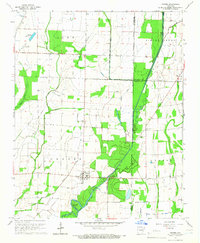
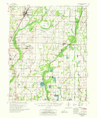
 1966 Princedale1966 Print · USGSEastern Arkansas river life in the mid-sixties centered on the complex drainage of the St Francis River. Genealogists can trace family landmarks like Burr Place and Harefarm Cem or rural centers like Wildwood Ch & Sch.
 - 1967 Map of Tuckerman
 1967 Tuckerman1967 Print · USGSThe Jackson County lowlands are captured here in the mid-sixties, showing a landscape defined by the Cache River and its sloughs. Trace family history at Gracelawn Cem, find old school sites like Eastside Sch, and locate industrial landmarks like Stringers Mill.
End of results
Showing maps 1-6 of 6
Top cities of Poinsett County
- Trumann historical maps
- Marked Tree historical maps
- Harrisburg historical maps
- Lepanto historical maps
- Tyronza historical maps
- Weiner historical maps
See more
Frequently asked questions
- What are the different types of historical maps available for Poinsett County?
- What is the oldest map of Poinsett County?
- Where can I purchase historical maps of Poinsett County for my home or office?
- Where can I download high-res historical maps of Poinsett County?
- Are there historical topographic maps available for Poinsett County?
- Is there historical aerial imagery available for Poinsett County?
- Where are historical maps of Poinsett County sourced from?