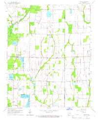
1965 Map of Amagon
USGS Topo · Published 1966About this map
The Cache River and its complex network of drainage ditches define the agricultural character of this Jackson and Poinsett County landscape in the mid-1960s. The settlement of Amagon serves as a central hub, surrounded by a grid of rural infrastructure that includes numerous Fish Hatchery ponds and the Stringers Mill site. This period shows a transition in land use, where natural waterways like Threemile Creek and Snake Slough are supplemented by man-made channels like the Cow Lake Ditch to manage the low-lying terrain of the Richwoods and Owen areas.
Find a feature on this map
27 named features on this map. Tap any name to fly to it.
Don’t see what you’re looking for? This feature index may not catch every label — zoom into the map to look around manually.
Map Details
Editions of this 1965 Amagon Map
This is the sole edition of this map. No revisions or reprints were ever made.
Other maps of this area

1935 · Tuckerman
USGS Topo · 1:62,500

1939 · Vanndale
USGS Topo · 1:62,500

1939 · Weiner
USGS Topo · 1:62,500

1940 · Tilton
USGS Topo · 1:62,500

1953 · Memphis
USGS Topo · 1:250,000

1956 · Memphis
USGS Topo · 1:250,000

1956 · Tilton
USGS Topo · 1:62,500

1958 · Vanndale
USGS Topo · 1:62,500

1959 · Weiner
USGS Topo · 1:62,500

1960 · Weiner
USGS Topo · 1:62,500