1990s Maps of Jacksonville, Arkansas
Explore 3 historic maps of Jacksonville from the 1990s. These maps offer a rare glimpse into what life looked like during the 1990s — showing old roads, neighborhoods, homes, and landmarks that have changed or disappeared over time.
Whether you're researching your family's past, planning a metal detecting trip, or studying how Jacksonville's landscape evolved across the 1990s, these high-resolution maps are a powerful tool for exploring the history of this region.
- Focus on a specific era: All maps on this page are from the 1990s, giving you a focused view of this time period.
- See what’s changed: Compare century-old streets, trails, and buildings to today's modern landscape using overlays and satellite layers.
- Research with precision: Use these maps for genealogy, historical research, land use analysis, or educational projects.
- View, download, or print: Maps are fully viewable online in high resolution, and can be downloaded or printed for your own records.
Start exploring Jacksonville's history through authentic maps from the 1990s. This is your window into the past.
Jacksonville, AR maps
(3)- 1994 Map of Cabot, 2000 Print
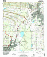 1994 Cabot2000 Print · USGSThe growing corridor between Cabot and Jacksonville is captured here during the mid-nineties, showing the mix of military, residential, and wild spaces. Genealogists and local historians can locate several family cemeteries like King Cem and Mt Carmel Cem, alongside landmarks like Crow Stadium.
 - 1994 Map of Mc Almont, 2000 Print
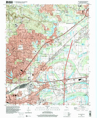 1994 Mc Almont2000 Print · USGSPulaski County in the mid-nineties shows the rapid suburbanization of the corridor between North Little Rock and Jacksonville. Genealogists can locate family sites like Meacham Cem and Hickman Memorial Cem near the rail junctions of McAlmont.
 - 1996 Map of Olmstead, 1999 Print
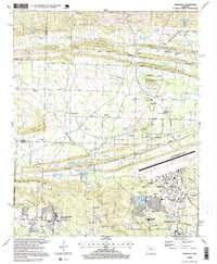 1996 Olmstead1999 Print · USGSPulaski County at the close of the twentieth century shows a distinct landscape where military infrastructure meets traditional rural settlements. Genealogists and local historians can locate country landmarks like Cato School, Harmony Church, and the sprawling Little Rock Air Force Base.
End of results
Showing maps 1-3 of 3
Top cities near Jacksonville
- Little Rock historical maps
- North Little Rock historical maps
- Cabot historical maps
- Sherwood historical maps
- Maumelle historical maps
- Beebe historical maps
See more
Top neighborhoods of Jacksonville
Frequently asked questions
- What are the different types of historical maps available for Jacksonville?
- What is the oldest map of Jacksonville?
- Where can I purchase historical maps of Jacksonville for my home or office?
- Where can I download high-res historical maps of Jacksonville?
- Are there historical topographic maps available for Jacksonville?
- Is there historical aerial imagery available for Jacksonville?
- Where are historical maps of Jacksonville sourced from?