1940s Maps of Jacksonville, Arkansas
Explore 3 historic maps of Jacksonville from the 1940s. These maps offer a rare glimpse into what life looked like during the 1940s — showing old roads, neighborhoods, homes, and landmarks that have changed or disappeared over time.
Whether you're researching your family's past, planning a metal detecting trip, or studying how Jacksonville's landscape evolved across the 1940s, these high-resolution maps are a powerful tool for exploring the history of this region.
- Focus on a specific era: All maps on this page are from the 1940s, giving you a focused view of this time period.
- See what’s changed: Compare century-old streets, trails, and buildings to today's modern landscape using overlays and satellite layers.
- Research with precision: Use these maps for genealogy, historical research, land use analysis, or educational projects.
- View, download, or print: Maps are fully viewable online in high resolution, and can be downloaded or printed for your own records.
Start exploring Jacksonville's history through authentic maps from the 1940s. This is your window into the past.
Jacksonville, AR maps
(3)- 1941 Map of Olmstead, 1945 Print
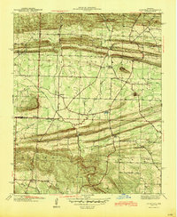 1941 Olmstead1945 Print · USGSNorth of Little Rock in the early 1940s, this area was a network of bayous and ridges punctuated by rural crossroads and family homesteads. Genealogists and local historians can trace legacy sites like Tates Mill, Sumner Cem, and several country meeting houses including Zion Hill Ch and Harmony Ch.
 - 1941 Map of Cabot, 1945 Print
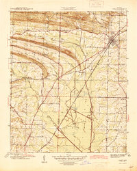 1941 Cabot1945 Print · USGSLonoke and Pulaski counties are captured in detail during the early 1940s, showing a landscape defined by prominent ridges and the Missouri Pacific rail line. Researchers can trace family sites near Concord Cem or locate historic rural centers like Holland and Mt Tabor Ch.2 unique versions available
 - 1943 Map of Jacksonville
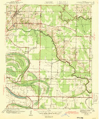 1943 Jacksonville1943 Print · USGSJacksonville and the Pulaski-Lonoke county line appear here in the early 1940s, revealing a landscape of rail junctions and rural homesteads. Genealogists can trace early family sites like Mc Graw Cem, the South Bend Sch, and the route of the Old Military Road.2 unique versions available
End of results
Showing maps 1-3 of 3
Top cities near Jacksonville
- Little Rock historical maps
- North Little Rock historical maps
- Cabot historical maps
- Sherwood historical maps
- Maumelle historical maps
- Beebe historical maps
See more
Top neighborhoods of Jacksonville
Frequently asked questions
- What are the different types of historical maps available for Jacksonville?
- What is the oldest map of Jacksonville?
- Where can I purchase historical maps of Jacksonville for my home or office?
- Where can I download high-res historical maps of Jacksonville?
- Are there historical topographic maps available for Jacksonville?
- Is there historical aerial imagery available for Jacksonville?
- Where are historical maps of Jacksonville sourced from?