1960s Maps of Little Rock, Arkansas
Explore 8 historic maps of Little Rock from the 1960s. These maps offer a rare glimpse into what life looked like during the 1960s — showing old roads, neighborhoods, homes, and landmarks that have changed or disappeared over time.
Whether you're researching your family's past, planning a metal detecting trip, or studying how Little Rock's landscape evolved across the 1960s, these high-resolution maps are a powerful tool for exploring the history of this region.
- Focus on a specific era: All maps on this page are from the 1960s, giving you a focused view of this time period.
- See what’s changed: Compare century-old streets, trails, and buildings to today's modern landscape using overlays and satellite layers.
- Research with precision: Use these maps for genealogy, historical research, land use analysis, or educational projects.
- View, download, or print: Maps are fully viewable online in high resolution, and can be downloaded or printed for your own records.
Start exploring Little Rock's history through authentic maps from the 1960s. This is your window into the past.
Little Rock, AR maps
(8)- 1960 Map of Little Rock
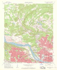
 1960 Little Rock1960 Print · USGSCentral Arkansas in the late fifties shows a landscape of growing military bases and massive new reservoirs. Local historians can trace the mid-century expansion of Little Rock and Hot Springs alongside the industrial works at Bauxite and the Pine Bluff Arsenal.
 - 1961 Map of North Little Rock, 1962 Print
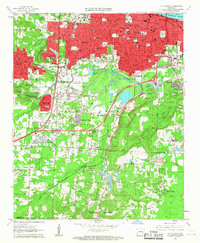
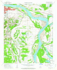
 1961 North Little Rock1962 Print · USGSThe riverfront and uplands of the Little Rock metro area are captured here in the early sixties, as suburban growth began to reach toward the hills. Genealogists and local historians can locate dozens of institutions, from St Josephs Orphanage and Shorter College to Palestine Cem.4 unique versions available
 - 1961 Map of Little Rock, 1962 Print
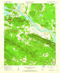
 1961 Little Rock1962 Print · USGSLittle Rock and its southern suburbs are captured in the early sixties during a transformative era of growth and industrial activity. Genealogists and researchers can locate historic institutions like Central High Sch, trace the Missouri Pacific rail lines, or find family plots in Oakland Cemetery and Calvary Cemetery.3 unique versions available
 - 1961 Map of Alexander, 1962 Print
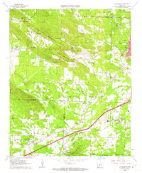 1961 Alexander1962 Print · USGSThe transition from rural Saline and Pulaski counties to suburban reach is evident here in the early 1960s. Genealogists can trace family names at Forest Hills Memorial Park, Mabelvale, and the Ida Mission Cem.4 unique versions available
 - 1961 Map of Pinnacle Mountain, 1962 Print
 1961 Pinnacle Mountain1962 Print · USGSThe peaks of the Arkansas River Valley stand tall in the early sixties, as suburban growth reaches toward the river's edge. Researchers can trace family history at the Old Soldiers Cem, visit the County Prison Farm, or locate the Pumping Station near Natural Steps.4 unique versions available
 - 1961 Map of Sweet Home, 1962 Print
 1961 Sweet Home1962 Print · USGSSoutheast of Little Rock in the early sixties, the river valley shows a mix of growing industrial hubs and small residential communities. Genealogists can locate family landmarks like Freeman Cemetery and rural churches such as Pilgrim Rest Church or St Stephens Church.4 unique versions available
 - 1963 Map of Ferndale, 1964 Print
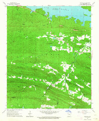 1963 Ferndale1964 Print · USGSPulaski County at the start of the 1960s reveals a landscape of ridge-top settlements and newly managed waterways. Researchers can locate numerous family burial sites and schools, such as Browns Valley of Rest Cem and the Joe T Robinson Sch.4 unique versions available
 - 1964 Map of Little Rock
 1964 Little Rock1964 Print · USGSCentral Arkansas in the mid-sixties is a landscape of mountain ridges, industrial rail lines, and growing military hubs. Researchers can trace the development of Bauxite and Hot Springs or locate rural landmarks like Sparkman and the Pine Bluff Arsenal.
End of results
Showing maps 1-8 of 8
Top cities near Little Rock
- North Little Rock historical maps
- Jacksonville historical maps
- Benton historical maps
- Sherwood historical maps
- Maumelle historical maps
- Bryant historical maps
See more
Top neighborhoods of Little Rock
- Spring Valley historical maps
- Pleasant Valley historical maps
- Pulaski Heights historical maps
- Rock Creek historical maps
- Brittain historical maps
- Pleasant Valley Estates historical maps
See more
Frequently asked questions
- What are the different types of historical maps available for Little Rock?
- What is the oldest map of Little Rock?
- Where can I purchase historical maps of Little Rock for my home or office?
- Where can I download high-res historical maps of Little Rock?
- Are there historical topographic maps available for Little Rock?
- Is there historical aerial imagery available for Little Rock?
- Where are historical maps of Little Rock sourced from?