1970s Maps of Randolph County, Arkansas
Explore 2 historic maps of Randolph County from the 1970s. These maps offer a rare glimpse into what life looked like during the 1970s — showing old roads, neighborhoods, homes, and landmarks that have changed or disappeared over time.
Whether you're researching your family's past, planning a metal detecting trip, or studying how Randolph County's landscape evolved across the 1970s, these high-resolution maps are a powerful tool for exploring the history of this region.
- Focus on a specific era: All maps on this page are from the 1970s, giving you a focused view of this time period.
- See what’s changed: Compare century-old streets, trails, and buildings to today's modern landscape using overlays and satellite layers.
- Research with precision: Use these maps for genealogy, historical research, land use analysis, or educational projects.
- View, download, or print: Maps are fully viewable online in high resolution, and can be downloaded or printed for your own records.
Start exploring Randolph County's history through authentic maps from the 1970s. This is your window into the past.
Randolph County, AR maps
(2)- 1974 Map of Noland, 1976 Print
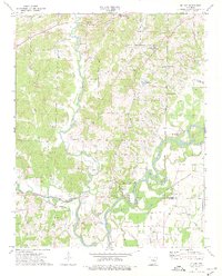 1974 Noland1976 Print · USGSThe river bottomlands of Randolph County were still largely defined by their winding waterways and small rural settlements in the mid-1970s. Researchers can trace family history through numerous remote cemeteries like Huffstedler Cem or locate the historic site of Old Davidsonville State Park.
 - 1974 Map of Black Rock, 1976 Print
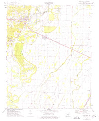 1974 Black Rock1976 Print · USGSLawrence County settlements and river confluences are captured here in the mid-seventies, showing the region's transition into the late twentieth century. You can trace family roots at Oak Forest Cem, locate the old Box Factory in Black Rock, or follow the rail lines through Portia.
End of results
Showing maps 1-2 of 2
Top cities of Randolph County
- Pocahontas historical maps
- Reyno historical maps
- Maynard historical maps
- Biggers historical maps
- O'Kean historical maps
- Ravenden Springs historical maps
Frequently asked questions
- What are the different types of historical maps available for Randolph County?
- What is the oldest map of Randolph County?
- Where can I purchase historical maps of Randolph County for my home or office?
- Where can I download high-res historical maps of Randolph County?
- Are there historical topographic maps available for Randolph County?
- Is there historical aerial imagery available for Randolph County?
- Where are historical maps of Randolph County sourced from?