1900s (20th Century) Maps of Fairfield Bay, Arkansas
Explore 12 historic maps of Fairfield Bay from the 1900s (20th Century). These maps offer a rare glimpse into what life looked like during the 1900s — showing old roads, neighborhoods, homes, and landmarks that have changed or disappeared over time.
Whether you're researching your family's past, planning a metal detecting trip, or studying how Fairfield Bay's landscape evolved across the 1900s, these high-resolution maps are a powerful tool for exploring the history of this region.
- Focus on a specific era: All maps on this page are from the 1900s, giving you a focused view of this time period.
- See what’s changed: Compare century-old streets, trails, and buildings to today's modern landscape using overlays and satellite layers.
- Research with precision: Use these maps for genealogy, historical research, land use analysis, or educational projects.
- View, download, or print: Maps are fully viewable online in high resolution, and can be downloaded or printed for your own records.
Start exploring Fairfield Bay's history through authentic maps from the 1900s. This is your window into the past.
Fairfield Bay, AR maps
(12)- 1956 Map of Russellville
 1956 Russellville1956 Print · USGSThe Arkansas River valley and the surrounding Boston Mountains are captured here in the mid-fifties, showing a landscape of small timber towns and new reservoirs. Genealogists can trace family roots through upland settlements like Pelsor and Witts Springs or locate the campus of Arkansas Polytechnic College.2 unique versions available
 - 1964 Map of Russellville
 1964 Russellville1964 Print · USGSMid-century Central Arkansas is defined here by the river-valley towns and the surrounding mountain ranges before the full expansion of the interstate system. Genealogists and historians can trace rail-town development along the Missouri Pacific Railroad and locate landmarks like Arkansas Polytechnic College or Petit Jean State Park.
 - 1973 Map of Fairfield Bay
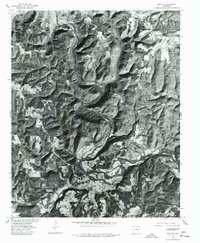
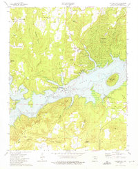 1973 Fairfield Bay1973 Print · USGSFairfield Bay and the surrounding Ozark foothills appear here in the early seventies, just as the area transitioned into a major recreation hub. Genealogists can locate family landmarks like Bradford Cem, Pine Grove Ch, and the rugged Alum Cave.3 unique versions available
 - 1973 Map of Greers Ferry, 1975 Print
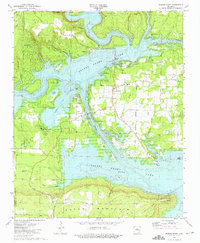 1973 Greers Ferry1975 Print · USGSThe Cleburne County shoreline in the early 1970s shows the growth of lakefront life alongside established mountain settlements. Genealogists and local historians can trace rural roots at Bailey Cemetery and West Side School, or locate the historic Treaty Trail.2 unique versions available
 - 1973 Map of Shirley, 1975 Print
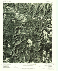
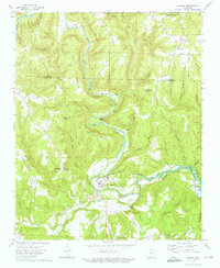 1973 Shirley1975 Print · USGSThe river town of Shirley and the budding community of Fairfield Bay are shown in the early seventies as this highland region transformed. Trace local family history at Settlement Cemetery or follow the path of the Old Railroad Grade along the river.3 unique versions available
 - 1973 Map of Parma, 1975 Print
 1973 Parma1975 Print · USGSThe northern reaches of the Ozarks meet the rising waters of Greers Ferry Lake in the early seventies. Genealogists and local historians can trace the settlements of Parma and Brewer, or locate the Smart Cem and Sunny Slope Ch.2 unique versions available
 - 1976 Map of Shirley, 1977 Print
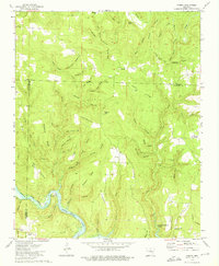
 1976 Shirley1977 Print · USGSIn the mid-1970s, the wooded hills of Van Buren County remained defined by the winding course of the Middle Fork Little Red River. Genealogists and local historians can trace the clearings and homesites around Shirley and Rushing as they appeared on the ground decades ago.
 - 1976 Map of Parma, 1977 Print
 1976 Parma1977 Print · USGSNorth-central Arkansas in the mid-seventies is captured in this detailed aerial perspective of the timbered ridges near Parma. Researchers can trace the winding course of the Middle Fork Little Red River and the expanding shoreline of Greers Ferry Lake.
 - 1977 Map of Russellville
 1977 Russellville1977 Print · USGSThe Arkansas River Valley and surrounding Ozark Mountains are documented here during a period of significant postwar growth and infrastructure development. Genealogists and researchers can locate family landmarks such as Mount Carmel Cem, St Josephs Church, and several remote Coal Mine sites along the Missouri Pacific RR line.
 - 1983 Map of Mountain View
 1983 Mountain View1983 Print · USGSNorth-central Arkansas comes into sharp focus during the early eighties, showing the transition from traditional Ozark mountain settlements to a landscape shaped by major reservoirs. Genealogists and historians can trace family roots through mountain hamlets like Snowball, Witts Springs, and Timbo, or locate landmarks such as Zion Hill Church and the Missouri Pacific Railroad.
 - 1984 Map of Russellville
 1984 Russellville1984 Print · USGSThe Arkansas River valley was undergoing significant change in the 1950s as transportation and water management reshaped the region from Russellville to Conway. Researchers can trace the era's rail networks like the Missouri Pacific RR and explore landmarks like Magazine Mountain and Petit Jean State Park.
 - 1992 Map of Russellville, 1993 Print
 1992 Russellville1993 Print · USGSCentral Arkansas in the early nineties shows a landscape defined by the Arkansas River valley and the surrounding national forests. Trace the development of river towns like Russellville and Dardanelle alongside landmarks such as Lake Dardanelle and Magazine Mtn.
End of results
Showing maps 1-12 of 12
Top cities near Fairfield Bay
- Heber Springs historical maps
- Mountain View historical maps
- Clinton historical maps
- Greers Ferry historical maps
- Quitman historical maps
- Shirley historical maps
See more
Frequently asked questions
- What are the different types of historical maps available for Fairfield Bay?
- What is the oldest map of Fairfield Bay?
- Where can I purchase historical maps of Fairfield Bay for my home or office?
- Where can I download high-res historical maps of Fairfield Bay?
- Are there historical topographic maps available for Fairfield Bay?
- Is there historical aerial imagery available for Fairfield Bay?
- Where are historical maps of Fairfield Bay sourced from?