1970s Maps of Fayetteville, Arkansas
Explore 7 historic maps of Fayetteville from the 1970s. These maps offer a rare glimpse into what life looked like during the 1970s — showing old roads, neighborhoods, homes, and landmarks that have changed or disappeared over time.
Whether you're researching your family's past, planning a metal detecting trip, or studying how Fayetteville's landscape evolved across the 1970s, these high-resolution maps are a powerful tool for exploring the history of this region.
- Focus on a specific era: All maps on this page are from the 1970s, giving you a focused view of this time period.
- See what’s changed: Compare century-old streets, trails, and buildings to today's modern landscape using overlays and satellite layers.
- Research with precision: Use these maps for genealogy, historical research, land use analysis, or educational projects.
- View, download, or print: Maps are fully viewable online in high resolution, and can be downloaded or printed for your own records.
Start exploring Fayetteville's history through authentic maps from the 1970s. This is your window into the past.
Fayetteville, AR maps
(7)- 1970 Map of Wheeler, 1972 Print
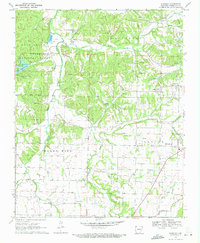 1970 Wheeler1972 Print · USGSNorthwest Arkansas was a mix of developing townships and forest preserves in the early seventies. You can trace the Old Railroad Grade through the hills or locate family sites near Bell Cem, Savoy, and the University of Arkansas Experimental Farm.4 unique versions available
 - 1970 Map of Springdale, 1972 Print
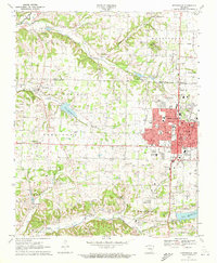 1970 Springdale1972 Print · USGSSpringdale and its neighbors in Washington and Benton counties are captured during a period of suburban expansion in the 1970s. Genealogists and local historians can locate specific landmarks like St Joseph Cem, New Hope Ch, and the old Salem Sch.3 unique versions available
 - 1973 Map of West Fork, 1976 Print
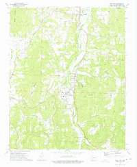 1973 West Fork1976 Print · USGSThe river valley south of Fayetteville comes into focus during the early 1970s, showing the Ozark landscape of West Fork and Greenland. Genealogists can trace family names and rural sites like Woolsey Cem, Friendship Ch, and Pitkin Corner.3 unique versions available
 - 1973 Map of Sulphur City, 1976 Print
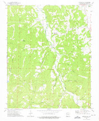 1973 Sulphur City1976 Print · USGSSulphur City and the rural hollows of Washington County are captured here in the early seventies, showing a landscape defined by the Middle Fork White River. Genealogists can trace family names at Salem Cem and Kings Cem or locate the site of Low Gap Ch.3 unique versions available
 - 1978 Map of Fort Smith, 1979 Print
 1978 Fort Smith1979 Print · USGSThe Arkansas-Oklahoma borderlands in the late seventies show a landscape shaped by massive river reservoirs and sprawling military reservations. Trace the historic rail lines of the Missouri Pacific RR and locate regional landmarks like Fort Gibson, Tenkiller Ferry Lake, and Barling.2 unique versions available
 - 1978 Map of Stilwell, 1979 Print
 1978 Stilwell1979 Print · USGSThe Oklahoma-Arkansas borderlands come alive in the late seventies, showing the transition from the Cherokee Nation hills to the Arkansas Ozarks. Researchers can trace the Kansas City Southern rail line through Stilwell, find Wrights Chapel, or locate the Northeastern State College campus in Tahlequah.
 - 1979 Map of Fayetteville, 1980 Print
 1979 Fayetteville1980 Print · USGSNorthwest Arkansas and the tristate corner show a booming corridor of rail-linked towns and highland forests in the late seventies. Researchers can trace historic landmarks like Pea Ridge National Military Park, the Frisco RR, and the University of Arkansas.2 unique versions available
End of results
Showing maps 1-7 of 7
Top cities near Fayetteville
- Springdale historical maps
- Rogers historical maps
- Bentonville historical maps
- Lowell historical maps
- Farmington historical maps
- Prairie Grove historical maps
See more
Top neighborhoods of Fayetteville
- Baldwin historical maps
- Fayette Junction historical maps
- White Rock historical maps
- Quarry Trace historical maps
- Candlewood historical maps
- Glenbrook Place historical maps
See more
Frequently asked questions
- What are the different types of historical maps available for Fayetteville?
- What is the oldest map of Fayetteville?
- Where can I purchase historical maps of Fayetteville for my home or office?
- Where can I download high-res historical maps of Fayetteville?
- Are there historical topographic maps available for Fayetteville?
- Is there historical aerial imagery available for Fayetteville?
- Where are historical maps of Fayetteville sourced from?