1900s (20th Century) Maps of White County, Arkansas
Explore 59 historic maps of White County from the 1900s (20th Century). These maps offer a rare glimpse into what life looked like during the 1900s — showing old roads, neighborhoods, homes, and landmarks that have changed or disappeared over time.
Whether you're researching your family's past, planning a metal detecting trip, or studying how White County's landscape evolved across the 1900s, these high-resolution maps are a powerful tool for exploring the history of this region.
- Focus on a specific era: All maps on this page are from the 1900s, giving you a focused view of this time period.
- See what’s changed: Compare century-old streets, trails, and buildings to today's modern landscape using overlays and satellite layers.
- Research with precision: Use these maps for genealogy, historical research, land use analysis, or educational projects.
- View, download, or print: Maps are fully viewable online in high resolution, and can be downloaded or printed for your own records.
Start exploring White County's history through authentic maps from the 1900s. This is your window into the past.
White County, AR maps
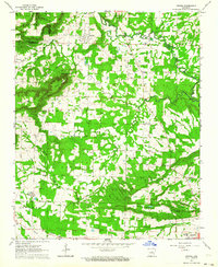
(59)- 1932 Map of Kensett
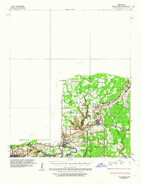
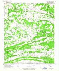
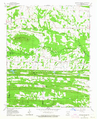
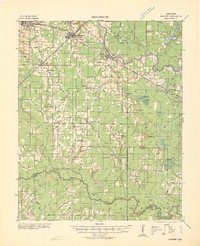 1932 Kensett1932 Print · USGSWhite County in the early thirties is a bustling corridor of rail activity and river commerce. Genealogists and local historians can trace family-named sites across the bottomlands, including Dogwood Ch & Cem, Holloway Sch, and the junction at Kensett.
 - 1935 Map of Kensett
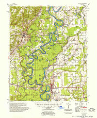
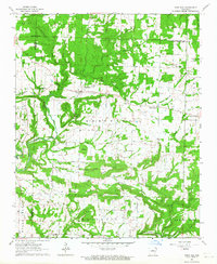
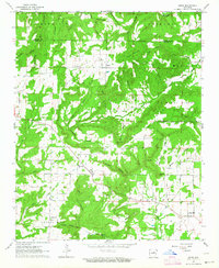
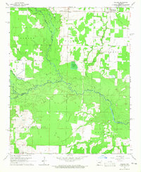
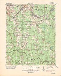 1935 Kensett1935 Print · USGSWhite County in the mid-1930s was defined by the winding Little Red River and a busy network of Missouri Pacific rail lines. Local historians can locate vanished community landmarks like Holloway Sch, Egbert Cem, and the village of Griffithville.2 unique versions available
 - 1935 Map of Augusta, 1938 Print
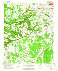
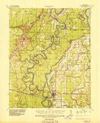 1935 Augusta1938 Print · USGSThe Arkansas Delta comes alive in the mid-1930s as the White River winds past the railroad hubs of Augusta and New Augusta. Genealogists can locate family landmarks like Spriggs Mill, Holly Grove Church, and various river landings including Hames Ferry.2 unique versions available
 - 1935 Map of Gregory, 1946 Print
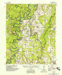
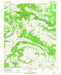
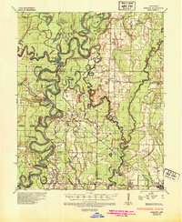 1935 Gregory1946 Print · USGSThe Arkansas Delta comes to life in the mid-1930s, showing a river-rich landscape of timber and rail commerce. Genealogists can trace family footprints through rural landmarks like Revel Cem, McClelland, and the riverfront at Georgetown.
 - 1935 Map of Bald Knob, 1963 Print
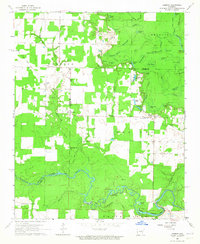
 1935 Bald Knob1963 Print · USGSWhite County during the mid-1930s is defined by its rail-linked towns and the winding Little Red River. Researchers can trace numerous vanished landmarks, from the Seven Day Sch and Big Four Sch to the Missouri Pacific Railroad corridor.
 - 1953 Map of Memphis, 1966 Print
 1953 Memphis1966 Print · USGSEastern Arkansas and the Memphis riverfront are shown here during the mid-century period of regional growth and river management. Local historians can trace the paths of the Chicago Rock Island & Pacific RR through Forrest City or locate river landmarks like President's Island.3 unique versions available
 - 1956 Map of Memphis
 1956 Memphis1956 Print · USGSThe Mississippi Delta and the bluffs of West Tennessee meet in the mid-fifties, showing a landscape defined by massive river systems and rail hubs. Researchers can trace the path of Crowleys Ridge or locate vanished river landings near Centennial Island and Island No 35.
 - 1956 Map of Russellville
 1956 Russellville1956 Print · USGSThe Arkansas River valley and the surrounding Boston Mountains are captured here in the mid-fifties, showing a landscape of small timber towns and new reservoirs. Genealogists can trace family roots through upland settlements like Pelsor and Witts Springs or locate the campus of Arkansas Polytechnic College.2 unique versions available
 - 1957 Map of Augusta
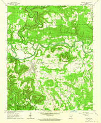
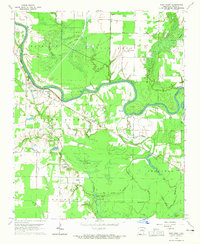
 1957 Augusta1957 Print · USGSThe White River Delta in the late fifties was a network of oxbow lakes and rail-dependent river towns. Researchers can trace family roots through numerous rural landmarks like Holly Grove Ch & Cem, Old Grand Glaise, and the Woodruff Co Sch.
 - 1957 Map of Gregory
 1957 Gregory1957 Print · USGSThe White River valley comes into sharp focus during the late fifties, showing a landscape of river-bend settlements and rail hubs. Genealogists can trace family names and rural communities through Walnut Grove Sch, Crutcher Cem, and the streets of Cotton Plant.
 - 1962 Map of Pangburn, 1964 Print
 1962 Pangburn1964 Print · USGSAcross the Little Red River valley in the early sixties, this area shows a landscape of upland ridges and river-bottom farms. Genealogists can locate family landmarks like Barnett Cem and Hickory Flat, or trace the Old Railroad Grade through Pangburn.3 unique versions available
 - 1962 Map of Letona, 1964 Print
 1962 Letona1964 Print · USGSIn the early sixties, this portion of White County remained a landscape of small settlements and traditional rural life. Genealogists can trace family footprints at New Hope Cem, the Morris Institute, or the remote community of Albion.3 unique versions available
 - 1963 Map of Rose Bud, 1964 Print
 1963 Rose Bud1964 Print · USGSThe rolling hills of White County are captured here in the early sixties, centered on the rural crossroads of Rose Bud. Genealogists can locate family landmarks like Moon Cem and Liberty Hill Cem or trace the early paths of ARK 25 and ARK 31.2 unique versions available
 - 1963 Map of Garner, 1964 Print
 1963 Garner1964 Print · USGSWhite County in the early sixties shows a landscape of prominent ridges and bottomlands along the Missouri Pacific Railroad. Genealogists and historians can locate the Garner Sch, the Weir Cem, and several rural churches including Honey Hill Ch.3 unique versions available
 - 1963 Map of Floyd, 1964 Print
 1963 Floyd1964 Print · USGSWhite County settlements and high ridges come into focus in the early sixties, showing a landscape defined by upland farming and river valleys. Genealogists can trace family footprints at Antioch Cem and Quattlebaum Cem, or locate landmarks like Red Bluff and Floyd.3 unique versions available
 - 1963 Map of Mount Vernon, 1964 Print
 1963 Mount Vernon1964 Print · USGSCentral Arkansas in the early sixties was a landscape of ridge-top settlements and creek-side farming communities across Faulkner and White counties. Genealogists can trace family roots through several small burial grounds and rural pulpits, including Oliver Cem, Royal Hill Ch, and Adkisson Cem.3 unique versions available
 - 1963 Map of Sidon, 1964 Print
 1963 Sidon1964 Print · USGSThe rural uplands of White County are captured in the early sixties as a network of ridge-top farms and creek-bottom communities. Genealogists and local historians can trace the foundations of Sidon and Center Hill, locating Sidon Cem and Mt Hebron Ch.2 unique versions available
 - 1963 Map of Beebe, 1964 Print
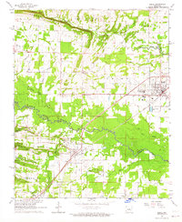 1963 Beebe1964 Print · USGSBeebe and the surrounding Lonoke and White County borderlands are captured here in the early sixties as the railroad era transitioned into the modern age. Genealogists can trace family landmarks like Stony Point Cem, Apple Hill Ch, and Union Valley Ch.3 unique versions available
 - 1963 Map of Mc Rae, 1964 Print
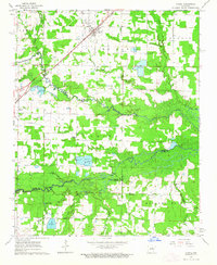 1963 Mc Rae1964 Print · USGSThe rail-and-creek landscape of White County comes into focus in the early sixties as the Missouri Pacific connects McRae and Beebe. Local researchers can trace family roots at Bass Cem or Green Cem and locate community landmarks like Harrison Chapel.3 unique versions available
 - 1963 Map of Mountain Springs, 1964 Print
 1963 Mountain Springs1964 Print · USGSCentral Arkansas in the early sixties was a landscape of remote ridges and tight-knit rural parishes. Genealogists can trace family names through the Shurley Cem or Barger Cem and locate historic meeting places like Baugh Chapel and Sixteenth Section Ch.3 unique versions available
 - 1964 Map of Russellville
 1964 Russellville1964 Print · USGSMid-century Central Arkansas is defined here by the river-valley towns and the surrounding mountain ranges before the full expansion of the interstate system. Genealogists and historians can trace rail-town development along the Missouri Pacific Railroad and locate landmarks like Arkansas Polytechnic College or Petit Jean State Park.
 - 1964 Map of Walker, 1965 Print
 1964 Walker1965 Print · USGSThe bottomlands of White and Prairie counties are captured here in the mid-1960s, showing a landscape defined by the winding Des Arc Bayou. Genealogists can locate family landmarks such as Walker Cem and Vinity Corner, or trace the path of the Old Railroad Grade near Griffithville.2 unique versions available
 - 1964 Map of Kensett, 1965 Print
 1964 Kensett1965 Print · USGSWhite County enters the mid-sixties with the bustling hub of SEARCY and its Harding College campus set against a rail-driven countryside. Local researchers can trace family landmarks and cemeteries like Lessenberry Cem and Liberty Cem or follow the Missouri Pacific line.3 unique versions available
 - 1964 Map of Jasmine, 1965 Print
 1964 Jasmine1965 Print · USGSPrairie and White counties in the mid-1960s reveal a landscape of river brakes and small rural settlements. Researchers can trace family roots through the Belcher Cem, Griffin Cem, and churches like Judson Memorial Ch or Friendship Ch.
 - 1964 Map of West Point, 1965 Print
 1964 West Point1965 Print · USGSWhite County, Arkansas, during the mid-sixties reveals a riverine landscape dominated by the Little Red River and its intricate wetlands. Genealogists and local historians can trace the foundations of West Point and find markers like New Hope Ch, Riverside Cem, and the Old Railroad Grade.2 unique versions available
Showing maps 1-25 of 59
Top cities of White County
- Searcy historical maps
- Beebe historical maps
- Bald Knob historical maps
- Judsonia historical maps
- Kensett historical maps
- Bradford historical maps
See more
Frequently asked questions
- What are the different types of historical maps available for White County?
- What is the oldest map of White County?
- Where can I purchase historical maps of White County for my home or office?
- Where can I download high-res historical maps of White County?
- Are there historical topographic maps available for White County?
- Is there historical aerial imagery available for White County?
- Where are historical maps of White County sourced from?