1970s Maps of White County, Arkansas
Explore 4 historic maps of White County from the 1970s. These maps offer a rare glimpse into what life looked like during the 1970s — showing old roads, neighborhoods, homes, and landmarks that have changed or disappeared over time.
Whether you're researching your family's past, planning a metal detecting trip, or studying how White County's landscape evolved across the 1970s, these high-resolution maps are a powerful tool for exploring the history of this region.
- Focus on a specific era: All maps on this page are from the 1970s, giving you a focused view of this time period.
- See what’s changed: Compare century-old streets, trails, and buildings to today's modern landscape using overlays and satellite layers.
- Research with precision: Use these maps for genealogy, historical research, land use analysis, or educational projects.
- View, download, or print: Maps are fully viewable online in high resolution, and can be downloaded or printed for your own records.
Start exploring White County's history through authentic maps from the 1970s. This is your window into the past.
White County, AR maps
(4)- 1971 Map of Augusta
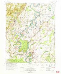 1971 Augusta1971 Print · USGSThe White River delta in the early 1970s is a maze of oxbow lakes and sloughs where rail and river networks meet. Genealogists and historians can trace rural family landmarks like Honey Grove Ch, McKnight Cem, and the old Spriggs Mill.
 - 1972 Map of Gregory
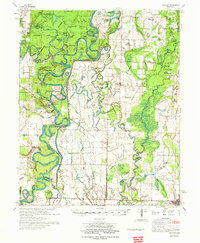 1972 Gregory1972 Print · USGSIn the Arkansas Delta during the early 1970s, the river-carved landscape of Woodruff and White counties supported a mix of timber and agriculture. Trace the footprints of rural life at Cotton Plant, Georgetown, and the Indian Mound Cemetery.2 unique versions available
 - 1973 Map of Floral, 1975 Print
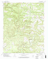 1973 Floral1975 Print · USGSThe rural uplands of Independence County are shown in the early seventies, centered on the community of Floral. Genealogists and local historians can trace family ties through several remote burial grounds and churches, including Warren Cem, Mason Cem, and Harris Chapel.2 unique versions available
 - 1977 Map of Russellville
 1977 Russellville1977 Print · USGSThe Arkansas River Valley and surrounding Ozark Mountains are documented here during a period of significant postwar growth and infrastructure development. Genealogists and researchers can locate family landmarks such as Mount Carmel Cem, St Josephs Church, and several remote Coal Mine sites along the Missouri Pacific RR line.
End of results
Showing maps 1-4 of 4
Top cities of White County
- Searcy historical maps
- Beebe historical maps
- Bald Knob historical maps
- Judsonia historical maps
- Kensett historical maps
- Bradford historical maps
See more
Frequently asked questions
- What are the different types of historical maps available for White County?
- What is the oldest map of White County?
- Where can I purchase historical maps of White County for my home or office?
- Where can I download high-res historical maps of White County?
- Are there historical topographic maps available for White County?
- Is there historical aerial imagery available for White County?
- Where are historical maps of White County sourced from?