1940s Maps of Livermore, California
Explore 5 historic maps of Livermore from the 1940s. These maps offer a rare glimpse into what life looked like during the 1940s — showing old roads, neighborhoods, homes, and landmarks that have changed or disappeared over time.
Whether you're researching your family's past, planning a metal detecting trip, or studying how Livermore's landscape evolved across the 1940s, these high-resolution maps are a powerful tool for exploring the history of this region.
- Focus on a specific era: All maps on this page are from the 1940s, giving you a focused view of this time period.
- See what’s changed: Compare century-old streets, trails, and buildings to today's modern landscape using overlays and satellite layers.
- Research with precision: Use these maps for genealogy, historical research, land use analysis, or educational projects.
- View, download, or print: Maps are fully viewable online in high resolution, and can be downloaded or printed for your own records.
Start exploring Livermore's history through authentic maps from the 1940s. This is your window into the past.
Livermore, CA maps
(5)- 1941 Map of Pleasanton
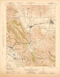
 1941 Pleasanton1941 Print · USGSThe Livermore Valley and East Bay hills are captured here in the early 1940s, showing a world of cattle ranchos and railroad towns. You can trace early landmarks like the Mission San Jose de Guadalupe, the Livermore Airport, and several rural one-room schoolhouses like Antone Sch.
 - 1942 Map of Altamont, 1964 Print
 1942 Altamont1964 Print · USGSEastern Alameda County at the start of the war shows a landscape of rail sidings and cattle ranching as the valley meets the ridges. Genealogists and historians can trace family locations like Mendenhall Ranch, rural landmarks like Green School, and the steep rail route through Altamont.
 - 1943 Map of Pleasanton
 1943 Pleasanton1943 Print · USGSThe Livermore and Amador Valleys are captured during the early 1940s, showing a landscape of ranching, railroads, and early institutional development. Genealogists and historians can locate old schools like Stonybrook Sch and landmarks such as Mission San Jose de Guadalupe.
 - 1943 Map of Tesla
 1943 Tesla1943 Print · USGSThe Livermore Valley and the rugged Diablo Range are shown during the early 1940s, featuring the critical rail junction at Altamont. Genealogists and historians can locate rural landmarks like the Green School, the Mendenhall Ranch, and the isolated Pointers Homestead.
 - 1947 Map of San Jose, 1948 Print
 1947 San Jose1948 Print · USGSNorthern California's heartland is captured here just after the war, showing the rapid growth of the Santa Clara and Central Valleys. Researchers can trace the legacy of rail and water at Castle Air Force Base, Stockton, and the Hetch Hetchy Aqueduct.
End of results
Showing maps 1-5 of 5
Top cities near Livermore
- San Jose historical maps
- Fremont historical maps
- Hayward historical maps
- Sunnyvale historical maps
- Tracy historical maps
- Milpitas historical maps
See more
Top neighborhoods of Livermore
- Ulmar historical maps
- Arrowhead Estates historical maps
- Altamar Meadows historical maps
- Amber Ridge historical maps
- Autumn Springs historical maps
- The Meadows historical maps
See more
Frequently asked questions
- What are the different types of historical maps available for Livermore?
- What is the oldest map of Livermore?
- Where can I purchase historical maps of Livermore for my home or office?
- Where can I download high-res historical maps of Livermore?
- Are there historical topographic maps available for Livermore?
- Is there historical aerial imagery available for Livermore?
- Where are historical maps of Livermore sourced from?