1950s Maps of Markleeville, California
Explore 2 historic maps of Markleeville from the 1950s. These maps offer a rare glimpse into what life looked like during the 1950s — showing old roads, neighborhoods, homes, and landmarks that have changed or disappeared over time.
Whether you're researching your family's past, planning a metal detecting trip, or studying how Markleeville's landscape evolved across the 1950s, these high-resolution maps are a powerful tool for exploring the history of this region.
- Focus on a specific era: All maps on this page are from the 1950s, giving you a focused view of this time period.
- See what’s changed: Compare century-old streets, trails, and buildings to today's modern landscape using overlays and satellite layers.
- Research with precision: Use these maps for genealogy, historical research, land use analysis, or educational projects.
- View, download, or print: Maps are fully viewable online in high resolution, and can be downloaded or printed for your own records.
Start exploring Markleeville's history through authentic maps from the 1950s. This is your window into the past.
Markleeville, CA maps
(2)- 1956 Map of Markleeville, 1959 Print
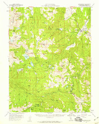 1956 Markleeville1959 Print · USGSThe Alpine County high country is mapped in the mid-1950s, showing a landscape of mining claims and mountain passes. Trace the history of the Silver Mountain district near Silver Mtn (Site) or locate landmarks like Grovers Hot Springs and Hangmans Bridge.4 unique versions available
 - 1957 Map of Walker Lake
 1957 Walker Lake1957 Print · USGSThe Nevada-California borderlands in the mid-1950s show a rugged network of mining camps and river-valley towns centered around Walker Lake. Researchers can trace the Southern Pacific rail line and locate historical sites like Bodie, Sodaville, and the Leviathan Sulphur Mine.4 unique versions available
End of results
Showing maps 1-2 of 2
Top cities near Markleeville
- South Lake Tahoe historical maps
- Meyers historical maps
- Ruhenstroth historical maps
- Carter Springs historical maps
- Alpine Village historical maps
- Mesa Vista historical maps
See more
Top neighborhoods of Markleeville
Frequently asked questions
- What are the different types of historical maps available for Markleeville?
- What is the oldest map of Markleeville?
- Where can I purchase historical maps of Markleeville for my home or office?
- Where can I download high-res historical maps of Markleeville?
- Are there historical topographic maps available for Markleeville?
- Is there historical aerial imagery available for Markleeville?
- Where are historical maps of Markleeville sourced from?