Old Maps of Alpine County, California for Metal Detecting
Plan your next treasure hunt with 176 historic maps of Alpine County. Find old homesites, ghost towns, trails, and gathering spots that may be lost to time — perfect for identifying promising metal detecting locations.
- Locate forgotten sites: Uncover places like long-lost settlements, abandoned rail lines, or gathering spots.
- Plan better hunts: Use map overlays combined with LiDAR or satellite views to narrow in on historically rich areas.
- Made for detectorists: Thousands of hobbyists use these maps to discover relics, coins, and hidden history.
Use these historic maps to boost your research and find new opportunities beneath the surface of Alpine County.
Alpine County, CA maps
(176)- 1889 Map of Pyramid Peak, 1954 Print
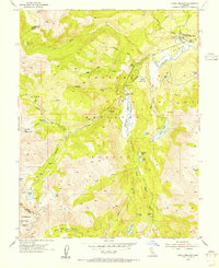
 1889 Pyramid Peak1954 Print · USGSThe high Sierra and Lake Tahoe shores appear here in the late nineteenth century, long before the arrival of modern highways. Researchers can locate early alpine outposts and family homesteads like Uncle Toms Cabin, Glen Alpine Springs, and Yanks.
 - 1889 Map of Markleeville, 1954 Print
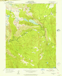
 1889 Markleeville1954 Print · USGSThe high Sierra and Carson Valley come alive in the late nineteenth century, showing a network of stage stops and mountain camps. Researchers can trace early settlements and family landmarks such as Markleeville, Walleys Hot Springs, and Tim Smiths.
 - 1891 Map of Markleeville
 1891 Markleeville1891 Print · USGSThe High Sierra and Carson Valley frontier come alive in the late nineteenth century, showing the rugged borderlands of California and Nevada. Researchers can trace early waystations and family outposts like Twelve Mile House, Hangman's Bridge, and Walleys Hot Springs.
 - 1891 Map of Big Trees
 1891 Big Trees1891 Print · USGSThe Sierra Nevada high country and gold country are seen here in the 1890s, a period defined by the mining economy and early mountain passage. Historians can trace early routes like the Bloods Toll Road and locate sites such as Sheep Ranch, the Keltz Mine, and Swiss Ranch.
 - 1891 Map of Pyramid Peak
 1891 Pyramid Peak1891 Print · USGSThe High Sierra in the early 1890s appears as a land of early resorts and rugged outposts along the southwest shores of Lake Tahoe. Genealogists and historians can locate early family-named settlements like Phillips and trace the historic Strawberry Valley Road past Tragedy Spring.
 - 1893 Map of Markleeville
 1893 Markleeville1893 Print · USGSThe high Sierra and Carson Valley come alive in the 1890s, capturing the early settlements and mountain passes of the California-Nevada borderlands. Genealogists and historians can trace pioneer landmarks like Walleys Hot Springs, Twelve Mile House, and Sierra House during a time of early ranching and transit.9 unique versions available
 - 1894 Map of Big Trees
 1894 Big Trees1894 Print · USGSCentral California's high Sierra region is documented here in the 1890s, where river crossings and giant sequoia groves defined the landscape. Researchers can trace old mountain routes through Abbott Ferry and Parrott Ferry or locate early mining sites like the Riverside Mine.
 - 1895 Map of Pyramid Peak
 1895 Pyramid Peak1895 Print · USGSThe high Sierra peaks and the southwestern shores of Lake Tahoe are captured here in the late nineteenth century. Researchers can trace early mountain transit and remote outposts like Uncle Toms Cabin, Slippery Ford, and Glen Alpine Springs.2 unique versions available
 - 1896 Map of Dardanelles
 1896 Dardanelles1896 Print · USGSThe high Sierra wilderness in the late 1890s reveals a landscape of early forest reserves and remote outposts. Trace the early boundaries of Yosemite National Park and find historic stops like Baker Station and Brightman Flat.2 unique versions available
 - 1896 Map of Pyramid Peak, 1905 Print
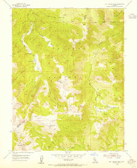
 1896 Pyramid Peak1905 Print · USGSThe high Sierra Nevada backcountry of El Dorado County is captured here in the late nineteenth century, showing a landscape of early trail stops and timber camps. Researchers can trace historic routes to Slippery Ford, find the location of Uncle Toms Cabin, or locate early lakeside destinations like Tallac and Yanks.7 unique versions available
 - 1897 Map of Big Trees
 1897 Big Trees1897 Print · USGSThe Sierra Nevada foothills and deep river canyons of the late nineteenth century are mapped here in detail before modern development. Genealogists and historians can trace early mountain life through landmarks like Bloods Toll, the Riverside Mine, and historic crossings at Abbott Ferry.
 - 1898 Map of Dardanelles
 1898 Dardanelles1898 Print · USGSThe high Sierra Nevada backcountry comes alive in the late 1890s, centered on the canyons of the Stanislaus and West Walker rivers. Trace early high-country travel routes through Sonora Pass or locate historical stops like Baker Station and the meadows of Brightman Flat.8 unique versions available
 - 1901 Map of Big Trees
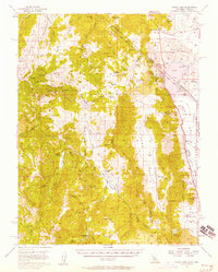
 1901 Big Trees1901 Print · USGSThe High Sierra and Gold Country meet in this turn-of-the-century look at the groves and mining camps of the Mokelumne and Stanislaus watersheds. Trace the early boundaries of the Calaveras Grove, locate the Riverside Mine, or find river crossings like Parrott Ferry.9 unique versions available
 - 1947 Map of Sacramento, 1948 Print
 1947 Sacramento1948 Print · USGSThe Sacramento Valley meets the high Sierra during a period of post-war expansion. Trace the historic river delta islands like Grand Island or locate early airfield footprints at McClellan Air Force Base and Mather Air Force Base.2 unique versions available
 - 1948 Map of Walker Lake
 1948 Walker Lake1948 Print · USGSThe high desert of Nevada and the eastern Sierra Nevada are captured just after the war as mining and ranching shaped the local economy. Genealogists can trace family connections to centers like Hawthorne and Mina or locate the historic Rockland Mines and Aurora.2 unique versions available
 - 1948 Map of Sacramento, 1951 Print
 1948 Sacramento1951 Print · USGSPost-war Northern California comes alive in this regional survey, capturing the era of expansion between the Central Valley and the High Sierra. Researchers can trace the rail networks of the Central California Traction and Sacramento Northern RR or locate landmarks like the State Capitol and University of California Davis.
 - 1954 Map of Pickel Meadow, 1955 Print
 1954 Pickel Meadow1955 Print · USGSThe high Sierra landscape near the Alpine and Mono County line is documented here in the mid-fifties. Researchers can trace the layout of the Marine Corps Cold Weather Camp and locate the historic Leavitt Sta (Site) near Leavitt Meadow.4 unique versions available
 - 1954 Map of Lost Cannon Peak, 1955 Print
 1954 Lost Cannon Peak1955 Print · USGSHigh Sierra grazing grounds and peaks define this mid-1950s survey of the Alpine and Mono County border. Researchers can trace historic seasonal outposts like Connells Cow Camp or explore the rugged drainage of Lost Cannon Creek.5 unique versions available
 - 1955 Map of Echo Lake, 1956 Print
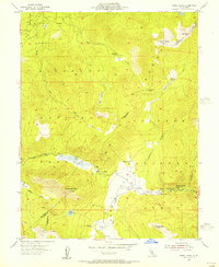
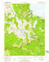
 1955 Echo Lake1956 Print · USGSHigh Sierra recreation and ranching are established across the Eldorado National Forest in the mid-fifties. Researchers can locate the Vade P O at Phillips, trace the old route over Johnson Pass, and find historic sites like Celio Ranch and Camp Sacramento.4 unique versions available
 - 1955 Map of Freel Peak, 1956 Print
 1955 Freel Peak1956 Print · USGSThe high Sierra ridges at the border of El Dorado and Alpine counties come alive in this mid-century survey. Trace old mountain routes and seasonal camps near Luther Pass, from the high waters of Star Lake to the riverside cabins at Sorensens.4 unique versions available
 - 1955 Map of Bijou, 1957 Print
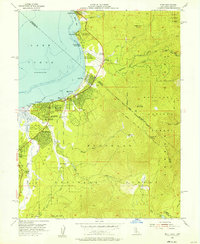 1955 Bijou1957 Print · USGSThe south shore of Lake Tahoe in the mid-fifties shows a burgeoning community of lakefront resorts and mountain camps along the state line. Genealogists and researchers can trace the early development of Stateline, the Sierra House (Site), and Happy Homestead Cemetery.7 unique versions available
 - 1955 Map of Fallen Leaf Lake, 1958 Print
 1955 Fallen Leaf Lake1958 Print · USGSThe Lake Tahoe shoreline and the high Sierra backcountry come alive in this mid-fifties survey of El Dorado County. Researchers can trace the development of legacy resorts and camps at Tallac Village, Camp Richardson, and the historic Celio Ranch.7 unique versions available
 - 1956 Map of Sacramento
 1956 Sacramento1956 Print · USGSMid-century California unfolds from the delta to the high Sierra, capturing a landscape of growing valley cities and burgeoning military airbases. Genealogists and historians can trace the rail lines and river towns from Woodland to Lodi, or explore the foothill settlements of Placerville and Jackson.2 unique versions available
 - 1956 Map of Freel Peak, 1958 Print
 1956 Freel Peak1958 Print · USGSThe South Lake Tahoe region and Carson Valley are shown here in the mid-fifties, just as alpine recreation began to expand. Genealogists and historians can trace family burial sites at Happy Homestead Cemetery or locate early settlements like Sierra House and Dangberg Camp.3 unique versions available
 - 1956 Map of Topaz Lake, 1958 Print
 1956 Topaz Lake1958 Print · USGSThe Sierra Nevada borderlands come alive in the mid-1950s, showing a landscape defined by high-country mining and early mountain transit. Researchers can trace historic state boundaries along the VON SCHMIDT LINE or locate old operations at the Leviathan Mine and Topaz PO.4 unique versions available
Showing maps 1-25 of 176
Top cities of Alpine County
- Alpine Village historical maps
- Mesa Vista historical maps
- Markleeville historical maps
- Bear Valley historical maps
Frequently asked questions
- What are the different types of historical maps available for Alpine County?
- What is the oldest map of Alpine County?
- Where can I purchase historical maps of Alpine County for my home or office?
- Where can I download high-res historical maps of Alpine County?
- Are there historical topographic maps available for Alpine County?
- Is there historical aerial imagery available for Alpine County?
- Where are historical maps of Alpine County sourced from?