1970s Maps of Alpine County, California
Explore 20 historic maps of Alpine County from the 1970s. These maps offer a rare glimpse into what life looked like during the 1970s — showing old roads, neighborhoods, homes, and landmarks that have changed or disappeared over time.
Whether you're researching your family's past, planning a metal detecting trip, or studying how Alpine County's landscape evolved across the 1970s, these high-resolution maps are a powerful tool for exploring the history of this region.
- Focus on a specific era: All maps on this page are from the 1970s, giving you a focused view of this time period.
- See what’s changed: Compare century-old streets, trails, and buildings to today's modern landscape using overlays and satellite layers.
- Research with precision: Use these maps for genealogy, historical research, land use analysis, or educational projects.
- View, download, or print: Maps are fully viewable online in high resolution, and can be downloaded or printed for your own records.
Start exploring Alpine County's history through authentic maps from the 1970s. This is your window into the past.
Alpine County, CA maps
(20)- 1974 Map of Minden
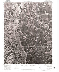 1974 Minden1974 Print · USGSThe Carson Valley is captured in high detail during the mid-1970s, showing the intersection of high-desert agriculture and the winding Carson River. Researchers can trace the development of Minden and the complex irrigation patterns along the East Fork Carson River.
 - 1974 Map of South Lake Tahoe, 1977 Print
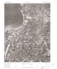 1974 South Lake Tahoe1977 Print · USGSThe California-Nevada border at the lake's southern edge comes into sharp focus during the mid-seventies, showing the density of mountain development. Trace the early layout of South Lake Tahoe and Stateline against the backdrop of the Carson Range.
 - 1976 Map of Placerville, 1994 Print
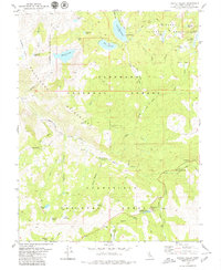
 1976 Placerville1994 Print · USGSEl Dorado County and the high Sierra Nevada are captured in the mid-seventies, showing the evolution of the Mother Lode from its mining roots to a modern recreational and timber hub. Genealogists can locate family names and old landmarks like Old Fort Jim, the Shingle Springs Indian Reservation, and the historic town of Fiddletown.2 unique versions available
 - 1979 Map of Ebbetts Pass
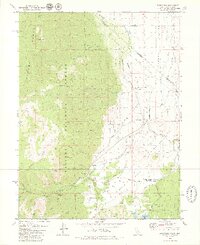
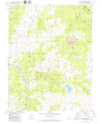
 1979 Ebbetts Pass1979 Print · USGSThe High Sierra mining district near Alpine County comes alive in this late-seventies survey, showing the overlap of old silver claims and modern wilderness trails. Genealogists and historians can trace the locations of the Silver Mountain townsite and numerous mines like the Gould & Curry or the Pennsylvania Mine.4 unique versions available
 - 1979 Map of Woodfords
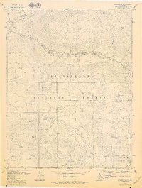
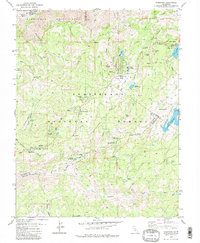
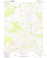
 1979 Woodfords1979 Print · USGSThe high Sierra peaks meet the Nevada border in the late seventies as the West Fork Carson River flows through Alpine County ranching country. Researchers can trace historic land markers like the Von Schmidt Line and Washoe Cem or locate the Snowshoe Thompson Historical Mon.3 unique versions available
 - 1979 Map of Dardanelle
 1979 Dardanelle1979 Print · USGSTuolumne County's High Sierra terrain is captured here in the late 1970s, focused on the river-cut valleys of the Stanislaus National Forest. Researchers can locate historic seasonal outposts and landmarks like Martins Cow Camp, Baker Station, and the Bennett Juniper.3 unique versions available
 - 1979 Map of Wolf Creek
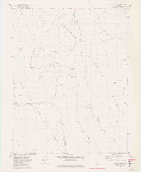
 1979 Wolf Creek1979 Print · USGSAlpine County was a high-country wilderness of deep canyons and pack trails in the late seventies. Researchers can trace the routes between Wolf Creek Camp, the Dixon Mine, and remote outposts like Soda Springs Station.3 unique versions available
 - 1979 Map of Dardanelles Cone
 1979 Dardanelles Cone1979 Print · USGSAlpine and Tuolumne counties in the late 1970s are shown as a high-altitude wilderness shaped by volcanic peaks and recreation. Researchers can trace the Pacific Crest National Scenic Trail past landmarks like Dardanelles Cone and Liahona Camp.2 unique versions available
 - 1979 Map of Pacific Valley
 1979 Pacific Valley1979 Print · USGSHigh in the Sierra Nevada during the late seventies, this survey traces the convergence of three national forests at the Pacific Grade Summit. Researchers can locate remote landmarks like the Stevenot Camp (Site), a lonely Grave, and the Historical Monument near Pacific Valley.2 unique versions available
 - 1979 Map of Heenan Lake
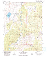
 1979 Heenan Lake1979 Print · USGSAlpine County mining operations are in full view in the late 1970s as industrial sites overlook the East Fork Carson River. Researchers can trace historic claims and trails like Leviathan Mine, the Von Schmidt Line 1872, and the Zaca Mine.3 unique versions available
 - 1979 Map of Tamarack
 1979 Tamarack1979 Print · USGSCalaveras County high country in the late 1970s preserves the intersection of historic pioneer routes and modern wilderness recreation. Researchers can trace the Emigrant Trail, locate the Bloods Toll Sta Hist Site, and find remote outposts like Camp Wolfeboro.2 unique versions available
 - 1979 Map of Carson Pass
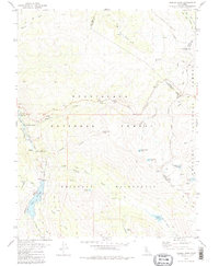
 1979 Carson Pass1979 Print · USGSHigh in the Sierra Nevada during the late seventies, this map captures the intersection of early pioneer history and alpine wilderness. Researchers can trace the legacy of mountain travel through the Snowshoe Thompson-Kit Carson monuments and remote sites like the Alpine Mine or a solitary Grave.3 unique versions available
 - 1979 Map of Donnell Lake
 1979 Donnell Lake1979 Print · USGSTuolumne County's high Sierra landscape is captured here in the late seventies, centered on the Middle Fork Stanislaus River. Genealogists and hikers can locate Wheats Cow Camp and Wagner alongside Donnell Lake.3 unique versions available
 - 1979 Map of Caples Lake, 1980 Print
 1979 Caples Lake1980 Print · USGSHigh Sierra history unfolds in the late seventies as the Kirkwood resort area takes shape alongside legacy pioneer routes. You can trace the Old Emigrant Trail, locate the Lost Cabin Mine, and find seasonal outposts like Schneider Camp.3 unique versions available
 - 1979 Map of Disaster Peak, 1980 Print
 1979 Disaster Peak1980 Print · USGSThe high Sierra Nevada wilderness comes into focus in the late 1970s at the intersection of the Toiyabe and Stanislaus national forests. Hikers and researchers can trace the original route of the Pacific Crest National Scenic Trail past Disaster Peak and the alpine waters of Poison Lake.4 unique versions available
 - 1979 Map of Carters Station, 1980 Print
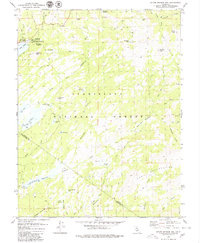
 1979 Carters Station1980 Print · USGSThe high desert along the Nevada-California border appears in the mid-seventies, showcasing the rural landscape of Douglas County. Researchers can trace tribal lands at the Washoe Indian Res (Dresslerville Colony) or locate ranching landmarks like Carters Station and River Ranch.2 unique versions available
 - 1979 Map of Sonora Pass, 1980 Print
 1979 Sonora Pass1980 Print · USGSThe high Sierra crest at the intersection of Tuolumne, Alpine, and Mono Counties is captured here in the late seventies. Researchers can trace historic alpine routes through Sonora Pass, the Pacific Crest National Scenic Trail, and the lone Grave at Chipmunk Flat.2 unique versions available
 - 1979 Map of Mokelumne Peak, 1980 Print
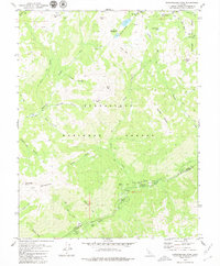
 1979 Mokelumne Peak1980 Print · USGSHigh in the Sierra Nevada during the late seventies, this region was a crossroads of early trails and wilderness camps. Trace the historical footprint of Plasse Trading Post (Site), located near a remote Cem and Grave on Squaw Ridge.3 unique versions available
 - 1979 Map of Markleeville, 1980 Print
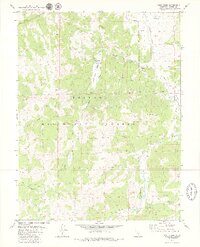
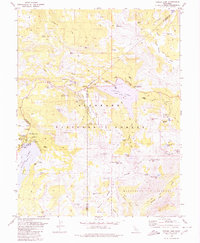
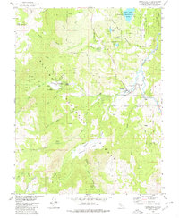 1979 Markleeville1980 Print · USGSMarkleeville and the surrounding Alpine County wilderness are documented here in the late seventies. Researchers can trace the local river-and-road network through Hangmans Bridge, Grover Hot Springs State Park, and the East Fork Carson River.2 unique versions available
 - 1979 Map of Spicer Meadow Res., 1980 Print
 1979 Spicer Meadow Res.1980 Print · USGSHigh Sierra wilderness and water management converge along the Alpine and Tuolumne county line in the late 1970s. Researchers can trace historic pack trails and identify seasonal camps near Lake Alpine, Union Reservoir, and Bull Run Peak.3 unique versions available
End of results
Showing maps 1-20 of 20
Top cities of Alpine County
- Alpine Village historical maps
- Mesa Vista historical maps
- Markleeville historical maps
- Bear Valley historical maps
Frequently asked questions
- What are the different types of historical maps available for Alpine County?
- What is the oldest map of Alpine County?
- Where can I purchase historical maps of Alpine County for my home or office?
- Where can I download high-res historical maps of Alpine County?
- Are there historical topographic maps available for Alpine County?
- Is there historical aerial imagery available for Alpine County?
- Where are historical maps of Alpine County sourced from?