1980s Maps of Alpine County, California
Explore 4 historic maps of Alpine County from the 1980s. These maps offer a rare glimpse into what life looked like during the 1980s — showing old roads, neighborhoods, homes, and landmarks that have changed or disappeared over time.
Whether you're researching your family's past, planning a metal detecting trip, or studying how Alpine County's landscape evolved across the 1980s, these high-resolution maps are a powerful tool for exploring the history of this region.
- Focus on a specific era: All maps on this page are from the 1980s, giving you a focused view of this time period.
- See what’s changed: Compare century-old streets, trails, and buildings to today's modern landscape using overlays and satellite layers.
- Research with precision: Use these maps for genealogy, historical research, land use analysis, or educational projects.
- View, download, or print: Maps are fully viewable online in high resolution, and can be downloaded or printed for your own records.
Start exploring Alpine County's history through authentic maps from the 1980s. This is your window into the past.
Alpine County, CA maps
(4)- 1985 Map of Smith Valley
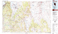 1985 Smith Valley1985 Print · USGSThe Nevada-California borderlands are captured here in the mid-1980s, showcasing the high-desert valleys and Sierra peaks. Trace the mining history at Leviathan Mine or explore the early communities of Minden, Wellington, and the Washoe Indian Res.2 unique versions available
 - 1985 Map of Bridgeport
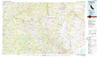 1985 Bridgeport1985 Print · USGSThe High Sierra and Nevada borderlands are captured in the mid-1980s, documenting a landscape of national forests and high-altitude mining districts. Researchers can trace historic operations like the Bodie Mine and May Lundy Mine or locate early settlements at Aurora and Baker Station.
 - 1988 Map of Topaz Lake, 1989 Print
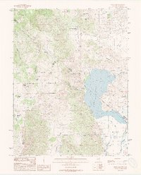 1988 Topaz Lake1989 Print · USGSThe high-desert border between Nevada and California comes alive in this late-eighties survey of Topaz Lake. Genealogists and historians can trace the Von Schmidt Boundary and locate early infrastructure like the Willard-McDonald Mine and Wiley Ditch.2 unique versions available
 - 1988 Map of Coleville, 1989 Print
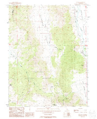 1988 Coleville1989 Print · USGSThe eastern Sierra Nevada and Antelope Valley appear in the late eighties as a landscape of river-fed irrigation and high-mountain mining. Researchers can trace historic water routes like Alkali Ditch and locate landmarks such as the Golden Gate Mine and Coleville.2 unique versions available
End of results
Showing maps 1-4 of 4
Top cities of Alpine County
- Alpine Village historical maps
- Mesa Vista historical maps
- Markleeville historical maps
- Bear Valley historical maps
Frequently asked questions
- What are the different types of historical maps available for Alpine County?
- What is the oldest map of Alpine County?
- Where can I purchase historical maps of Alpine County for my home or office?
- Where can I download high-res historical maps of Alpine County?
- Are there historical topographic maps available for Alpine County?
- Is there historical aerial imagery available for Alpine County?
- Where are historical maps of Alpine County sourced from?