Old Maps of Butte County, California for Academic Research
Study the evolution of Butte County with 375 high-resolution historic maps. Whether you're teaching, researching, or modeling changes in land use, these maps provide essential visual documentation of urban, environmental, and geographic change.
- Analyze long-term change: Track patterns in development, transportation, and natural features.
- Ideal for environmental or urban studies: Support academic projects with primary historical map data.
- Use in the classroom or lab: Educators and researchers rely on these maps to bring historical context to life.
These maps are a powerful tool for teaching, research, and visualizing how Butte County has changed over the decades.
Butte County, CA maps
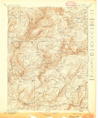
(375)- 1886 Map of Lassen Peak
 1886 Lassen Peak1886 Print · USGSThe Cascades of the late nineteenth century appear here as a landscape of timber mills and volcanic peaks. Genealogists and historians can trace early mountain life at Shingletown, Prattville, and isolated industrial sites like Eureka Mill or the Caribou Bridge.
 - 1888 Map of Marysville
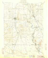
 1888 Marysville1888 Print · USGSThe Sacramento Valley in the late nineteenth century was a landscape of fertile river bottoms and emerging rail towns. Researchers can trace the river economy through Moons Ferry and Eddys Ferry or locate early family holdings like Hock Farm and Butte House.
 - 1888 Map of Smartsville
 1888 Smartsville1888 Print · USGSGold Country was in its industrial prime during the late eighteen-hundreds, with deep-shaft mines and hydraulic camps dotting the Sierra foothills. Researchers can trace early family holdings and mining claims through landmarks like French Corral, the North Star Mine, and the historic settlement of Timbuctoo.
 - 1888 Map of Bidwell Bar, 1956 Print
 1888 Bidwell Bar1956 Print · USGSThe northern Sierra foothills and Feather River canyons come alive in the late nineteenth century before modern reservoirs altered the landscape. Genealogists and researchers can trace family-named sites like Fields Ranch, Spanish Ranch, and Snows Mine.
 - 1891 Map of Bidwell Bar
 1891 Bidwell Bar1891 Print · USGSThe gold-country ridges and deep river canyons of the northern Sierras are shown in the late nineteenth century as mining and timber production shaped the land. Researchers can trace early family-named waystations and industrial sites like American House, Bidwell Bar, and Clipper Mill.
 - 1891 Map of Chico
 1891 Chico1891 Print · USGSUpper Sacramento Valley life in the late nineteenth century revolved around the rail lines and river landings of Chico and Oroville. Genealogists and researchers can trace the early layout of mountain settlements like Magalia and Nimshew or locate old industrial sites including Keefers Old Mill and Doons Mill.
 - 1891 Map of Marysville
 1891 Marysville1891 Print · USGSThe Sacramento Valley in the late nineteenth century centers on the volcanic peaks of the Marysville Buttes. Genealogists and historians can trace pioneer landings and river crossings such as Hock Farm, Princeton Ferry, and the early street grids of Sutter City.
 - 1891 Map of Smartsville
 1891 Smartsville1891 Print · USGSGold Country in the late nineteenth century was a landscape of deep mines and timber rails. This survey allows researchers to trace the industrial footprint of the Idaho and North Star Mine alongside vanished camps like Condemned Bar and French Corral.
 - 1892 Map of Lassen Peak
 1892 Lassen Peak1892 Print · USGSThe volcanic highlands of the southern Cascades are captured in the late nineteenth century, showing early milling and mountain settlements. Genealogists and historians can trace pioneer sites like Prattville, the old Eureka Mill, and the crossings at Caribou Bridge.
 - 1892 Map of Smartsville
 1892 Smartsville1892 Print · USGSThe gold-bearing ridges of the Sierra foothills are captured here in the late nineteenth century, showing the height of the hard-rock mining boom. Researchers can trace the narrow-gauge rail lines and locate famous claims including the Empire Mine, Idaho Mine, and the Sulphuret Works.
 - 1893 Map of Chico
 1893 Chico1893 Print · USGSNorthern California at the height of the nineteenth-century rail and ranching era reveals a network of valley landings and mountain mining camps. Genealogists and historians can trace family locations from Chico to remote spots like Helltown, Old Lovelock, and the Lucretia Mine.
 - 1893 Map of Bidwell Bar
 1893 Bidwell Bar1893 Print · USGSThe Plumas mountains during the late nineteenth century show a landscape defined by gold-era mining and remote stage stops. Genealogists and historians can locate early homesteads and industrial sites like Snows Mine, American House, and Bidwell Bar.
 - 1894 Map of Smartsville
 1894 Smartsville1894 Print · USGSIn the mid-1880s, the Sierra foothills around Nevada City and Grass Valley were a hive of mining and ranching activity. Genealogists and historians can trace old homesteads like Lanes Ranch, follow the Nevada Co Narrow Gauge RR, and locate forgotten camps like Rough & Ready.
 - 1894 Map of Lassen Peak
 1894 Lassen Peak1894 Print · USGSThe volcanic highlands of Northern California are captured here in the 1890s, shortly after the initial topographic surveys. Genealogists and historians can locate early industry and mountain outposts like Eureka Mill, Prattville, and the remote Hat Creek Post Office.8 unique versions available
 - 1894 Map of Marysville
 1894 Marysville1894 Print · USGSThe Sacramento Valley in the 1890s is captured here as a landscape of river ferries and expanding rail lines. Genealogists can trace family footprints in Sutter City, identify old river crossings like Moons Ferry, or locate the historic Hock Farm.
 - 1895 Map of Marysville
 1895 Marysville1895 Print · USGSThe Sacramento Valley in the 1890s centered on the dramatic profile of the Marysville Buttes and a bustling river-and-rail economy. Researchers can trace early river crossings like Moons Ferry, the historic Hock Farm, and the early footprints of Marysville and Yuba City.6 unique versions available
 - 1895 Map of Bidwell Bar
 1895 Bidwell Bar1895 Print · USGSThe Sierra foothills and high ridges of Northern California are captured here in the late nineteenth century. Genealogists and historians can trace isolated waystations and timber camps like American House, Spanish Ranch, and the Old Defiance Mill.
 - 1895 Map of Smartsville
 1895 Smartsville1895 Print · USGSThe Northern Mother Lode thrives during the peak of industrial quartz mining in the late nineteenth century. Researchers can trace the complex rail and mine networks of Nevada City and Grass Valley, alongside historic outposts like Smartsville and Rough & Ready.6 unique versions available
 - 1895 Map of Chico
 1895 Chico1895 Print · USGSNorthern California at the close of the nineteenth century reveals a landscape defined by the Southern Pacific R. R. and early foothill industry. Trace the locations of historic lumber and mining operations like Keefer's Mill, Lucky Jim Mine, and Chapman's Mill.8 unique versions available
 - 1897 Map of Bidwell Bar
 1897 Bidwell Bar1897 Print · USGSThe Sierra Nevada foothills and river canyons come alive in the 1890s as a landscape of remote mines and mountain ranching. Genealogists can trace early homesteads and social hubs like Spanish Ranch, Forbestown, and Old Defiance Mill.7 unique versions available
 - 1904 Map of Vina
 1904 Vina1904 Print · USGSThe Sacramento Valley comes alive in this early century study of the river corridor between Tehama and Butte counties. Trace the rail-and-river economy through the Winery at Vina, the Squaw Hill Ferry, and the planned Lemon Home Colony.3 unique versions available
 - 1906 Map of Willows
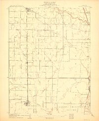 1906 Willows1906 Print · USGSThe northern Sacramento Valley is captured here at the dawn of the irrigation era, centered on the growing railroad hubs of the western plains. Researchers can trace early water infrastructure like the Central Irrigation Canal alongside vanished river landings such as Sidds Ldg and Jacinto.2 unique versions available
 - 1911 Map of Sanborn Slough
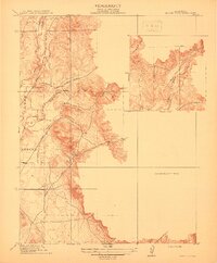
 1911 Sanborn Slough1911 Print · USGSIn the wetlands of the Sacramento Valley before modern flood control, this early century survey captures the seasonal landscape of the Colusa and Butte county lines. Trace the historical hydrology of Butte Sink and find the site of the Harmony School.
 - 1911 Map of Landlow
 1911 Landlow1911 Print · USGSNorthern California's agricultural heartland is captured here in the early twentieth century, showing a landscape defined by new irrigation and transport. Researchers can locate Landlow School and trace the original path of the Cherokee Canal and the Oroville and Butte City Road.
 - 1912 Map of Prairie Creek
 1912 Prairie Creek1912 Print · USGSThe foothills of Yuba and Butte counties come alive in this pre-war survey of the Sacramento Valley’s eastern edge. Genealogists and historians can trace the routes of Bangor Road and locate the historic Salem School and Buckeye School near the banks of Prairie Creek.3 unique versions available
Showing maps 1-25 of 375
Top cities of Butte County
- Chico historical maps
- Oroville historical maps
- Gridley historical maps
- Durham historical maps
- Paradise historical maps
- Biggs historical maps
See more
Frequently asked questions
- What are the different types of historical maps available for Butte County?
- What is the oldest map of Butte County?
- Where can I purchase historical maps of Butte County for my home or office?
- Where can I download high-res historical maps of Butte County?
- Are there historical topographic maps available for Butte County?
- Is there historical aerial imagery available for Butte County?
- Where are historical maps of Butte County sourced from?