1970s Maps of Butte County, California
Explore 13 historic maps of Butte County from the 1970s. These maps offer a rare glimpse into what life looked like during the 1970s — showing old roads, neighborhoods, homes, and landmarks that have changed or disappeared over time.
Whether you're researching your family's past, planning a metal detecting trip, or studying how Butte County's landscape evolved across the 1970s, these high-resolution maps are a powerful tool for exploring the history of this region.
- Focus on a specific era: All maps on this page are from the 1970s, giving you a focused view of this time period.
- See what’s changed: Compare century-old streets, trails, and buildings to today's modern landscape using overlays and satellite layers.
- Research with precision: Use these maps for genealogy, historical research, land use analysis, or educational projects.
- View, download, or print: Maps are fully viewable online in high resolution, and can be downloaded or printed for your own records.
Start exploring Butte County's history through authentic maps from the 1970s. This is your window into the past.
Butte County, CA maps
(13)- 1970 Map of Cherokee, 1973 Print
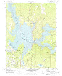
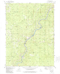
 1970 Cherokee1973 Print · USGSButte County’s transition from mining legacy to reservoir recreation is captured here as the new shoreline of Lake Oroville takes shape. Genealogy and local-history researchers can trace family landmarks like Messilla Valley Sch, the Cherokee Placer Mine, and Yankee Hill.2 unique versions available
 - 1970 Map of Biggs, 1973 Print
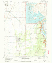 1970 Biggs1973 Print · USGSButte County agriculture is at its height in the early 1970s as massive irrigation projects reshape the Sacramento Valley. Researchers can trace family-named roads and landmarks like the Gridley-Biggs Cemetery, the USDA Rice Experimental Sta, and the shoreline of the Thermalito Afterbay.2 unique versions available
 - 1970 Map of Oroville Dam, 1973 Print
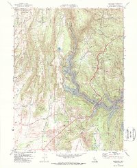
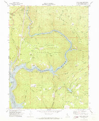
 1970 Oroville Dam1973 Print · USGSButte County in the early seventies shows the massive impact of the Oroville Dam project on the Feather River forks. Genealogists and local historians can trace the new shoreline and recreation sites alongside older landmarks like Hurleton, Lake Wyandotte, and the Bidwell Bar Bridge.2 unique versions available
 - 1970 Map of Oroville, 1973 Print
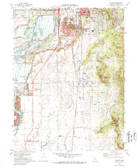
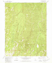
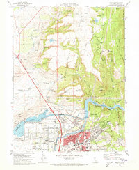 1970 Oroville1973 Print · USGSThe Gold Country meets modern hydro-engineering in Butte County during the early seventies. Trace the evolution of Oroville from its mining roots at Oregon City to the complex water systems of the Thermalito Afterbay and Lake Oroville.2 unique versions available
 - 1970 Map of Palermo, 1973 Print
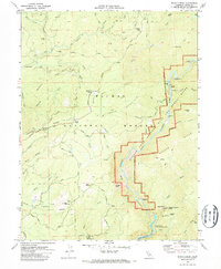
 1970 Palermo1973 Print · USGSButte County saw significant industrial and residential shifts in the early seventies as mining landscapes met expanding suburbs. You can trace the path of the Western Pacific Railroad or locate local landmarks like Lone Tree School and the Oroville Cem.3 unique versions available
 - 1970 Map of Brush Creek, 1973 Print
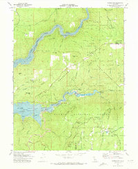
 1970 Brush Creek1973 Print · USGSButte County's rugged foothills are captured here in the early seventies, showing the area as new water projects began to alter the landscape. Genealogists and hikers can trace the Oroville Quincy Road, locate the Berry Creek Rancheria, and find historic sites like Mountain House.2 unique versions available
 - 1970 Map of Berry Creek, 1973 Print
 1970 Berry Creek1973 Print · USGSThe Butte County hills meet the rising waters of the Feather River during the transition to a reservoir-based economy. Researchers can trace the legacy of local mining at the Bunker Hill Mine and follow the old Western Pacific Railroad route.2 unique versions available
 - 1970 Map of Forbestown, 1973 Print
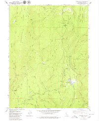
 1970 Forbestown1973 Print · USGSThe foothills of the Sierra Nevada are captured here in the early 1970s as water infrastructure and timber history shape the land. Genealogists and historians can trace Old Forbestown, locate the Gold Bank Mine, or follow the Old Lumpkin Grade Railroad.
 - 1979 Map of Stirling City
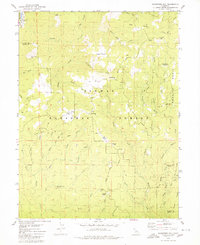
 1979 Stirling City1979 Print · USGSThe timber and mining country of Butte County comes to life in the 1970s as the rail line reaches into the mountains. Researchers can trace the heritage of local camps and cemeteries like Inskip Pioneer Cem, Toadtown, and the Powellton (Site).2 unique versions available
 - 1979 Map of Pulga
 1979 Pulga1979 Print · USGSThe canyon of the North Fork Feather River is shown in detail during the 1970s, highlighting a landscape defined by hydroelectric power and mountain railroading. Trace the Western Pacific line through Tunnel No 11 or locate historic sites like Crain Mill (Site) and Pulga.3 unique versions available
 - 1979 Map of Soapstone Hill, 1980 Print
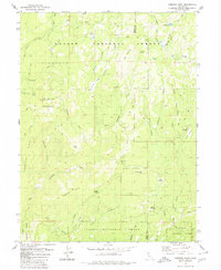
 1979 Soapstone Hill1980 Print · USGSThe Sierra Nevada high country of Plumas County is mapped here during the late seventies, showing a landscape of deep canyons and mining claims. Researchers can locate the Grizzly Dome Tunnel and trace the history of the Soapstone Mine or the former settlement at Merrimac.2 unique versions available
 - 1979 Map of Kimshew Point, 1980 Print
 1979 Kimshew Point1980 Print · USGSUpper Butte and Plumas counties are shown in the late seventies, where the Sierra Nevada terrain is crisscrossed by pack trails and forest service outposts. Researchers can locate remote sites like Campbell Cow Camp, the Snow Mine, and the Lookout Tower atop Bald Mountain.2 unique versions available
 - 1979 Map of Cohasset, 1980 Print
 1979 Cohasset1980 Print · USGSRidge-top life in Butte County during the late seventies is captured here as small communities like Cohasset and Forest Ranch began to expand. Genealogists and researchers can locate the Forest Ranch Cem, the Anderson Mill (Site), and several family landmarks including Spencer Ranch.4 unique versions available
End of results
Showing maps 1-13 of 13
Top cities of Butte County
- Chico historical maps
- Oroville historical maps
- Gridley historical maps
- Durham historical maps
- Paradise historical maps
- Biggs historical maps
See more
Frequently asked questions
- What are the different types of historical maps available for Butte County?
- What is the oldest map of Butte County?
- Where can I purchase historical maps of Butte County for my home or office?
- Where can I download high-res historical maps of Butte County?
- Are there historical topographic maps available for Butte County?
- Is there historical aerial imagery available for Butte County?
- Where are historical maps of Butte County sourced from?