2020s Maps of Butte County, California
Explore 49 historic maps of Butte County from the 2020s. These maps offer a rare glimpse into what life looked like during the 2020s — showing old roads, neighborhoods, homes, and landmarks that have changed or disappeared over time.
Whether you're researching your family's past, planning a metal detecting trip, or studying how Butte County's landscape evolved across the 2020s, these high-resolution maps are a powerful tool for exploring the history of this region.
- Focus on a specific era: All maps on this page are from the 2020s, giving you a focused view of this time period.
- See what’s changed: Compare century-old streets, trails, and buildings to today's modern landscape using overlays and satellite layers.
- Research with precision: Use these maps for genealogy, historical research, land use analysis, or educational projects.
- View, download, or print: Maps are fully viewable online in high resolution, and can be downloaded or printed for your own records.
Start exploring Butte County's history through authentic maps from the 2020s. This is your window into the past.
Butte County, CA maps
(49)- 2021 Map of Berry Creek, 2021 Print
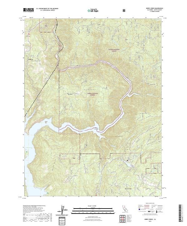 2021 Berry Creek2021 Print · USGSThe Butte County foothills and the Feather River canyon come into focus in the early 2020s. Genealogists and local historians can trace old community sites like Poe, locate the Madrone Cem, and identify historic riverside landings like Island Bar.
 - 2021 Map of Butte City, 2021 Print
 2021 Butte City2021 Print · USGSThe Sacramento River valley in the early 2020s is a landscape defined by its complex waterways and small rural settlements. Researchers can trace family history at Butte City Cem or explore the wetlands around Hoodoo Island and Afton.
 - 2021 Map of Nelson, 2021 Print
 2021 Nelson2021 Print · USGSButte County agriculture and water management are on full display in this early twenty-first-century survey of the Sacramento Valley. Genealogists and local historians can trace the community of Nelson, locate the Nelson Cem, and follow the path of the Western Canal through the valley floor.
 - 2021 Map of Loma Rica, 2021 Print
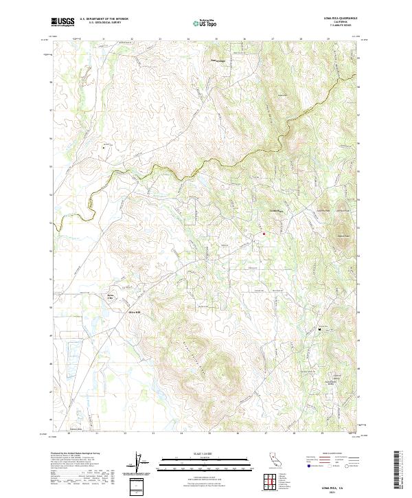 2021 Loma Rica2021 Print · USGSLoma Rica and the Yuba County foothills are shown in detail during the early 2020s, highlighting the area's rural landscape. Researchers can locate Honcut Cem, Peoria Cem, and the historic water routes of Mahle Ditch and Bangor Ditch winding through the hills.
 - 2021 Map of Oregon House, 2021 Print
 2021 Oregon House2021 Print · USGSThe foothills of Yuba County are documented here during a period of modern water management and rural settlement. Researchers can trace the layout of Oregon House, the infrastructure of Merle Collins Reservoir, and local landmarks like the Old Aerodrome.
 - 2021 Map of Chico, 2021 Print
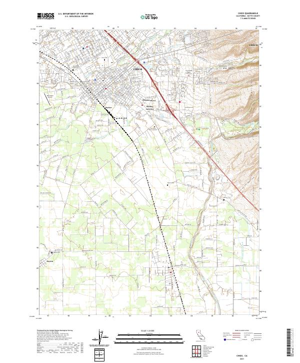 2021 Chico2021 Print · USGSThe northern Sacramento Valley thrives in the early twenty-first century, centered on the growing university town of Chico. Genealogists and historians can trace the foundations of local heritage at the Mechoopda Tribal Cem, Dayton Cem, and the historic industrial hub at Stirling Junction.
 - 2021 Map of Sanborn Slough, 2021 Print
 2021 Sanborn Slough2021 Print · USGSThe wetlands of the Central Sacramento Valley are captured here in the early 2020s, showing the intersection of three counties. Researchers can trace the complex water systems of Butte Sink and follow the route of the Cherokee Canal toward the Sutter Buttes.
 - 2021 Map of Hamlin Canyon, 2021 Print
 2021 Hamlin Canyon2021 Print · USGSThe foothills of Butte County meet the valley floor in the 2020s, revealing a landscape of dramatic ridges and deep canyons. Researchers can trace landforms like Robbers Roost and Beauty Peak alongside modern landmarks such as Butte College.
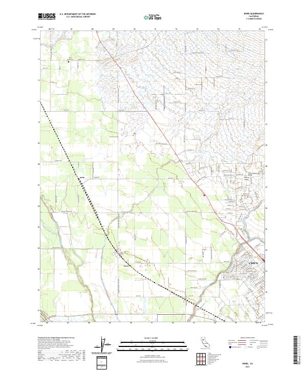
 - 2021 Map of Ord Ferry, 2021 Print
 2021 Ord Ferry2021 Print · USGSThe Sacramento River corridor between Butte and Glenn counties is captured here in detail as it appeared in the early 2020s. Researchers can trace the legacy of early settlements at Monroeville and Ord Ferry, or locate family sites near Pioneer Cem.
 - 2021 Map of Gridley, 2021 Print
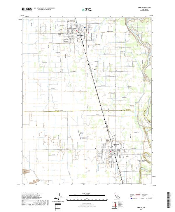 2021 Gridley2021 Print · USGSGridley and Live Oak are captured here in the twenty-first century, documenting the intensive irrigation networks and rail corridors of the Sacramento Valley. Genealogists and researchers can trace local landmarks like Live Oak Cem, Bowles Airport, and the winding Feather River.
 - 2021 Map of American House, 2021 Print
 2021 American House2021 Print · USGSHigh in the Sierra Nevada, this modern survey shows the rugged watersheds of the Plumas National Forest. Researchers can trace historic mining activity at the Sanborn Mine or follow the route of the old Quincy-La Porte Road near Little Grass Valley Reservoir.
 - 2021 Map of Honcut, 2021 Print
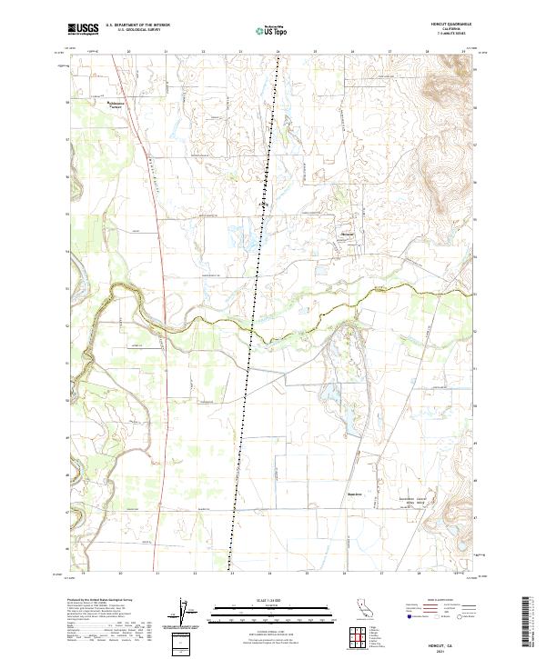 2021 Honcut2021 Print · USGSThe northern Sacramento Valley border comes into focus in this recent survey, showcasing the rural landscapes of Butte and Yuba counties. Genealogists and historians can trace property lines and water rights along Honcut Creek, Wyman Ravine, and the small settlement at Honcut.
 - 2021 Map of Pennington, 2021 Print
 2021 Pennington2021 Print · USGSThe northern edge of the Sutter Buttes meets the Central Valley floor in this recent survey. Researchers can locate the settlement of Pennington and trace historic burials at North Butte Cem and Pugh Cem near the mountain foothills.
 - 2021 Map of Campbell Mound, 2021 Print
 2021 Campbell Mound2021 Print · USGSThe northern Sacramento Valley foothills come alive in the early 2020s, showing a rugged landscape of forest management and volcanic ridges. Trace the heights of Campbell Mound and Sugarloaf Mtn or locate remote sites like Bell Spring.
 - 2021 Map of Oroville Dam, 2021 Print
 2021 Oroville Dam2021 Print · USGSButte County's high country and its massive reservoir are captured here in the early twenty-first century, showing the intersection of modern engineering and gold-country history. Researchers can trace the old names of mining bars and high points like Union Bar, Stringtown Mtn, and Mt Hope.
 - 2021 Map of Paradise West, 2021 Print
 2021 Paradise West2021 Print · USGSButte County canyon country is seen here in recent years, where historic ridge routes and deep creek drainages meet the expanding outskirts of Chico. Researchers can trace old family sites near Helltown, Centerville Cem, and Whiskey Flat.
 - 2021 Map of West of Biggs, 2021 Print
 2021 West of Biggs2021 Print · USGSThe Sacramento Valley south of Richvale appears here as a complex grid of 21st-century agriculture. You can trace the sophisticated irrigation network of the Cherokee Canal and Main Drainage Canal alongside rural landmarks like Williams AG Airport and Richvale Airport.
 - 2021 Map of Nord, 2021 Print
 2021 Nord2021 Print · USGSButte County agriculture and rural life are front and center in this modern survey of the Sacramento Valley. Genealogists and local historians can trace the roads around Nord, find the Pine Creek Cem, and follow the winding course of Keefer Slough.
 - 2021 Map of Cohasset, 2021 Print
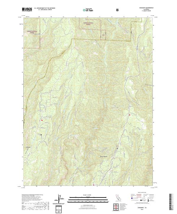 2021 Cohasset2021 Print · USGSRidge-top settlements in the Sierra Nevada foothills flourished along the drainage of Big Chico Cr during the early twenty-first century. Researchers can trace family history at the Cohasset Cem or explore the rugged network of timber and ranch roads along Musty Buck Ridge and Keefer Ridge.
 - 2021 Map of Shippee, 2021 Print
 2021 Shippee2021 Print · USGSThe Sacramento Valley's agricultural heartland is captured here in the early 2020s, showcasing a landscape of complex irrigation. Trace local history through rural hubs like Shippee and Ramada, or follow the engineering of the Cherokee Canal and Western Canal.
 - 2021 Map of Biggs, 2021 Print
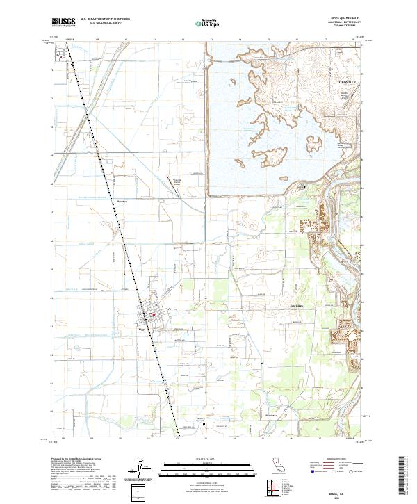 2021 Biggs2021 Print · USGSThe northern Sacramento Valley is captured here in the early twenty-first century, showing a landscape defined by industrial-scale irrigation and rice farming. You can trace local family history through the Old Hamilton Cem or explore the water network of Thermalito Afterbay and Hamilton Slough.
 - 2021 Map of Haskins Valley, 2021 Print
 2021 Haskins Valley2021 Print · USGSThe Plumas National Forest high country around Bucks Lake is shown here in the early twenty-first century. Researchers can trace the path of the Pacific Crest National Scenic Trl or locate the historic Robinson Mine Cem and Hartman Bar.
 - 2021 Map of Strawberry Valley, 2021 Print
 2021 Strawberry Valley2021 Print · USGSThe Sierra Nevada foothills at the meeting of Yuba and Sierra counties come alive in this recent survey. Researchers can locate isolated mountain settlements like Brandy City and Strawberry Valley, as well as historic cemetery sites and the riverside Fosters Bar.
 - 2021 Map of Palermo, 2021 Print
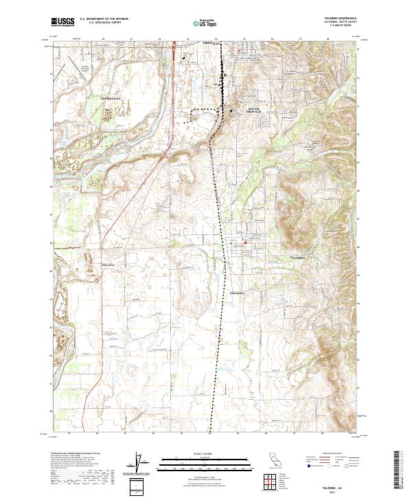 2021 Palermo2021 Print · USGSThe Oroville area and the Feather River corridor are mapped here as they appeared in the early 2020s. Researchers can trace modern residential development and infrastructure through Palermo, Vista Robles, and the Oroville Municipal Airport.
 - 2021 Map of Foster Island, 2021 Print
 2021 Foster Island2021 Print · USGSThe Sacramento River floodplain comes into focus in this contemporary survey, where Tehama, Butte, and Glenn Counties meet. Researchers can trace the intricate river morphology of Foster Island, the family-named Emery and Mitchell Island, and the vital Glenn-Colusa Canal.
Showing maps 1-25 of 49
Top cities of Butte County
- Chico historical maps
- Oroville historical maps
- Gridley historical maps
- Durham historical maps
- Paradise historical maps
- Biggs historical maps
See more
Frequently asked questions
- What are the different types of historical maps available for Butte County?
- What is the oldest map of Butte County?
- Where can I purchase historical maps of Butte County for my home or office?
- Where can I download high-res historical maps of Butte County?
- Are there historical topographic maps available for Butte County?
- Is there historical aerial imagery available for Butte County?
- Where are historical maps of Butte County sourced from?