1910s Maps of Chico, California
Explore 4 historic maps of Chico from the 1910s. These maps offer a rare glimpse into what life looked like during the 1910s — showing old roads, neighborhoods, homes, and landmarks that have changed or disappeared over time.
Whether you're researching your family's past, planning a metal detecting trip, or studying how Chico's landscape evolved across the 1910s, these high-resolution maps are a powerful tool for exploring the history of this region.
- Focus on a specific era: All maps on this page are from the 1910s, giving you a focused view of this time period.
- See what’s changed: Compare century-old streets, trails, and buildings to today's modern landscape using overlays and satellite layers.
- Research with precision: Use these maps for genealogy, historical research, land use analysis, or educational projects.
- View, download, or print: Maps are fully viewable online in high resolution, and can be downloaded or printed for your own records.
Start exploring Chico's history through authentic maps from the 1910s. This is your window into the past.
Chico, CA maps
(4)- 1912 Map of Durham
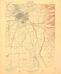 1912 Durham1912 Print · USGSNorthern Sacramento Valley industry and agriculture thrive in the decade before the Great War. Genealogists can trace the early streets of Chico, the worker housing at Barber, and rural schools like York School near the Diamond Match Factory.
 - 1912 Map of Nord
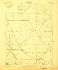 1912 Nord1912 Print · USGSThe northern Sacramento Valley thrived as a rail-dependent agricultural corridor in the early twentieth century. Genealogists can trace early homesteads near the Southern Pacific RR and locate rural landmarks like Antelope School and Cana.2 unique versions available
 - 1912 Map of Chico Landing
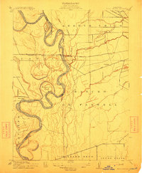 1912 Chico Landing1912 Print · USGSThe Sacramento River corridor near Butte County was a landscape of winding sloughs and emerging rail lines in the early twentieth century. Researchers can trace the footprints of riverside settlements like Munroeville, find old schools such as River Road School, and locate historical crossings of the Northern Electric RR.2 unique versions available
 - 1912 Map of Keefers
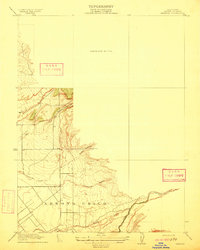 1912 Keefers1912 Print · USGSButte County land and water rights are visible in high detail on this 1912 preliminary survey of the northern Central Valley. Genealogists and land researchers can trace the early drainage and ranching terrain along Arroyo Chico, Mud Creek, and Sycamore Creek.2 unique versions available
End of results
Showing maps 1-4 of 4
Top cities near Chico
Top neighborhoods of Chico
- Stirling Junction historical maps
- Barber historical maps
- Chapmantown historical maps
- City Plaza historical maps
- No sidewalk riding district historical maps
Frequently asked questions
- What are the different types of historical maps available for Chico?
- What is the oldest map of Chico?
- Where can I purchase historical maps of Chico for my home or office?
- Where can I download high-res historical maps of Chico?
- Are there historical topographic maps available for Chico?
- Is there historical aerial imagery available for Chico?
- Where are historical maps of Chico sourced from?