1980s Maps of Paradise, California
Explore 3 historic maps of Paradise from the 1980s. These maps offer a rare glimpse into what life looked like during the 1980s — showing old roads, neighborhoods, homes, and landmarks that have changed or disappeared over time.
Whether you're researching your family's past, planning a metal detecting trip, or studying how Paradise's landscape evolved across the 1980s, these high-resolution maps are a powerful tool for exploring the history of this region.
- Focus on a specific era: All maps on this page are from the 1980s, giving you a focused view of this time period.
- See what’s changed: Compare century-old streets, trails, and buildings to today's modern landscape using overlays and satellite layers.
- Research with precision: Use these maps for genealogy, historical research, land use analysis, or educational projects.
- View, download, or print: Maps are fully viewable online in high resolution, and can be downloaded or printed for your own records.
Start exploring Paradise's history through authentic maps from the 1980s. This is your window into the past.
Paradise, CA maps
(3)- 1980 Map of Chico
 1980 Chico1980 Print · USGSButte County and the Sierra foothills are shown here in the 1980s as the region's water and timber economies matured. Genealogists and researchers can trace old land grants like Rancho Capay or locate mountain mining sites and settlements such as Cherokee, Magalia, and the Big Bend Mine.2 unique versions available
 - 1980 Map of Paradise East
 1980 Paradise East1980 Print · USGSButte County communities like Magalia and Paradise are shown in detail during the 1970s and 1980s. Genealogists and researchers can locate old mining sites like the Steifer Mine, the Historic Pioneer Church, and the former settlement of Irish Town.
 - 1980 Map of Paradise West
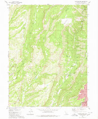 1980 Paradise West1980 Print · USGSButte County's high ridges and deep canyons come into focus in the early eighties as residential growth reaches the Paradise area. Trace old foothill settlements and mining era relics like Helltown, Irish Town, and the Indian Spring Mine.4 unique versions available
End of results
Showing maps 1-3 of 3
Top cities near Paradise
Frequently asked questions
- What are the different types of historical maps available for Paradise?
- What is the oldest map of Paradise?
- Where can I purchase historical maps of Paradise for my home or office?
- Where can I download high-res historical maps of Paradise?
- Are there historical topographic maps available for Paradise?
- Is there historical aerial imagery available for Paradise?
- Where are historical maps of Paradise sourced from?