1950s Maps of Paradise, California
Explore 3 historic maps of Paradise from the 1950s. These maps offer a rare glimpse into what life looked like during the 1950s — showing old roads, neighborhoods, homes, and landmarks that have changed or disappeared over time.
Whether you're researching your family's past, planning a metal detecting trip, or studying how Paradise's landscape evolved across the 1950s, these high-resolution maps are a powerful tool for exploring the history of this region.
- Focus on a specific era: All maps on this page are from the 1950s, giving you a focused view of this time period.
- See what’s changed: Compare century-old streets, trails, and buildings to today's modern landscape using overlays and satellite layers.
- Research with precision: Use these maps for genealogy, historical research, land use analysis, or educational projects.
- View, download, or print: Maps are fully viewable online in high resolution, and can be downloaded or printed for your own records.
Start exploring Paradise's history through authentic maps from the 1950s. This is your window into the past.
Paradise, CA maps
(3)- 1951 Map of Hamlin Canyon, 1952 Print
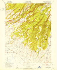 1951 Hamlin Canyon1952 Print · USGSThe foothills of Butte County are shown in the early fifties as the community of Paradise expanded along the ridgelines. Researchers can trace historical sites like the Clear Creek Sch (Aband), the Elliot Spring House, and geographic landmarks such as Robbers Roost.5 unique versions available
 - 1953 Map of Paradise, 1955 Print
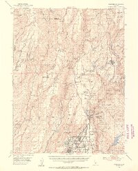 1953 Paradise1955 Print · USGSButte County ridge life and the Sierra Nevada foothills are documented here in the early fifties, before the region's massive modern growth. Genealogists and historians can trace the foundations of Paradise and locate historic spots like Nimshew, the Magalia Mine, and the Southern Pacific line to Stirling City.5 unique versions available
 - 1958 Map of Chico, 1962 Print
 1958 Chico1962 Print · USGSMid-century Northern California comes to life across the Central Valley and high Sierras as the postwar economy transformed the landscape. Trace the rail lines of the Southern Pacific RR, locate family roots near Chico Cem, or explore the early layout of Paradise and Beale Air Force Base.4 unique versions available
End of results
Showing maps 1-3 of 3
Top cities near Paradise
Frequently asked questions
- What are the different types of historical maps available for Paradise?
- What is the oldest map of Paradise?
- Where can I purchase historical maps of Paradise for my home or office?
- Where can I download high-res historical maps of Paradise?
- Are there historical topographic maps available for Paradise?
- Is there historical aerial imagery available for Paradise?
- Where are historical maps of Paradise sourced from?