1910s Maps of Colusa, California
Explore 2 historic maps of Colusa from the 1910s. These maps offer a rare glimpse into what life looked like during the 1910s — showing old roads, neighborhoods, homes, and landmarks that have changed or disappeared over time.
Whether you're researching your family's past, planning a metal detecting trip, or studying how Colusa's landscape evolved across the 1910s, these high-resolution maps are a powerful tool for exploring the history of this region.
- Focus on a specific era: All maps on this page are from the 1910s, giving you a focused view of this time period.
- See what’s changed: Compare century-old streets, trails, and buildings to today's modern landscape using overlays and satellite layers.
- Research with precision: Use these maps for genealogy, historical research, land use analysis, or educational projects.
- View, download, or print: Maps are fully viewable online in high resolution, and can be downloaded or printed for your own records.
Start exploring Colusa's history through authentic maps from the 1910s. This is your window into the past.
Colusa, CA maps
(2)- 1912 Map of Meridian
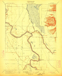 1912 Meridian1912 Print · USGSThe Sacramento Valley riverlands and the western foothills of the volcanic buttes are captured here just before the era of modern levee and bypass systems. You can locate rural schoolhouses like Farmers School and trace the early boundaries of Butte Sink and the town of Meridian.2 unique versions available
 - 1918 Map of Powell Slough
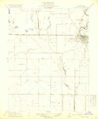 1918 Powell Slough1918 Print · USGSThe Sacramento Valley's agricultural heart is captured here as the Great War ended, centered on the river town of Colusa. Trace the early irrigation works of the Colusa and Lake Irrigation Company Canal and family-named landmarks like Powell Slough.2 unique versions available
End of results
Showing maps 1-2 of 2
Top cities near Colusa
Top neighborhoods of Colusa
Frequently asked questions
- What are the different types of historical maps available for Colusa?
- What is the oldest map of Colusa?
- Where can I purchase historical maps of Colusa for my home or office?
- Where can I download high-res historical maps of Colusa?
- Are there historical topographic maps available for Colusa?
- Is there historical aerial imagery available for Colusa?
- Where are historical maps of Colusa sourced from?