1990s Maps of Colusa, California
Explore 3 historic maps of Colusa from the 1990s. These maps offer a rare glimpse into what life looked like during the 1990s — showing old roads, neighborhoods, homes, and landmarks that have changed or disappeared over time.
Whether you're researching your family's past, planning a metal detecting trip, or studying how Colusa's landscape evolved across the 1990s, these high-resolution maps are a powerful tool for exploring the history of this region.
- Focus on a specific era: All maps on this page are from the 1990s, giving you a focused view of this time period.
- See what’s changed: Compare century-old streets, trails, and buildings to today's modern landscape using overlays and satellite layers.
- Research with precision: Use these maps for genealogy, historical research, land use analysis, or educational projects.
- View, download, or print: Maps are fully viewable online in high resolution, and can be downloaded or printed for your own records.
Start exploring Colusa's history through authentic maps from the 1990s. This is your window into the past.
Colusa, CA maps
(3)- 1991 Map of Colusa, 1995 Print
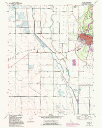 1991 Colusa1995 Print · USGSColusa and the Sacramento River bottomlands are captured here in the early nineties, showing a landscape defined by levees and wildlife conservation. Researchers can trace the town grid to find Union High Sch and St Johns Ch, or follow the Old Railroad Grade past the County Fairgrounds.
 - 1993 Map of Yuba City, 1994 Print
 1993 Yuba City1994 Print · USGSThe Sacramento Valley and Sierra Nevada foothills meet in the 1990s, where agricultural bypasses and river networks surround the iconic Sutter Buttes. Researchers can trace the rail corridors of the Southern Pacific and Western Pacific through hubs like Marysville and Gridley.
 - 1994 Map of Lakeport
 1994 Lakeport1994 Print · USGSCoastal mountains meet the fertile Sacramento Valley in the 1990s, where the waters of Clear Lake define the western landscape. Researchers can trace the industrial footprint of the Sulphur Bank Mine, follow the Southern Pacific RR tracks, or locate old settlements like Fouts Springs and Lodoga.
End of results
Showing maps 1-3 of 3
Top cities near Colusa
Top neighborhoods of Colusa
Frequently asked questions
- What are the different types of historical maps available for Colusa?
- What is the oldest map of Colusa?
- Where can I purchase historical maps of Colusa for my home or office?
- Where can I download high-res historical maps of Colusa?
- Are there historical topographic maps available for Colusa?
- Is there historical aerial imagery available for Colusa?
- Where are historical maps of Colusa sourced from?