1900s (20th Century) Maps of Butte City, California
Explore 7 historic maps of Butte City from the 1900s (20th Century). These maps offer a rare glimpse into what life looked like during the 1900s — showing old roads, neighborhoods, homes, and landmarks that have changed or disappeared over time.
Whether you're researching your family's past, planning a metal detecting trip, or studying how Butte City's landscape evolved across the 1900s, these high-resolution maps are a powerful tool for exploring the history of this region.
- Focus on a specific era: All maps on this page are from the 1900s, giving you a focused view of this time period.
- See what’s changed: Compare century-old streets, trails, and buildings to today's modern landscape using overlays and satellite layers.
- Research with precision: Use these maps for genealogy, historical research, land use analysis, or educational projects.
- View, download, or print: Maps are fully viewable online in high resolution, and can be downloaded or printed for your own records.
Start exploring Butte City's history through authentic maps from the 1900s. This is your window into the past.
Butte City, CA maps
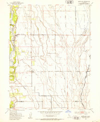
(7)- 1912 Map of Butte City
 1912 Butte City1912 Print · USGSThe Sacramento River and its complex system of sloughs dominate this Glenn County landscape in the years before intensive irrigation. Trace family roots at Marvin Chapel or locate old school sites like Carson School and Union School.
 - 1942 Map of Butte Sink
 1942 Butte Sink1942 Print · USGSNorthern California's agricultural heartland is documented here during the early war years, showing the intersection of four counties. Researchers can locate family landmarks like Marvin Chapel and trace the rural school system at Harmony Sch and Butte Sch.
 - 1952 Map of Butte City, 1953 Print
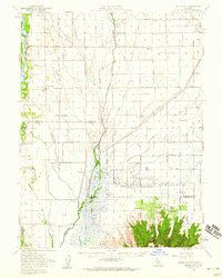
 1952 Butte City1953 Print · USGSGlenn County agriculture and flood control are in focus during the early fifties as the river plains transition into managed farmland. Genealogists can trace family footprints at Butte City Cemetery, Afton, and the local Union Sch.4 unique versions available
 - 1954 Map of Butte City, 1959 Print
 1954 Butte City1959 Print · USGSThe Sacramento Valley in the mid-fifties is captured here during a period of intensive water management and rural growth. Genealogists can locate family landmarks like Butte City Cem, Union School, and several established properties including Schohr Ranch.2 unique versions available
 - 1958 Map of Chico, 1962 Print
 1958 Chico1962 Print · USGSMid-century Northern California comes to life across the Central Valley and high Sierras as the postwar economy transformed the landscape. Trace the rail lines of the Southern Pacific RR, locate family roots near Chico Cem, or explore the early layout of Paradise and Beale Air Force Base.4 unique versions available
 - 1960 Map of Chico
 1960 Chico1960 Print · USGSThe Northern California high country and Sacramento Valley meet in this 1960s-era landscape of mining towns and river settlements. Trace the rail-and-water economy of the gold country through the Empire Mine, Beale Air Force Base, and the Western Pacific Railroad.
 - 1993 Map of Yuba City, 1994 Print
 1993 Yuba City1994 Print · USGSThe Sacramento Valley and Sierra Nevada foothills meet in the 1990s, where agricultural bypasses and river networks surround the iconic Sutter Buttes. Researchers can trace the rail corridors of the Southern Pacific and Western Pacific through hubs like Marysville and Gridley.
End of results
Showing maps 1-7 of 7
Top cities near Butte City
Frequently asked questions
- What are the different types of historical maps available for Butte City?
- What is the oldest map of Butte City?
- Where can I purchase historical maps of Butte City for my home or office?
- Where can I download high-res historical maps of Butte City?
- Are there historical topographic maps available for Butte City?
- Is there historical aerial imagery available for Butte City?
- Where are historical maps of Butte City sourced from?