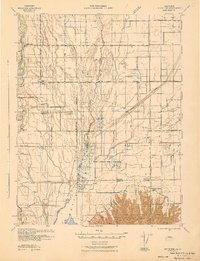
1942 Map of Butte Sink
USGS Topo · Published 1942About this map
The Sacramento River defines the western edge of this wartime survey, which captures a complex network of sloughs and irrigation features in the heart of the Central Valley. Centered on the Grey Lodge Game Refuge, the landscape is dominated by the northern slopes of the Marysville Buttes, rising abruptly from the surrounding flats. The map serves as a vital record for genealogists, documenting rural life through features like Marvin Chapel and small educational centers including Union Sch, Harmony Sch, and Butte Sch.
Find a feature on this map
22 named features on this map. Tap any name to fly to it.
Don’t see what you’re looking for? This feature index may not catch every label — zoom into the map to look around manually.
Map Details
Editions of this 1942 Butte Sink Map
This is the sole edition of this map. No revisions or reprints were ever made.
Other maps of this area

1888 · Marysville
USGS Topo · 1:125,000

1891 · Chico
USGS Topo · 1:125,000

1891 · Marysville
USGS Topo · 1:125,000

1893 · Chico
USGS Topo · 1:125,000

1894 · Marysville
USGS Topo · 1:125,000

1895 · Marysville
USGS Topo · 1:125,000

1895 · Chico
USGS Topo · 1:125,000

1906 · Maxwell
USGS Topo · 1:62,500

1906 · Willows
USGS Topo · 1:62,500

1907 · Colusa
USGS Topo · 1:62,500