1940s Maps of Hamilton City, California
Explore 3 historic maps of Hamilton City from the 1940s. These maps offer a rare glimpse into what life looked like during the 1940s — showing old roads, neighborhoods, homes, and landmarks that have changed or disappeared over time.
Whether you're researching your family's past, planning a metal detecting trip, or studying how Hamilton City's landscape evolved across the 1940s, these high-resolution maps are a powerful tool for exploring the history of this region.
- Focus on a specific era: All maps on this page are from the 1940s, giving you a focused view of this time period.
- See what’s changed: Compare century-old streets, trails, and buildings to today's modern landscape using overlays and satellite layers.
- Research with precision: Use these maps for genealogy, historical research, land use analysis, or educational projects.
- View, download, or print: Maps are fully viewable online in high resolution, and can be downloaded or printed for your own records.
Start exploring Hamilton City's history through authentic maps from the 1940s. This is your window into the past.
Hamilton City, CA maps
(3)- 1949 Map of Chico, 1953 Print
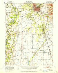 1949 Chico1953 Print · USGSMid-century Butte County thrives along the river and rail, from the academic center of Chico to the agricultural hubs of Durham and Nelson. Genealogists and researchers can trace local landmarks like Chico Cem, the Match Factory, and the Sacramento Northern railroad.3 unique versions available
 - 1949 Map of Ord Ferry, 1957 Print
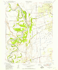 1949 Ord Ferry1957 Print · USGSThe Sacramento River valley at mid-century reveals a landscape of historic land grants and shifting river channels. Genealogists and researchers can trace local landmarks like Bidwell Sch, the Chico Landing site, and the river crossing at Ord Ferry.3 unique versions available
 - 1949 Map of Hamilton City, 1958 Print
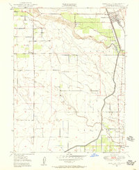 1949 Hamilton City1958 Print · USGSHamilton City and the Sacramento Valley riverlands are captured here at the end of the 1940s. Genealogists and researchers can trace the rural communities of Ordbend and St John (Site) alongside the Southern Pacific tracks and local schoolhouses like Ord School.3 unique versions available
End of results
Showing maps 1-3 of 3
Top cities near Hamilton City
- Chico historical maps
- Corning historical maps
- Willows historical maps
- Durham historical maps
- Vina historical maps
Frequently asked questions
- What are the different types of historical maps available for Hamilton City?
- What is the oldest map of Hamilton City?
- Where can I purchase historical maps of Hamilton City for my home or office?
- Where can I download high-res historical maps of Hamilton City?
- Are there historical topographic maps available for Hamilton City?
- Is there historical aerial imagery available for Hamilton City?
- Where are historical maps of Hamilton City sourced from?