1900s (20th Century) Maps of Hamilton City, California
Explore 15 historic maps of Hamilton City from the 1900s (20th Century). These maps offer a rare glimpse into what life looked like during the 1900s — showing old roads, neighborhoods, homes, and landmarks that have changed or disappeared over time.
Whether you're researching your family's past, planning a metal detecting trip, or studying how Hamilton City's landscape evolved across the 1900s, these high-resolution maps are a powerful tool for exploring the history of this region.
- Focus on a specific era: All maps on this page are from the 1900s, giving you a focused view of this time period.
- See what’s changed: Compare century-old streets, trails, and buildings to today's modern landscape using overlays and satellite layers.
- Research with precision: Use these maps for genealogy, historical research, land use analysis, or educational projects.
- View, download, or print: Maps are fully viewable online in high resolution, and can be downloaded or printed for your own records.
Start exploring Hamilton City's history through authentic maps from the 1900s. This is your window into the past.
Hamilton City, CA maps
(15)- 1906 Map of Willows
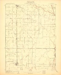 1906 Willows1906 Print · USGSThe northern Sacramento Valley is captured here at the dawn of the irrigation era, centered on the growing railroad hubs of the western plains. Researchers can trace early water infrastructure like the Central Irrigation Canal alongside vanished river landings such as Sidds Ldg and Jacinto.2 unique versions available
 - 1912 Map of Chico Landing
 1912 Chico Landing1912 Print · USGSThe Sacramento River corridor near Butte County was a landscape of winding sloughs and emerging rail lines in the early twentieth century. Researchers can trace the footprints of riverside settlements like Munroeville, find old schools such as River Road School, and locate historical crossings of the Northern Electric RR.2 unique versions available
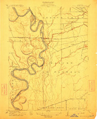
 - 1914 Map of Hamilton
 1914 Hamilton1914 Print · USGSNorthern Glenn County comes into focus in this early twentieth-century survey of the Sacramento Valley's emerging agricultural landscape. Trace the tracks of the S P R R and Northern El R R as they converge near Hamilton and the Swift Point Warehouse.
 - 1949 Map of Chico, 1953 Print
 1949 Chico1953 Print · USGSMid-century Butte County thrives along the river and rail, from the academic center of Chico to the agricultural hubs of Durham and Nelson. Genealogists and researchers can trace local landmarks like Chico Cem, the Match Factory, and the Sacramento Northern railroad.3 unique versions available
 - 1949 Map of Ord Ferry, 1957 Print
 1949 Ord Ferry1957 Print · USGSThe Sacramento River valley at mid-century reveals a landscape of historic land grants and shifting river channels. Genealogists and researchers can trace local landmarks like Bidwell Sch, the Chico Landing site, and the river crossing at Ord Ferry.3 unique versions available
 - 1949 Map of Hamilton City, 1958 Print
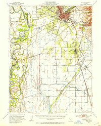
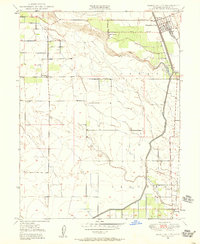 1949 Hamilton City1958 Print · USGSHamilton City and the Sacramento Valley riverlands are captured here at the end of the 1940s. Genealogists and researchers can trace the rural communities of Ordbend and St John (Site) alongside the Southern Pacific tracks and local schoolhouses like Ord School.3 unique versions available
 - 1950 Map of Hamilton City
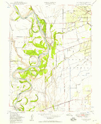
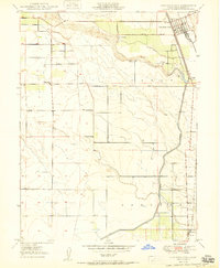 1950 Hamilton City1950 Print · USGSAgricultural Glenn County comes to life at mid-century, centered on the rail-fed hub of Hamilton City. Genealogists and historians can trace old homesteads and local institutions like Union High Sch, Ordbend, and the historic St John (Site).
 - 1950 Map of Ord Ferry
 1950 Ord Ferry1950 Print · USGSThe Sacramento River bottomlands near the Butte and Glenn county line come into focus just after the war. Local historians can trace early valley river life through sites like Ord Ferry, the Bidwell Sch, and the historical site of Chico Landing.
 - 1951 Map of Willows, 1959 Print
 1951 Willows1959 Print · USGSIn the early fifties, Glenn County was a thriving network of orchards and rail-side towns. Genealogists and historians can trace the foundations of Willows and Hamilton City, while locating rural landmarks like Artois Cemetery and Jacinto Grange.
 - 1957 Map of Ukiah, 1966 Print
 1957 Ukiah1966 Print · USGSNorthern California's diverse terrain comes into focus in the mid-1950s, from the rugged timberlands of the Jackson State Forest to the productive Sacramento Valley. Genealogists and historians can trace the rail lines of the Northwestern Pacific or locate early valley settlements like Arbuckle and Paskenta.3 unique versions available
 - 1958 Map of Chico, 1962 Print
 1958 Chico1962 Print · USGSMid-century Northern California comes to life across the Central Valley and high Sierras as the postwar economy transformed the landscape. Trace the rail lines of the Southern Pacific RR, locate family roots near Chico Cem, or explore the early layout of Paradise and Beale Air Force Base.4 unique versions available
 - 1960 Map of Ukiah
 1960 Ukiah1960 Print · USGSNorthern California during the late fifties reveals a landscape of deep timber forests and valley agriculture before modern expansion. Trace the historic rail lines of the California Western RR and the Northwestern Pacific RR through settlements like Fort Bragg and Ukiah.2 unique versions available
 - 1960 Map of Chico
 1960 Chico1960 Print · USGSThe Northern California high country and Sacramento Valley meet in this 1960s-era landscape of mining towns and river settlements. Trace the rail-and-water economy of the gold country through the Empire Mine, Beale Air Force Base, and the Western Pacific Railroad.
 - 1980 Map of Chico
 1980 Chico1980 Print · USGSButte County and the Sierra foothills are shown here in the 1980s as the region's water and timber economies matured. Genealogists and researchers can trace old land grants like Rancho Capay or locate mountain mining sites and settlements such as Cherokee, Magalia, and the Big Bend Mine.2 unique versions available
 - 1987 Map of Willows, 1988 Print
 1987 Willows1988 Print · USGSThe northern Sacramento Valley meets the Coast Range in the late eighties, showing a landscape defined by water and transit. Researchers can trace the Southern Pacific railroad past Artois and Corning, or locate family-named landmarks like Larkins Childrens Rancho and Snaden Island.2 unique versions available
End of results
Showing maps 1-15 of 15
Top cities near Hamilton City
- Chico historical maps
- Corning historical maps
- Willows historical maps
- Durham historical maps
- Vina historical maps
Frequently asked questions
- What are the different types of historical maps available for Hamilton City?
- What is the oldest map of Hamilton City?
- Where can I purchase historical maps of Hamilton City for my home or office?
- Where can I download high-res historical maps of Hamilton City?
- Are there historical topographic maps available for Hamilton City?
- Is there historical aerial imagery available for Hamilton City?
- Where are historical maps of Hamilton City sourced from?