1950s Maps of Hamilton City, California
Explore 5 historic maps of Hamilton City from the 1950s. These maps offer a rare glimpse into what life looked like during the 1950s — showing old roads, neighborhoods, homes, and landmarks that have changed or disappeared over time.
Whether you're researching your family's past, planning a metal detecting trip, or studying how Hamilton City's landscape evolved across the 1950s, these high-resolution maps are a powerful tool for exploring the history of this region.
- Focus on a specific era: All maps on this page are from the 1950s, giving you a focused view of this time period.
- See what’s changed: Compare century-old streets, trails, and buildings to today's modern landscape using overlays and satellite layers.
- Research with precision: Use these maps for genealogy, historical research, land use analysis, or educational projects.
- View, download, or print: Maps are fully viewable online in high resolution, and can be downloaded or printed for your own records.
Start exploring Hamilton City's history through authentic maps from the 1950s. This is your window into the past.
Hamilton City, CA maps
(5)- 1950 Map of Hamilton City
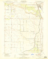 1950 Hamilton City1950 Print · USGSAgricultural Glenn County comes to life at mid-century, centered on the rail-fed hub of Hamilton City. Genealogists and historians can trace old homesteads and local institutions like Union High Sch, Ordbend, and the historic St John (Site).
 - 1950 Map of Ord Ferry
 1950 Ord Ferry1950 Print · USGSThe Sacramento River bottomlands near the Butte and Glenn county line come into focus just after the war. Local historians can trace early valley river life through sites like Ord Ferry, the Bidwell Sch, and the historical site of Chico Landing.
 - 1951 Map of Willows, 1959 Print
 1951 Willows1959 Print · USGSIn the early fifties, Glenn County was a thriving network of orchards and rail-side towns. Genealogists and historians can trace the foundations of Willows and Hamilton City, while locating rural landmarks like Artois Cemetery and Jacinto Grange.
 - 1957 Map of Ukiah, 1966 Print
 1957 Ukiah1966 Print · USGSNorthern California's diverse terrain comes into focus in the mid-1950s, from the rugged timberlands of the Jackson State Forest to the productive Sacramento Valley. Genealogists and historians can trace the rail lines of the Northwestern Pacific or locate early valley settlements like Arbuckle and Paskenta.3 unique versions available
 - 1958 Map of Chico, 1962 Print
 1958 Chico1962 Print · USGSMid-century Northern California comes to life across the Central Valley and high Sierras as the postwar economy transformed the landscape. Trace the rail lines of the Southern Pacific RR, locate family roots near Chico Cem, or explore the early layout of Paradise and Beale Air Force Base.4 unique versions available
End of results
Showing maps 1-5 of 5
Top cities near Hamilton City
- Chico historical maps
- Corning historical maps
- Willows historical maps
- Durham historical maps
- Vina historical maps
Frequently asked questions
- What are the different types of historical maps available for Hamilton City?
- What is the oldest map of Hamilton City?
- Where can I purchase historical maps of Hamilton City for my home or office?
- Where can I download high-res historical maps of Hamilton City?
- Are there historical topographic maps available for Hamilton City?
- Is there historical aerial imagery available for Hamilton City?
- Where are historical maps of Hamilton City sourced from?