1970s Maps of Lone Pine, California
Explore 3 historic maps of Lone Pine from the 1970s. These maps offer a rare glimpse into what life looked like during the 1970s — showing old roads, neighborhoods, homes, and landmarks that have changed or disappeared over time.
Whether you're researching your family's past, planning a metal detecting trip, or studying how Lone Pine's landscape evolved across the 1970s, these high-resolution maps are a powerful tool for exploring the history of this region.
- Focus on a specific era: All maps on this page are from the 1970s, giving you a focused view of this time period.
- See what’s changed: Compare century-old streets, trails, and buildings to today's modern landscape using overlays and satellite layers.
- Research with precision: Use these maps for genealogy, historical research, land use analysis, or educational projects.
- View, download, or print: Maps are fully viewable online in high resolution, and can be downloaded or printed for your own records.
Start exploring Lone Pine's history through authentic maps from the 1970s. This is your window into the past.
Lone Pine, CA maps
(3)- 1975 Map of Lone Pine NE, 1979 Print
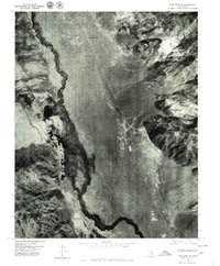 1975 Lone Pine NE1979 Print · USGSOwens Valley comes into sharp focus during the mid-seventies, showing the intersection of natural waterways and major infrastructure. Researchers can trace the layout of Manzanar, the course of the Owens River, and the path of the Los Angeles Aqueduct.
 - 1975 Map of Lone Pine SE, 1979 Print
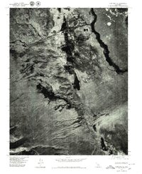 1975 Lone Pine SE1979 Print · USGSThe Owens Valley landscape and the settlement of Lone Pine are captured in this mid-seventies aerial survey. Researchers can trace the path of the Los Angeles Aqueduct and the stark expanse of the Owens Lake bed.2 unique versions available
 - 1978 Map of Mount Whitney, 1992 Print
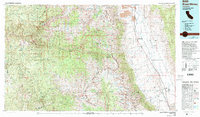 1978 Mount Whitney1992 Print · USGSThe high Sierra and Owens Valley meet in the late 1970s, showcasing the transition from alpine wilderness to valley floor settlements. Trace historical mining operations like the Green Monster Mine or find early routes to the summit near Whitney Portal.
End of results
Showing maps 1-3 of 3
Top cities near Lone Pine
Top neighborhoods of Lone Pine
Frequently asked questions
- What are the different types of historical maps available for Lone Pine?
- What is the oldest map of Lone Pine?
- Where can I purchase historical maps of Lone Pine for my home or office?
- Where can I download high-res historical maps of Lone Pine?
- Are there historical topographic maps available for Lone Pine?
- Is there historical aerial imagery available for Lone Pine?
- Where are historical maps of Lone Pine sourced from?