1950s Maps of West Bishop, California
Explore 4 historic maps of West Bishop from the 1950s. These maps offer a rare glimpse into what life looked like during the 1950s — showing old roads, neighborhoods, homes, and landmarks that have changed or disappeared over time.
Whether you're researching your family's past, planning a metal detecting trip, or studying how West Bishop's landscape evolved across the 1950s, these high-resolution maps are a powerful tool for exploring the history of this region.
- Focus on a specific era: All maps on this page are from the 1950s, giving you a focused view of this time period.
- See what’s changed: Compare century-old streets, trails, and buildings to today's modern landscape using overlays and satellite layers.
- Research with precision: Use these maps for genealogy, historical research, land use analysis, or educational projects.
- View, download, or print: Maps are fully viewable online in high resolution, and can be downloaded or printed for your own records.
Start exploring West Bishop's history through authentic maps from the 1950s. This is your window into the past.
West Bishop, CA maps
(4)- 1951 Map of Mt. Tom
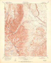 1951 Mt. Tom1951 Print · USGSInyo County mining reached its peak in the early fifties as tungsten and vanadium extraction transformed the eastern Sierra slopes. Researchers can trace the era's industrial footprint through the Pine Creek Mine, Tungsten Hills, and the company town at Rovana.2 unique versions available
 - 1951 Map of Bishop
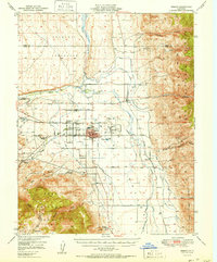 1951 Bishop1951 Print · USGSOwens Valley thrives as an agricultural and mining center in the early fifties, mapped just before local shifts in water and rail. Trace the Southern Pacific line past Laws or locate the Southern Belle Mine and Keough Hot Springs.
 - 1954 Map of Mt. Tom, 1955 Print
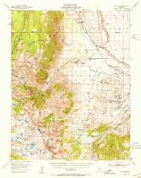 1954 Mt. Tom1955 Print · USGSThe eastern Sierra Nevada is captured here during the peak of its mid-century tungsten mining boom. Genealogists and historians can trace the industrial footprints of Scheelite and Rovana, or locate remote landmarks like Paradise Camp and the Round Valley School.2 unique versions available
 - 1957 Map of Mariposa, 1966 Print
 1957 Mariposa1966 Print · USGSThe High Sierra and Owens Valley appear in the mid-fifties, showing the intersection of conservation, hydroelectric power, and mountain industry. Genealogists and researchers can trace local landmarks like Yosemite Cemetery, the remote Kinsley Station, and the Pine Creek Mine.4 unique versions available
End of results
Showing maps 1-4 of 4
Top cities near West Bishop
- Bishop historical maps
- Dixon Lane–Meadow Creek historical maps
- Big Pine historical maps
- Chalfant Valley historical maps
- Wilkerson historical maps
- Round Valley historical maps
See more
Top neighborhoods of West Bishop
Frequently asked questions
- What are the different types of historical maps available for West Bishop?
- What is the oldest map of West Bishop?
- Where can I purchase historical maps of West Bishop for my home or office?
- Where can I download high-res historical maps of West Bishop?
- Are there historical topographic maps available for West Bishop?
- Is there historical aerial imagery available for West Bishop?
- Where are historical maps of West Bishop sourced from?