1990s Maps of West Bishop, California
Explore 4 historic maps of West Bishop from the 1990s. These maps offer a rare glimpse into what life looked like during the 1990s — showing old roads, neighborhoods, homes, and landmarks that have changed or disappeared over time.
Whether you're researching your family's past, planning a metal detecting trip, or studying how West Bishop's landscape evolved across the 1990s, these high-resolution maps are a powerful tool for exploring the history of this region.
- Focus on a specific era: All maps on this page are from the 1990s, giving you a focused view of this time period.
- See what’s changed: Compare century-old streets, trails, and buildings to today's modern landscape using overlays and satellite layers.
- Research with precision: Use these maps for genealogy, historical research, land use analysis, or educational projects.
- View, download, or print: Maps are fully viewable online in high resolution, and can be downloaded or printed for your own records.
Start exploring West Bishop's history through authentic maps from the 1990s. This is your window into the past.
West Bishop, CA maps
(4)- 1990 Map of Tungsten Hills, 1995 Print
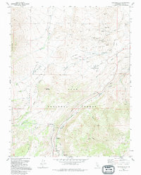 1990 Tungsten Hills1995 Print · USGSThe mining landscape of Inyo County is preserved here in the late twentieth century, showing the intersection of heavy industry and wilderness. Researchers can trace the layout of historical operations like the Aeroplane Mine and Jackrabbit Mine or locate high-country meadows like Sharps Meadow.
 - 1994 Map of Bishop, 1997 Print
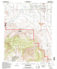 1994 Bishop1997 Print · USGSBishop and the Owens Valley floor are shown in the mid-1990s, revealing a landscape of high-desert settlement and mountain water management. Researchers can trace local landmarks like Keough Hot Springs, the Pioneer Cem, and the Yancy Mine.
 - 1994 Map of Fish Slough, 1997 Print
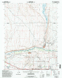 1994 Fish Slough1997 Print · USGSThe northern edge of Bishop meets the high desert in the mid-1990s, revealing a landscape defined by Owens Valley water history. Trace the paths of the South McNally Canal, the Bishop Paiute Indian Res, and the springs of Fish Slough.
 - 1994 Map of Tungsten Hills, 1997 Print
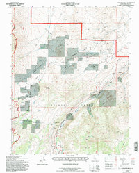 1994 Tungsten Hills1997 Print · USGSInyo County's high desert and mountain slopes are captured here in the mid-nineties, showing the intersection of industrial mining and forest conservation. You can trace early mining claims like the White Caps Mine or locate the infrastructure of the Bishop Creek Aqueduct.
End of results
Showing maps 1-4 of 4
Top cities near West Bishop
- Bishop historical maps
- Dixon Lane–Meadow Creek historical maps
- Big Pine historical maps
- Chalfant Valley historical maps
- Wilkerson historical maps
- Round Valley historical maps
See more
Top neighborhoods of West Bishop
Frequently asked questions
- What are the different types of historical maps available for West Bishop?
- What is the oldest map of West Bishop?
- Where can I purchase historical maps of West Bishop for my home or office?
- Where can I download high-res historical maps of West Bishop?
- Are there historical topographic maps available for West Bishop?
- Is there historical aerial imagery available for West Bishop?
- Where are historical maps of West Bishop sourced from?