1980s Maps of West Bishop, California
Explore 3 historic maps of West Bishop from the 1980s. These maps offer a rare glimpse into what life looked like during the 1980s — showing old roads, neighborhoods, homes, and landmarks that have changed or disappeared over time.
Whether you're researching your family's past, planning a metal detecting trip, or studying how West Bishop's landscape evolved across the 1980s, these high-resolution maps are a powerful tool for exploring the history of this region.
- Focus on a specific era: All maps on this page are from the 1980s, giving you a focused view of this time period.
- See what’s changed: Compare century-old streets, trails, and buildings to today's modern landscape using overlays and satellite layers.
- Research with precision: Use these maps for genealogy, historical research, land use analysis, or educational projects.
- View, download, or print: Maps are fully viewable online in high resolution, and can be downloaded or printed for your own records.
Start exploring West Bishop's history through authentic maps from the 1980s. This is your window into the past.
West Bishop, CA maps
(3)- 1982 Map of Tungsten Hills, 1983 Print
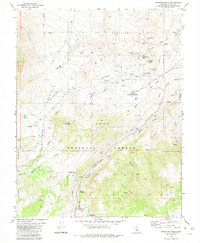 1982 Tungsten Hills1983 Print · USGSThe eastern Sierra Nevada of Inyo County is seen here in the early eighties as a hub of both mining and mountain recreation. Researchers can trace the extensive operations at the Tungsten Blue Mine or locate high-country retreats like Big Trees Campground and Sharps Meadow.2 unique versions available
 - 1984 Map of Fish Slough
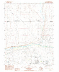 1984 Fish Slough1984 Print · USGSThe Owens Valley area in the mid-1980s reveals a landscape shaped by both geology and irrigation. Researchers can trace the water network from Fish Slough to the Owens River, while locating sites like Brockmans Corner and the Bishop Paute Indian Res.2 unique versions available
 - 1984 Map of Bishop
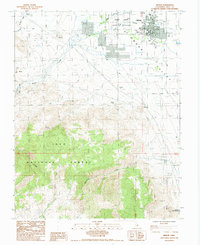 1984 Bishop1984 Print · USGSBishop and the Owens Valley floor are captured here in the mid-1980s, showcasing the intersection of high-desert industry and community life. Genealogists and historians can locate the Pioneer Cem, trace the waters of Keough Hot Springs, or find old mining sites like Chipmunk Mine.2 unique versions available
End of results
Showing maps 1-3 of 3
Top cities near West Bishop
- Bishop historical maps
- Dixon Lane–Meadow Creek historical maps
- Big Pine historical maps
- Chalfant Valley historical maps
- Wilkerson historical maps
- Round Valley historical maps
See more
Top neighborhoods of West Bishop
Frequently asked questions
- What are the different types of historical maps available for West Bishop?
- What is the oldest map of West Bishop?
- Where can I purchase historical maps of West Bishop for my home or office?
- Where can I download high-res historical maps of West Bishop?
- Are there historical topographic maps available for West Bishop?
- Is there historical aerial imagery available for West Bishop?
- Where are historical maps of West Bishop sourced from?