1940s Maps of Lost Hills, California
Explore 3 historic maps of Lost Hills from the 1940s. These maps offer a rare glimpse into what life looked like during the 1940s — showing old roads, neighborhoods, homes, and landmarks that have changed or disappeared over time.
Whether you're researching your family's past, planning a metal detecting trip, or studying how Lost Hills's landscape evolved across the 1940s, these high-resolution maps are a powerful tool for exploring the history of this region.
- Focus on a specific era: All maps on this page are from the 1940s, giving you a focused view of this time period.
- See what’s changed: Compare century-old streets, trails, and buildings to today's modern landscape using overlays and satellite layers.
- Research with precision: Use these maps for genealogy, historical research, land use analysis, or educational projects.
- View, download, or print: Maps are fully viewable online in high resolution, and can be downloaded or printed for your own records.
Start exploring Lost Hills's history through authentic maps from the 1940s. This is your window into the past.
Lost Hills, CA maps
(3)- 1940 Map of Reynolds Ranch
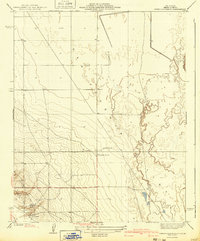 1940 Reynolds Ranch1940 Print · USGSKern County ranching and early irrigation projects are preserved here in the years leading up to the mid-century. Genealogists and local historians can trace the footprints of Reynolds Ranch, Gilbert Ranch, and the path of the Goose Lake Canal.
 - 1942 Map of Hart Station
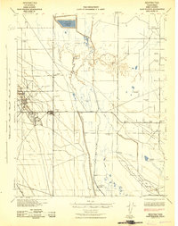 1942 Hart Station1942 Print · USGSThe San Joaquin Valley during the early years of the war reveals an landscape of managed water and private sporting clubs. Genealogists and local historians can trace family-named properties like Cole Ranch and Douglas Ranch or locate the rural Semitropic Sch.
 - 1948 Map of Bakersfield
 1948 Bakersfield1948 Print · USGSBakersfield and the southern San Joaquin Valley appear in the late 1940s, showing a landscape of burgeoning oil towns, rail junctions, and early irrigation canals. Genealogists and historians can trace the foundations of local industry through Gardner Field, the Sunset Railway, and the shores of Buena Vista Lake.2 unique versions available
End of results
Showing maps 1-3 of 3
Top cities near Lost Hills
Frequently asked questions
- What are the different types of historical maps available for Lost Hills?
- What is the oldest map of Lost Hills?
- Where can I purchase historical maps of Lost Hills for my home or office?
- Where can I download high-res historical maps of Lost Hills?
- Are there historical topographic maps available for Lost Hills?
- Is there historical aerial imagery available for Lost Hills?
- Where are historical maps of Lost Hills sourced from?