1950s Maps of Lost Hills, California
Explore 6 historic maps of Lost Hills from the 1950s. These maps offer a rare glimpse into what life looked like during the 1950s — showing old roads, neighborhoods, homes, and landmarks that have changed or disappeared over time.
Whether you're researching your family's past, planning a metal detecting trip, or studying how Lost Hills's landscape evolved across the 1950s, these high-resolution maps are a powerful tool for exploring the history of this region.
- Focus on a specific era: All maps on this page are from the 1950s, giving you a focused view of this time period.
- See what’s changed: Compare century-old streets, trails, and buildings to today's modern landscape using overlays and satellite layers.
- Research with precision: Use these maps for genealogy, historical research, land use analysis, or educational projects.
- View, download, or print: Maps are fully viewable online in high resolution, and can be downloaded or printed for your own records.
Start exploring Lost Hills's history through authentic maps from the 1950s. This is your window into the past.
Lost Hills, CA maps
(6)- 1950 Map of Reynolds Ranch
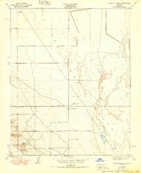 1950 Reynolds Ranch1950 Print · USGSKern County ranching and water management are captured here during the mid-century, reflecting the landscape as it was surveyed in the 1930s. Genealogists and researchers can trace family-named sites such as Gilbert Ranch and Reynolds Ranch or follow the Goose Lake Canal.
 - 1950 Map of West of Goose Lake
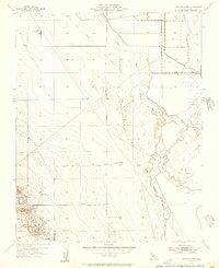
 1950 West of Goose Lake1950 Print · USGSThe northern Kern County oil and agricultural fields are captured here at mid-century, centered on the growing community of Lost Hills. Researchers can trace early roads and infrastructure like the Lost Hills Sch and the path of the West Side Canal.
 - 1953 Map of Lost Hills, 1956 Print
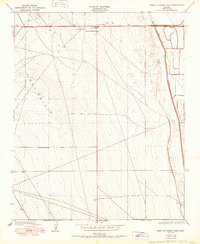
 1953 Lost Hills1956 Print · USGSThe oil fields of Kern County are in full production during the early fifties, centering on the settlement of Lost Hills. Genealogists and industrial historians can trace early petroleum infrastructure including Oil Wells, Oil Tanks, and the Lost Hills Airport.3 unique versions available
 - 1954 Map of Lost Hills NW, 1956 Print
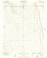
 1954 Lost Hills NW1956 Print · USGSMid-century Kern County comes into focus as an industrial landscape shaped by oil extraction and valley irrigation. Researchers can trace the development of the Lost Hills area through Oil Sumps, the Gilbert Ranch, and the Kern River Channel.3 unique versions available
 - 1955 Map of Bakersfield
 1955 Bakersfield1955 Print · USGSThe southern San Joaquin Valley in the mid-fifties shows an era of massive oil production and industrial irrigation. Trace family roots in Allensworth, the oil fields of Oildale, or the shorelines of Tulare Lake and Buena Vista Lake.
 - 1956 Map of Bakersfield
 1956 Bakersfield1956 Print · USGSThe southern San Joaquin Valley and High Sierra come alive in the mid-fifties, showing the region's complex agricultural and rail networks. Genealogists and historians can trace family roots in towns like Bakersfield, Taft, and Delano, or locate early infrastructure along the Sunset Railway.
End of results
Showing maps 1-6 of 6
Top cities near Lost Hills
Frequently asked questions
- What are the different types of historical maps available for Lost Hills?
- What is the oldest map of Lost Hills?
- Where can I purchase historical maps of Lost Hills for my home or office?
- Where can I download high-res historical maps of Lost Hills?
- Are there historical topographic maps available for Lost Hills?
- Is there historical aerial imagery available for Lost Hills?
- Where are historical maps of Lost Hills sourced from?