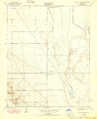
1950 Map of Reynolds Ranch
USGS Topo · Published 1950About this map
Gilbert Ranch and Reynolds Ranch anchor this landscape within the southern reaches of the San Joaquin Valley, illustrating the early 20th-century agricultural development of Kern County. Based on 1932 topography, the map reveals a transition between the valley floor and rising terrain to the west. Water management is a central theme, evidenced by the presence of the Goose Lake Canal meandering through the eastern portion of the sheet. The layout of section lines and isolated settlements like Camp suggest a sparse, ranching-oriented economy typical of the era before more intensive industrial or suburban expansion reached this part of the valley. The map serves as a record of land use and property boundaries in a region defined by its reliance on irrigation infrastructure.
Find a feature on this map
5 named features on this map. Tap any name to fly to it.
Don’t see what you’re looking for? This feature index may not catch every label — zoom into the map to look around manually.
Map Details
Editions of this 1950 Reynolds Ranch Map
This is the sole edition of this map. No revisions or reprints were ever made.
Other maps of this area

1914 · Lost Hills
USGS Topo · 1:125,000

1927 · Semitropic
USGS Topo · 1:31,680

1929 · Hacienda Ranch
USGS Topo · 1:31,680

1930 · Miramonte Ranch
USGS Topo · 1:31,680

1931 · Goose Lake
USGS Topo · 1:31,680

1932 · Antelope Plain
USGS Topo · 1:31,680

1932 · West of Goose Lake
USGS Topo · 1:31,680

1932 · Reynolds Ranch
USGS Topo · 1:31,680

1932 · West Camp
USGS Topo · 1:31,680

1932 · Lone Tree Well
USGS Topo · 1:31,680