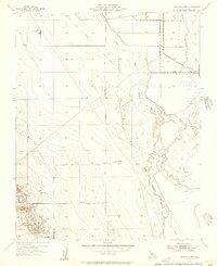
1954 Map of Lost Hills NW
USGS Topo · Published 1956About this map
The rising topography of the Lost Hills defines this portion of the San Joaquin Valley, where industrial activity and water management intersect. While the northern reaches of the map are dominated by the Kern River Channel and a network of levee and pipeline infrastructure, the southern portion reveals the intensive oil extraction landscape near the settlement of Lost Hills. The mapping of numerous Oil Sumps, Tanks, and Pumping Station locations provides a clear picture of the mid-century petroleum industry in Kern County.
Find a feature on this map
15 named features on this map. Tap any name to fly to it.
Don’t see what you’re looking for? This feature index may not catch every label — zoom into the map to look around manually.
Map Details
Editions of this 1954 Lost Hills NW Map
3 editions found
Other maps of this area

1914 · Lost Hills
USGS Topo · 1:125,000

1927 · Semitropic
USGS Topo · 1:31,680

1929 · Hacienda Ranch
USGS Topo · 1:31,680

1930 · Miramonte Ranch
USGS Topo · 1:31,680

1931 · Goose Lake
USGS Topo · 1:31,680

1932 · Antelope Plain
USGS Topo · 1:31,680

1932 · West of Goose Lake
USGS Topo · 1:31,680

1932 · Reynolds Ranch
USGS Topo · 1:31,680

1932 · West Camp
USGS Topo · 1:31,680

1932 · Lone Tree Well
USGS Topo · 1:31,680