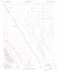
1954 Map of Lost Hills NW
USGS Topo · Published 1976About this map
The topography of the Lost Hills in Kern County reveals a landscape defined by industrial development and water management during the mid-20th century. Scattered across the terrain are numerous Oil Wells, supported by a network of Oil Sumps and Oil Tanks that highlight the region's intensive petroleum extraction. The map also captures the essential infrastructure of California's Central Valley, including the prominent path of the California Aqueduct and the older Kern River Channel. Settlement is sparse, with the Gilbert Ranch serving as a primary point of reference in an area otherwise dedicated to resource management. Notable utility and transportation features like the Lost Hills Airport, various Pipelines, and a Pumping Station illustrate the engineered nature of this arid environment, where Water Tanks and a Reservoir provide critical resources for the local industry.
Find a feature on this map
15 named features on this map. Tap any name to fly to it.
Don’t see what you’re looking for? This feature index may not catch every label — zoom into the map to look around manually.
Map Details
Editions of this 1954 Lost Hills NW Map
3 editions found
Other maps of this area

1914 · Lost Hills
USGS Topo · 1:125,000

1927 · Semitropic
USGS Topo · 1:31,680

1929 · Hacienda Ranch
USGS Topo · 1:31,680

1930 · Miramonte Ranch
USGS Topo · 1:31,680

1931 · Goose Lake
USGS Topo · 1:31,680

1932 · Antelope Plain
USGS Topo · 1:31,680

1932 · West of Goose Lake
USGS Topo · 1:31,680

1932 · Reynolds Ranch
USGS Topo · 1:31,680

1932 · West Camp
USGS Topo · 1:31,680

1932 · Lone Tree Well
USGS Topo · 1:31,680