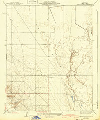
1940 Map of Reynolds Ranch
USGS Topo · Published 1940About this map
Reynolds Ranch and Gilbert Ranch anchor this landscape in the western San Joaquin Valley as it appeared during the late 1930s. The terrain is defined by the sweeping expanse of the Antelope Valley, where irrigation infrastructure begins to transform the arid ground. The presence of the Goose Lake Canal along the eastern edge of the quadrangle signals the agricultural shift that defined Kern County's development in this era. To the southwest, a small Camp is situated near the more varied topography at the edge of the valley floor, likely supporting the labor and ranching activities that were central to the local economy. This 1932 survey, published by the Geological Survey under the direction of state engineer Edward Hyatt, captures a specific moment in the rural management of the region's water and land before more intensive post-war industrialization.
Find a feature on this map
6 named features on this map. Tap any name to fly to it.
Don’t see what you’re looking for? This feature index may not catch every label — zoom into the map to look around manually.
Map Details
Editions of this 1940 Reynolds Ranch Map
This is the sole edition of this map. No revisions or reprints were ever made.
Other maps of this area

1914 · Lost Hills
USGS Topo · 1:125,000

1927 · Semitropic
USGS Topo · 1:31,680

1929 · Hacienda Ranch
USGS Topo · 1:31,680

1930 · Miramonte Ranch
USGS Topo · 1:31,680

1931 · Goose Lake
USGS Topo · 1:31,680

1932 · Antelope Plain
USGS Topo · 1:31,680

1932 · West of Goose Lake
USGS Topo · 1:31,680

1932 · Reynolds Ranch
USGS Topo · 1:31,680

1932 · West Camp
USGS Topo · 1:31,680

1932 · Lone Tree Well
USGS Topo · 1:31,680