1940s Maps of Mojave, California
Explore 10 historic maps of Mojave from the 1940s. These maps offer a rare glimpse into what life looked like during the 1940s — showing old roads, neighborhoods, homes, and landmarks that have changed or disappeared over time.
Whether you're researching your family's past, planning a metal detecting trip, or studying how Mojave's landscape evolved across the 1940s, these high-resolution maps are a powerful tool for exploring the history of this region.
- Focus on a specific era: All maps on this page are from the 1940s, giving you a focused view of this time period.
- See what’s changed: Compare century-old streets, trails, and buildings to today's modern landscape using overlays and satellite layers.
- Research with precision: Use these maps for genealogy, historical research, land use analysis, or educational projects.
- View, download, or print: Maps are fully viewable online in high resolution, and can be downloaded or printed for your own records.
Start exploring Mojave's history through authentic maps from the 1940s. This is your window into the past.
Mojave, CA maps
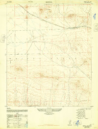
(10)- 1943 Map of Rosamond
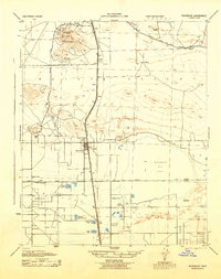 1943 Rosamond1943 Print · USGSThe Mojave Desert comes alive in the early 1940s as a center of mining and rail transit. Researchers can trace the industrial footprint of the Golden Queen Mine, locate the Kern County Union School, and see the early layout of Rosamond.2 unique versions available
 - 1943 Map of Tehachapi
 1943 Tehachapi1943 Print · USGSTehachapi and the surrounding mountain passes are captured in the early 1940s during a period of vital rail and industrial activity. Trace the SOUTHERN PACIFIC line through the Tehachapi Pass or locate rural sites like Jameson Ranch and the Pine Tree Mine.4 unique versions available
 - 1943 Map of Mojave
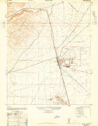
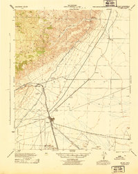 1943 Mojave1943 Print · USGSMid-century Kern County comes alive through this detailed survey of the high desert and mountain passes during the war years. Genealogists and historians can trace the rail lines connecting Mojave to outlying points like Gold Town and the Lucky Dog Mine.2 unique versions available
 - 1943 Map of Willow Springs
 1943 Willow Springs1943 Print · USGSThe northern Antelope Valley and Mojave Desert come alive in this wartime survey of the Kern and Los Angeles county line. Researchers can trace historic family holdings like Wagon Wheel Ranch and C Z Ranch or locate the site of the Cactus Mine.3 unique versions available
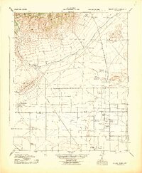
 - 1947 Map of Plano
 1947 Plano1947 Print · USGSKern County's desert terrain is captured here in the late 1940s as military mapping methods were adapted for civilian use. Genealogists and industrial historians can trace the parallel routes of the Southern Pacific and the Lucky Dog Mine.3 unique versions available
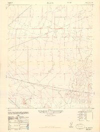
 - 1947 Map of Mojave
 1947 Mojave1947 Print · USGSIn the high desert just after the war, Mojave stands as a vital rail and water hub at the edge of the Tehachapi Mountains. Genealogists and researchers can trace the Los Angeles Aqueduct, the streets of Reefer City, and the layout of the Muroc Naval Air Station (Abandoned).
 - 1947 Map of Bissell
 1947 Bissell1947 Print · USGSThe high desert landscape of Kern County in the late 1940s is defined here by its solitary rail lines and remote outposts. Researchers can trace the path of the Atchison Topeka and Santa Fe railroad and locate family landmarks like De Stazo Ranch and E Brown Ranch.3 unique versions available
 - 1947 Map of Soledad Mountain
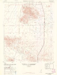 1947 Soledad Mountain1947 Print · USGSThe western Mojave Desert comes alive in the late 1940s, highlighting a landscape defined by gold mining and rail transport. Researchers can trace historic operations at the Golden Queen Mine or follow the Southern Pacific line through Gloster and Actis.
 - 1948 Map of Bakersfield
 1948 Bakersfield1948 Print · USGSBakersfield and the southern San Joaquin Valley appear in the late 1940s, showing a landscape of burgeoning oil towns, rail junctions, and early irrigation canals. Genealogists and historians can trace the foundations of local industry through Gardner Field, the Sunset Railway, and the shores of Buena Vista Lake.2 unique versions available
 - 1949 Map of Los Angeles
 1949 Los Angeles1949 Print · USGSSouthern California and the South Coast appear at the onset of the post-war boom, from the Channel Islands to the Mojave Desert. Trace early aviation sites like Lockheed Air Terminal and mining history at the Redrock Quicksilver Mine and Redrover Mine.2 unique versions available
End of results
Showing maps 1-10 of 10
Top cities near Mojave
Top neighborhoods of Mojave
Frequently asked questions
- What are the different types of historical maps available for Mojave?
- What is the oldest map of Mojave?
- Where can I purchase historical maps of Mojave for my home or office?
- Where can I download high-res historical maps of Mojave?
- Are there historical topographic maps available for Mojave?
- Is there historical aerial imagery available for Mojave?
- Where are historical maps of Mojave sourced from?