1950s Maps of Clearlake, California
Explore 4 historic maps of Clearlake from the 1950s. These maps offer a rare glimpse into what life looked like during the 1950s — showing old roads, neighborhoods, homes, and landmarks that have changed or disappeared over time.
Whether you're researching your family's past, planning a metal detecting trip, or studying how Clearlake's landscape evolved across the 1950s, these high-resolution maps are a powerful tool for exploring the history of this region.
- Focus on a specific era: All maps on this page are from the 1950s, giving you a focused view of this time period.
- See what’s changed: Compare century-old streets, trails, and buildings to today's modern landscape using overlays and satellite layers.
- Research with precision: Use these maps for genealogy, historical research, land use analysis, or educational projects.
- View, download, or print: Maps are fully viewable online in high resolution, and can be downloaded or printed for your own records.
Start exploring Clearlake's history through authentic maps from the 1950s. This is your window into the past.
Clearlake, CA maps
(4)- 1958 Map of Lower Lake, 1961 Print
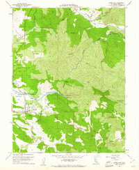 1958 Lower Lake1961 Print · USGSLower Lake and the surrounding Lake County valleys are captured here in the late fifties, showcasing a landscape defined by the winding waters of Cache Creek. Researchers can trace the layout of the town near Union High Sch or locate rural landmarks like the Baker Mine and Pearce Airport.5 unique versions available
 - 1958 Map of Clearlake Highlands, 1961 Print
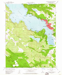 1958 Clearlake Highlands1961 Print · USGSClear Lake's eastern shoreline and the surrounding volcanic highlands are captured here during the late 1950s. Genealogists and local historians can trace the development of Clearlake Highlands and find legacy landmarks like the Burns Valley Sch and Salminas Resort.5 unique versions available
 - 1958 Map of Lower Lake, 1962 Print
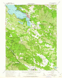 1958 Lower Lake1962 Print · USGSLake County was a burgeoning destination for mineral spring resorts and lakeside living in the late fifties. Genealogists and historians can trace the foundations of Clearlake Highlands, the winding Putah Creek, and historic sites like Hobergs and Sulphur Bank Mine.2 unique versions available
 - 1958 Map of Santa Rosa, 1968 Print
 1958 Santa Rosa1968 Print · USGSThe North Bay and Wine Country are captured in the mid-twentieth century as the region balanced its agricultural roots with a growing military and recreational footprint. Researchers can trace the Northwestern Pacific RR through the Russian River valley or locate landmarks like the Petaluma Adobe Historical Monument and The Geysers Resort.3 unique versions available
End of results
Showing maps 1-4 of 4
Top cities near Clearlake
- Clearlake Riviera historical maps
- Kelseyville historical maps
- Lucerne historical maps
- Nice historical maps
- Clearlake Oaks historical maps
- Cobb historical maps
See more
Top neighborhoods of Clearlake
Frequently asked questions
- What are the different types of historical maps available for Clearlake?
- What is the oldest map of Clearlake?
- Where can I purchase historical maps of Clearlake for my home or office?
- Where can I download high-res historical maps of Clearlake?
- Are there historical topographic maps available for Clearlake?
- Is there historical aerial imagery available for Clearlake?
- Where are historical maps of Clearlake sourced from?