1990s Maps of Clearlake, California
Explore 2 historic maps of Clearlake from the 1990s. These maps offer a rare glimpse into what life looked like during the 1990s — showing old roads, neighborhoods, homes, and landmarks that have changed or disappeared over time.
Whether you're researching your family's past, planning a metal detecting trip, or studying how Clearlake's landscape evolved across the 1990s, these high-resolution maps are a powerful tool for exploring the history of this region.
- Focus on a specific era: All maps on this page are from the 1990s, giving you a focused view of this time period.
- See what’s changed: Compare century-old streets, trails, and buildings to today's modern landscape using overlays and satellite layers.
- Research with precision: Use these maps for genealogy, historical research, land use analysis, or educational projects.
- View, download, or print: Maps are fully viewable online in high resolution, and can be downloaded or printed for your own records.
Start exploring Clearlake's history through authentic maps from the 1990s. This is your window into the past.
Clearlake, CA maps
(2)- 1993 Map of Clearlake Highlands
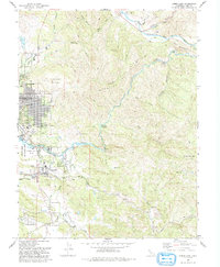
 1993 Clearlake Highlands1993 Print · USGSThe southeastern shores of Clear Lake come alive in the early nineties as residential growth transforms the waterfront. Researchers can trace the development of Clearlake Highlands, locate the Burns Valley School, and explore the protected wetlands of Anderson Marsh State Historical Park.
 - 1993 Map of Lower Lake
 1993 Lower Lake1993 Print · USGSLake County in the early nineties shows a landscape of expanding lakeside communities and rugged backcountry peaks. Genealogists and historians can trace the developments around Lower Lake, the grounds of Yuba College, and the rural site of Baker Mine.2 unique versions available
End of results
Showing maps 1-2 of 2
Top cities near Clearlake
- Clearlake Riviera historical maps
- Kelseyville historical maps
- Lucerne historical maps
- Nice historical maps
- Clearlake Oaks historical maps
- Cobb historical maps
See more
Top neighborhoods of Clearlake
Frequently asked questions
- What are the different types of historical maps available for Clearlake?
- What is the oldest map of Clearlake?
- Where can I purchase historical maps of Clearlake for my home or office?
- Where can I download high-res historical maps of Clearlake?
- Are there historical topographic maps available for Clearlake?
- Is there historical aerial imagery available for Clearlake?
- Where are historical maps of Clearlake sourced from?