Old Maps of Hayden Hill, California
Explore 16 old maps of Hayden Hill, spanning from 1886 to today. These high-resolution historic maps reveal how streets, neighborhoods, landmarks, and natural features evolved over time — perfect for genealogy, metal detecting, research, and local history exploration.
What you can do with these maps:
- See how Hayden Hill changed over time: Compare historical maps to modern-day views to trace roads, homesites, rail lines & more.
- View detailed metadata: Each map includes creators, publishers, year, scale, and archive source.
- Overlay maps with satellite & LiDAR: Visualize the past alongside modern tools to explore terrain & human change.
- Trusted historical sources: Maps sourced from the USGS, Library of Congress, and other archives.
- Access maps your way: View online, download high-res files, or order prints for personal or research use.
Start exploring old maps of Hayden Hill to uncover forgotten places, hidden landmarks, and the deep history beneath your feet.
Hayden Hill, CA maps
(16)- 1886 Map of Honey Lake
 1886 Honey Lake1886 Print · USGSLassen and Plumas counties were a frontier of ranching and early commerce in the late nineteenth century. Genealogists can locate family-named settlements like Stocktons and Taylorsville or trace the early water rights near Susanville and Honey Lake.
 - 1891 Map of Honey Lake
 1891 Honey Lake1891 Print · USGSLassen and Plumas counties appear here in the early 1890s, when the region's cattle ranches and mountain towns were first being systematically mapped. Genealogists and local historians can trace early residents through family-named sites like Halls, Buntingville, and Stocktons.
 - 1893 Map of Honey Lake
 1893 Honey Lake1893 Print · USGSNortheastern California at the close of the 19th century was a landscape of terminal lakes and early valley settlements. Genealogists and historians can trace family-named sites like Moultons and Stocktons, alongside regional hubs like Susanville and the lakeside town of Amedee.6 unique versions available
 - 1955 Map of Westwood, 1959 Print
 1955 Westwood1959 Print · USGSIn the mid-fifties, the northeastern California interior supported a landscape of mountain timber and high-desert basins. Genealogists and historians can locate early settlements and industrial sites like Susanville, Herlong, and the Sierra Ordinance Depot.
 - 1956 Map of Hayden Hill, 1957 Print
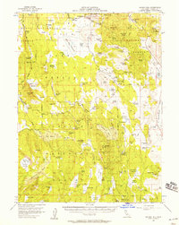 1956 Hayden Hill1957 Print · USGSThe high country of Lassen and Modoc counties comes into focus in the mid-1950s, revealing a landscape of high-altitude camps and essential waterholes. Researchers can trace the layout of Hayden Hill, locate the local Cem, or identify ranching landmarks like Totten Camp and Silva Flat Reservoir.3 unique versions available
 - 1958 Map of Westwood
 1958 Westwood1958 Print · USGSNorthern California in the late fifties shows a landscape of volcanic peaks and rising reservoirs. Researchers can locate the Sierra Ordinance Depot and trace mountain infrastructure through the Hat Creek Ranger Station and Stacy Siding.
 - 1959 Map of Westwood
 1959 Westwood1959 Print · USGSNortheastern California during the late 1950s was a hub of timber, military logistics, and mountain railroading. Researchers can trace the path of the Southern Pacific through the Honey Lake Valley and locate landmarks like the Sierra Ordinance Depot and Lassen Peak.
 - 1962 Map of Susanville, 1965 Print
 1962 Susanville1965 Print · USGSNortheastern California's high desert and volcanic peaks meet in the early sixties, showing the region's timber and rail hubs in transition. Local historians can trace the Southern Pacific lines through Susanville and Litchfield, or explore the sprawling Sierra Army Depot and Lassen Volcanic National Park.2 unique versions available
 - 1968 Map of Susanville
 1968 Susanville1968 Print · USGSThe high Sierras and the Great Basin collide in the late 1960s, showing a landscape of volcanic peaks, timber settlements, and desert plains. Genealogists and researchers can trace historic rail lines like the Western Pacific or locate residents in Susanville, Westwood, and Janesville.
 - 1983 Map of Silva Flat Reservoir
 1983 Silva Flat Reservoir1983 Print · USGSLassen County's high-plateau water systems are documented here in the early eighties as a network of reservoirs and springs. Researchers can trace the ranching and mining footprint via Hayden Hill, the local Cem, and sites like Log Cabin Reservoir No 1.
 - 1992 Map of Eagle Lake
 1992 Eagle Lake1992 Print · USGSHigh desert plains and volcanic peaks meet the shores of Eagle Lake in the early nineties. Genealogists and local historians can trace the Southern Pacific rail line through Ravendale and Termo or locate remote sites like Fredonyer and Karlo.2 unique versions available
 - 1993 Map of Silva Flat Reservoir, 1996 Print
 1993 Silva Flat Reservoir1996 Print · USGSThe high plateau of Lassen and Modoc counties was a landscape of remote ranching and water engineering in the 1990s. Genealogists and historians can trace water rights and family-named landmarks like Ollie Rivis Spring, Summers Hill, and the isolated Cem near Hayden Hill.
 - 2012 Map of Silva Flat Reservoir, 2012 Print
 2012 Silva Flat Reservoir2012 Print · USGSCovers Hayden Hill, including Lassen County, United States, and other nearby areas
 - 2015 Map of Silva Flat Reservoir, 2015 Print
 2015 Silva Flat Reservoir2015 Print · USGSCovers Hayden Hill, including Lassen County, United States, and other nearby areas
 - 2018 Map of Silva Flat Reservoir, 2018 Print
 2018 Silva Flat Reservoir2018 Print · USGSCovers Hayden Hill, including Lassen County, United States, and other nearby areas
 - 2021 Map of Silva Flat Reservoir, 2021 Print
 2021 Silva Flat Reservoir2021 Print · USGSLassen County's high-plateau borderlands are captured here in the early twenty-first century, showing a landscape defined by forest boundaries and water management. Researchers can locate Hayden Hill Cem and trace the complex series of basins like Silva Flat Reservoir and Coyote Reservoir.
End of results
Showing maps 1-16 of 16
Top cities near Hayden Hill
Frequently asked questions
- What are the different types of historical maps available for Hayden Hill?
- What is the oldest map of Hayden Hill?
- Where can I purchase historical maps of Hayden Hill for my home or office?
- Where can I download high-res historical maps of Hayden Hill?
- Are there historical topographic maps available for Hayden Hill?
- Is there historical aerial imagery available for Hayden Hill?
- Where are historical maps of Hayden Hill sourced from?