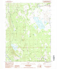
1983 Map of Silva Flat Reservoir
USGS Topo · Published 1983About this map
Silva Flat Reservoir anchors a high-elevation landscape within the Modoc National Forest near the Lassen and Modoc county line. This early 1980s survey reveals a territory defined by an extensive network of water management, ranging from the large Coyote Reservoir to smaller stock and catchment basins like Deadhorse Reservoir and Tire Body Reservoir. The presence of the Cem and Prospect near Hayden Hill in the northeast corner points to the area's history of mineral extraction and early settlement. Named features such as Ollie Rivis Spring and Bunselmeier Spring indicate a reliance on natural water sources for cattle or camps, while the State Game Refuge designation across much of the terrain reflects a 20th-century focus on conservation and wildlife management.
Find a feature on this map
47 named features on this map. Tap any name to fly to it.
Don’t see what you’re looking for? This feature index may not catch every label — zoom into the map to look around manually.
Map Details
Editions of this 1983 Silva Flat Reservoir Map
This is the sole edition of this map. No revisions or reprints were ever made.
Other maps of this area

1886 · Alturas
USGS Topo · 1:250,000

1886 · Honey Lake
USGS Topo · 1:250,000

1886 · Lassen Peak
USGS Topo · 1:250,000

1886 · Modoc Lava Bed
USGS Topo · 1:250,000

1891 · Honey Lake
USGS Topo · 1:250,000

1892 · Modoc Lava-Bed
USGS Topo · 1:250,000

1892 · Lassen Peak
USGS Topo · 1:250,000

1892 · Alturas
USGS Topo · 1:250,000

1893 · Honey Lake
USGS Topo · 1:250,000

1894 · Lassen Peak
USGS Topo · 1:250,000