Old Maps of El Monte, California for Academic Research
Study the evolution of El Monte with 42 high-resolution historic maps. Whether you're teaching, researching, or modeling changes in land use, these maps provide essential visual documentation of urban, environmental, and geographic change.
- Analyze long-term change: Track patterns in development, transportation, and natural features.
- Ideal for environmental or urban studies: Support academic projects with primary historical map data.
- Use in the classroom or lab: Educators and researchers rely on these maps to bring historical context to life.
These maps are a powerful tool for teaching, research, and visualizing how El Monte has changed over the decades.
El Monte, CA maps
(42)- 1894 Map of Los Angeles
 1894 Los Angeles1894 Print · USGSLos Angeles was a growing rail hub at the end of the nineteenth century, balancing its agricultural heritage with new mountain resorts. Researchers can trace early neighborhoods like Boyle Heights, find the National Soldiers Home, or follow the Mt. Lowe Hotel incline.
 - 1894 Map of Pomona, 1960 Print
 1894 Pomona1960 Print · USGSThe eastern San Gabriel Valley is shown here in the 1890s, when the orchard economy and railroads were first reshaping the landscape. Genealogists and historians can trace early settlements and rail stops like Lordsburg, Alosta, and Rowland Siding.
 - 1896 Map of Pasadena
 1896 Pasadena1896 Print · USGSGreater Los Angeles was a network of rail-connected resort towns and historic missions in the late nineteenth century. You can trace early transit lines to the Raymond Hotel, locate the original Mission site, and find vanished stops like Las Casetas Sta.2 unique versions available
 - 1897 Map of Pomona
 1897 Pomona1897 Print · USGSThe San Gabriel Valley is captured here in the late nineteenth century as a patchwork of citrus-growing colonies and emerging rail towns. Genealogists and historians can trace early property lines and settlements like Lordsburg, Alosta, and Spadra along the Covina Branch line.
 - 1898 Map of Pomona
 1898 Pomona1898 Print · USGSThe San Gabriel Valley is captured here during its late nineteenth-century rail boom, before the suburban expansion of the Los Angeles basin. Genealogists can trace the early streets of Pomona, Lordsburg, and San Dimas along the busy Southern Pacific Railroad.2 unique versions available
 - 1900 Map of Pasadena
 1900 Pasadena1900 Print · USGSThe San Gabriel Valley is captured here at a pivotal moment of expansion just as the rail networks reached the foothills. Researchers can trace the layout of early Pasadena and Monrovia, locate the Echo Mountain Mt. Lowe Hotel, or find the historic Mission and Raymond Hotel.10 unique versions available
 - 1900 Map of Los Angeles
 1900 Los Angeles1900 Print · USGSGreater Los Angeles was a mosaic of expansive ranchos and emerging rail towns at the turn of the century. You can trace the early footprints of Hollywood, locate the historic Soldiers Home, and follow the mountain rails to the Echo Mountain Mt. Lowe Hotel.4 unique versions available
 - 1901 Map of Southern California Sheet No. 1
 1901 Southern California Sheet No. 11901 Print · USGSGreater Los Angeles at the dawn of the twentieth century is a landscape of growing citrus towns and a burgeoning rail network. Genealogists and historians can trace the early gridded streets of Hollywood and Pasadena or locate landmarks like Bear Lake and the Cahuilla Indian Reservation.6 unique versions available
 - 1904 Map of Pomona
 1904 Pomona1904 Print · USGSThe eastern San Gabriel Valley is shown here at the turn of the century as a burgeoning network of citrus towns and vital rail lines. Genealogists can trace early homesteads and vanished stops such as Lordsburg, Alosta, and the Rowland Siding along the Southern Pacific RR.7 unique versions available
 - 1904 Map of Southern California Sheet No. 1, 1905 Print
 1904 Southern California Sheet No. 11905 Print · USGSSouthern California at the dawn of the twentieth century shows a landscape of citrus groves and coastal towns connected by rail. Genealogists and historians can trace early settlements like San Juan Capistrano, find remote sites like the Rose Mine, and study the original water systems of the Santa Ana River.2 unique versions available
 - 1923 Map of El Monte
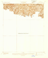
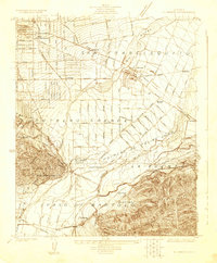 1923 El Monte1923 Print · USGSThe San Gabriel Valley was a thriving agricultural and rail corridor in the years following the Great War. You can trace early township boundaries and find the sites of rural schools and industry, from the O'Donnel Oil Refinery to the Temple School.
 - 1926 Map of El Monte
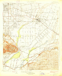 1926 El Monte1926 Print · USGSThe San Gabriel Valley in the mid-twenties shows a landscape of historic ranchos transitioning into suburban clusters along the rail lines. Genealogists and researchers can trace early homesteads and schools like Temple School or the industrial footprint of the O'Donnel Oil Refinery.2 unique versions available
 - 1927 Map of Puente
 1927 Puente1927 Print · USGSThe San Gabriel Valley is shown in the late twenties during its era of agricultural prominence and early rail expansion. Genealogists can trace family tracts and rural community centers like Fellowship Farm, Temple Ranch, and the West Covina School.2 unique versions available
 - 1928 Map of Sierra Madre
 1928 Sierra Madre1928 Print · USGSThe San Gabriel Valley foothills were rapidly expanding in the late twenties as orchard lands gave way to suburban tracts. Genealogists and researchers can trace early homesteads and rail lines like the Pacific Electric, the Temple School, and the historic Mission San Gabriel.
 - 1933 Map of Sierra Madre
 1933 Sierra Madre1933 Print · USGSThe foothills of the San Gabriel Mountains come alive in the 1930s as residential growth meets the rugged canyons of the Angeles National Forest. Genealogists and hikers can trace early mountain retreats like Orchard Camp, Henninger Flats, and the First Water Resort.
 - 1941 Map of Sierra Madre
 1941 Sierra Madre1941 Print · USGSThe San Gabriel foothills and burgeoning valley floor are captured here just before the mid-century population explosion. Genealogists and local historians can trace the early layouts of Arcadia, Sierra Madre, and the historic Kinneloa Ranch near the Pacific Electric lines.2 unique versions available
 - 1948 Map of El Monte
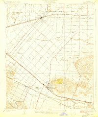
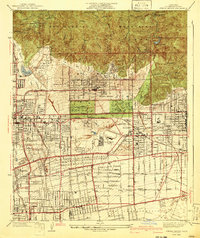
 1948 El Monte1948 Print · USGSThe San Gabriel Valley is shown in the late 1940s as citrus groves gave way to mid-century neighborhoods. Genealogists can trace family roots through numerous local landmarks, including the Rosemead Lodge Sanitarium, Savannah Sch, and Rose Hill Memorial Park.
 - 1949 Map of Los Angeles
 1949 Los Angeles1949 Print · USGSSouthern California and the South Coast appear at the onset of the post-war boom, from the Channel Islands to the Mojave Desert. Trace early aviation sites like Lockheed Air Terminal and mining history at the Redrock Quicksilver Mine and Redrover Mine.2 unique versions available
 - 1953 Map of San Bernardino
 1953 San Bernardino1953 Print · USGSSouthern California underwent massive post-war growth as suburban sprawl reached the foothills of the San Bernardino Mountains. Genealogists and historians can trace the rail-and-road roots of the Inland Empire through the Union Pacific RR and Lake Arrowhead resorts.2 unique versions available
 - 1953 Map of El Monte, 1955 Print
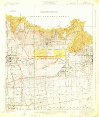
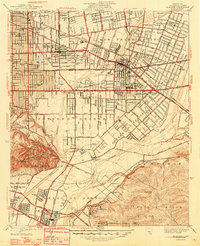
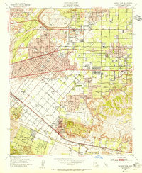
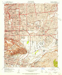 1953 El Monte1955 Print · USGSThe San Gabriel Valley was undergoing a massive suburban transformation in the early fifties. Genealogists and local historians can trace the footprint of the San Gabriel Mission, the Pasadena-Rosemead Airport, and numerous Oil Wells before the valley's open lands were fully developed.2 unique versions available
 - 1953 Map of Baldwin Park, 1955 Print
 1953 Baldwin Park1955 Print · USGSThe San Gabriel Valley in the mid-fifties is captured here as orange groves and river washes give way to suburban sprawl. Researchers can trace the legacy of local schools and specialized facilities like St Johns School or the Sierra Lodge Sanitarium.2 unique versions available
 - 1955 Map of Los Angeles
 1955 Los Angeles1955 Print · USGSThe mid-century transformation of Southern California comes into focus as the urban sprawl of Los Angeles meets the wilderness of the Santa Monica Mountains. Researchers can trace the development of post-war suburbs alongside historic landmarks like the Santa Barbara Lighthouse and early industrial sites such as the Good Luck Mine.
 - 1956 Map of San Bernardino
 1956 San Bernardino1956 Print · USGSSouthern California's Inland Empire and High Desert come into focus in the mid-fifties as agriculture gives way to suburban and military growth. Trace early rail lines like the Pacific Electric or find remote landmarks like Camp Rock Mine and George AFB.
 - 1957 Map of San Bernardino
 1957 San Bernardino1957 Print · USGSSouthern California's Inland Empire and High Desert met during the postwar expansion of the late fifties. Genealogists and historians can trace the growth of San Bernardino and Redlands alongside remote landmarks like Edwards AFB and the Camp Rock Mine.
 - 1958 Map of San Bernardino, 1975 Print
 1958 San Bernardino1975 Print · USGSSouthern California’s Inland Empire and High Desert come into focus during the mid-century boom, showing the rise of suburbs and massive military installations. Researchers can trace the rail networks of the Union Pacific RR or locate landmarks like Norton AFB and Big Bear Lake.
Showing maps 1-25 of 42
Top cities near El Monte
- Los Angeles historical maps
- Long Beach historical maps
- Anaheim historical maps
- Glendale historical maps
- Pomona historical maps
- Pasadena historical maps
See more
Top neighborhoods of El Monte
Frequently asked questions
- What are the different types of historical maps available for El Monte?
- What is the oldest map of El Monte?
- Where can I purchase historical maps of El Monte for my home or office?
- Where can I download high-res historical maps of El Monte?
- Are there historical topographic maps available for El Monte?
- Is there historical aerial imagery available for El Monte?
- Where are historical maps of El Monte sourced from?